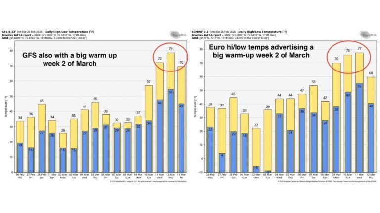
Jan. 23–25, 2026 Winter Storm Spreads Snow, Ice, and Warnings Across Texas, Midwest, Appalachians, and Northeast
UNITED STATES — A massive winter storm that unfolded between January 23 and January 25, 2026, has entered the record books for its extraordinary size and nationwide reach, impacting a huge portion of the country at the same time with snow, ice, sleet, and dangerous winter conditions. As daylight arrived Sunday morning, warnings and advisories slowly began to disappear, signaling the end of one of the broadest winter weather events in recent U.S. history.
A Single Storm Covering an Unusually Large Part of the Country
What set this system apart was not just how much snow or ice fell in any one place, but the sheer geographic footprint of the storm. Winter weather alerts stretched from Texas and the Southern Plains through the Mid-South, Ohio Valley, Appalachians, and into the Northeast, all tied to the same large-scale system.
States including Texas, Oklahoma, Arkansas, Louisiana, Mississippi, Tennessee, Kentucky, Missouri, Illinois, Indiana, Ohio, West Virginia, Virginia, Pennsylvania, New York, and much of New England were under winter storm warnings, ice storm warnings, or winter weather advisories during the peak of the event.
Snow and Ice Combined to Create Dangerous Conditions
Across the southern and central portions of the storm, freezing rain and sleet became a major concern, especially in parts of Texas, Arkansas, Tennessee, Kentucky, and the southern Appalachian region. Ice accumulation led to hazardous travel, downed trees, and scattered power outages in several areas.
Farther north, persistent snow bands developed across parts of the Midwest and Northeast, creating long-duration snowfall events that slowed travel and strained road crews. In some regions, snow fell on top of earlier ice, making roads even more dangerous.
Why Meteorologists Are Calling This an “Elite-Scale” Winter Storm
Forecasters noted that regardless of whether snowfall or ice totals overperformed or underperformed in individual locations, the size of the storm alone places it in an elite category. It is uncommon for a single winter system to:
- Span so many climate zones at once
- Produce snow, sleet, freezing rain, and rain simultaneously
- Place winter alerts over dozens of states at the same time
The storm’s reach made it especially challenging for emergency managers and transportation agencies, as impacts varied widely from region to region under the same system.
Aftermath and Lingering Impacts as Warnings Fade
As warnings expired Sunday morning, many communities were left dealing with residual ice, snow-covered secondary roads, delayed travel, and localized infrastructure issues. Even in areas where precipitation had ended, cold air lingering behind the system kept conditions hazardous.
For meteorologists and weather historians, the January 23–25, 2026 winter storm will likely be remembered not for a single extreme statistic, but for how much of the United States it affected all at once—a rare and remarkable event by any standard. If this storm impacted your area with snow, ice, travel disruptions, or power issues, share your experience and continue following regional weather coverage at CabarrusWeekly.com.