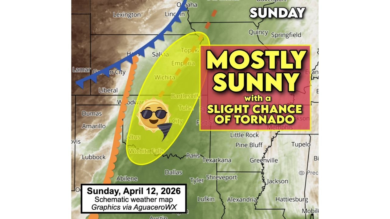
Kansas and Oklahoma Face Unusual Sunday Setup With Mostly Sunny Skies but Conditional Tornado Risk if Storm Cap Breaks
KANSAS — An unusual and somewhat deceptive weather setup is expected Sunday across parts of the Southern Plains, where conditions may appear calm on the surface but still carry a low-probability severe weather risk.
Mostly Sunny Conditions Expected Across the Region
Forecast conditions suggest that much of Kansas and Oklahoma will experience mostly sunny skies throughout the day.
A strong cap — a layer of warm, dry air aloft — is expected to limit thunderstorm development, keeping skies clearer than typical during severe weather setups.
Understanding the “Conditional” Severe Weather Risk
Despite the quiet appearance, the setup includes what forecasters call a “conditional risk”, meaning storms may not develop at all — but if they do, they could quickly become severe.
In this case, the environment supports two possible outcomes:
either little to no storm activity,
or a brief window for a strong storm capable of producing severe weather.
Low Probability but High Impact Potential
Current expectations suggest that the majority outcome is no storm development, with the odds heavily favoring dry conditions.
However, there remains a smaller chance for a rogue thunderstorm, and if that occurs, it could tap into a favorable environment for hail, strong winds, and even a brief tornado.
The Role of the Cap in Storm Development
The key factor controlling Sunday’s forecast is the atmospheric cap.
This layer acts like a lid, preventing warm, moist air near the surface from rising and forming storms. As long as the cap remains intact, storm development will be suppressed.
If the cap weakens or breaks in isolated areas, rapid storm development could occur, allowing storms to intensify quickly.
Why Tornado Risk Still Exists
Even though storm chances are low, the environment below the cap contains sufficient instability and wind dynamics to support rotation.
This means that any storm that does manage to form could become organized quickly, with the potential to produce a brief tornado.
What to Expect Through Sunday
For most areas across Kansas and Oklahoma, Sunday will likely remain quiet, warm, and mostly sunny.
However, residents should remain aware of the possibility that conditions could change quickly in isolated spots, especially during the late afternoon or early evening hours.
Key Takeaway
This setup highlights a classic Plains scenario where calm weather masks a low-probability but potentially impactful severe risk.
Even with mostly sunny skies, the environment still holds the ingredients needed for a brief but intense storm if conditions align.
Stay with CabarrusWeekly.com for updates, and share what conditions you are seeing in your area as this unusual weather setup unfolds.