Kansas, Missouri Face Multi-Day Storm Pattern With 2 to 4 Inches Rainfall and Repeated Thunderstorm Rounds Through Saturday
KANSAS — An extended stretch of unsettled weather is expected to take hold across the central Plains, with multiple rounds of showers and thunderstorms from Tuesday through Saturday bringing widespread heavy rainfall.
Repeated Storm Rounds Expected Through Late Week
The pattern will feature several waves of showers and thunderstorms moving across Kansas and Missouri, beginning Tuesday afternoon and continuing through the end of the week.
This setup is driven by a persistent storm track over the region, allowing new rounds of precipitation to develop repeatedly over the same areas.
As a result, rainfall will not come from a single system but rather multiple episodes that build total accumulation over time.
Widespread 2 to 4 Inches of Rain Forecast
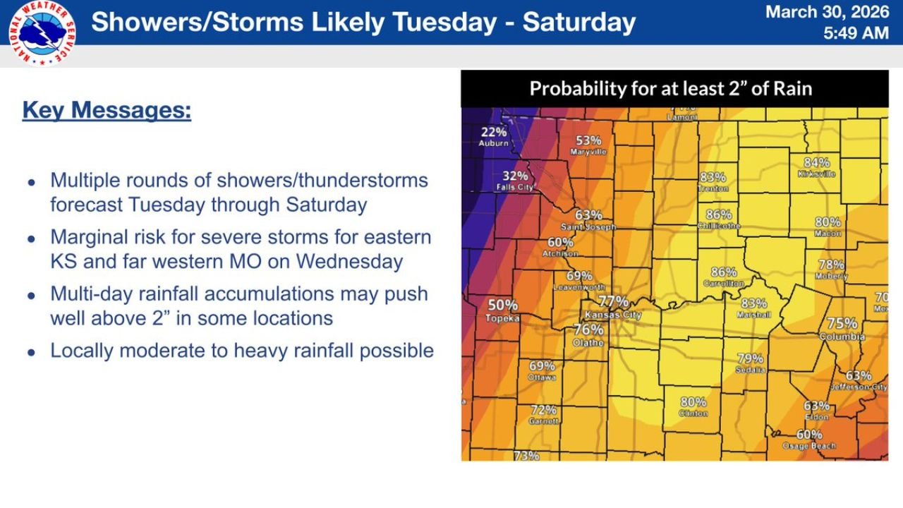
Forecast guidance indicates widespread rainfall totals between 2 and 4 inches, with some locations potentially exceeding that range.
The probability of receiving at least 2 inches of rain is high across much of the region, especially in eastern Kansas and western to central Missouri, including areas near Kansas City, Columbia, and surrounding communities.
Localized totals could climb even higher where storms repeatedly track over the same locations.
Locally Heavy Rain Could Lead to Flooding Concerns
With multiple rounds of rain expected, locally moderate to heavy rainfall may create flooding concerns, particularly in low-lying or flood-prone areas.
Periods of heavier downpours could lead to rapid water accumulation, especially if storms train over the same region.
Urban areas and locations with poor drainage may be especially vulnerable during peak rainfall periods.
Midweek Severe Storm Risk Remains Limited but Present
While the primary concern is heavy rainfall, there is also a marginal risk for severe storms, particularly on Wednesday across eastern Kansas and far western Missouri.
These storms could produce gusty winds and lightning, though widespread severe weather is not expected at this time.
The focus will remain on the cumulative rainfall impact rather than isolated severe hazards.
Long Duration Event Increases Impact Potential
The extended duration of this pattern is one of the biggest concerns, as several days of repeated rainfall can quickly saturate the ground.
Even if individual storms are not extreme, the combination of multiple rounds increases the likelihood of runoff issues and localized flooding.
Residents should monitor forecasts closely as rainfall totals may increase if the pattern slows or becomes more concentrated.
Stay with CabarrusWeekly.com for continued updates, and share what conditions you are seeing in your area as this multi-day storm system unfolds.