Kansas, Nebraska and Missouri Face Today’s Severe Storm Setup With Supercells, Large Hail and Isolated Tornado Risk Developing Along Frontal Boundary
MISSOURI — A focused severe weather setup is expected to develop today across parts of the Central Plains, where a stalled frontal boundary is likely to trigger afternoon and evening thunderstorms with all severe hazards possible.
Slight Risk Area Targets Kansas, Nebraska and Northwest Missouri
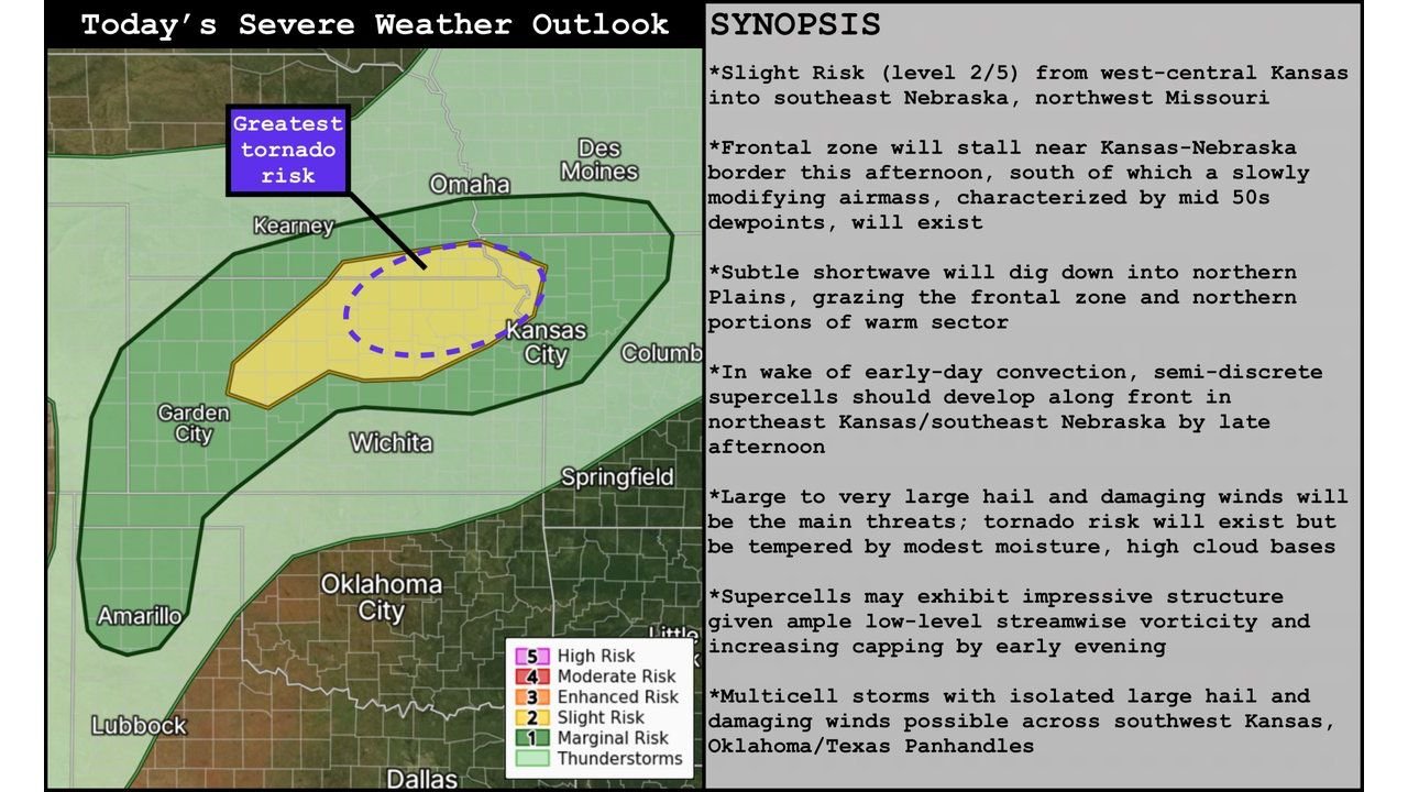
The Storm Prediction Center has outlined a Slight Risk (Level 2 of 5) stretching from west-central Kansas into southeast Nebraska and northwest Missouri. This corridor represents the most favorable zone for organized severe storms later today.
Within this region, atmospheric conditions are aligning to support storm development along a stalled front near the Kansas–Nebraska border, which will act as the primary trigger for thunderstorm initiation.
Supercells Expected to Develop by Late Afternoon
As daytime heating increases and instability builds, semi-discrete supercells are expected to form by late afternoon, particularly across northeast Kansas and southeast Nebraska.
These storms will likely become organized quickly, with the potential to produce large to very large hail and damaging wind gusts. The combination of moisture and instability will allow storms to intensify rapidly once they develop.
Tornado Risk Present but Conditional
While the primary threats remain hail and wind, a tornado risk does exist, especially within the strongest supercells. However, this threat is considered somewhat limited due to modest moisture levels and relatively high cloud bases.
That said, localized conditions near the frontal boundary could still allow for brief tornado development, particularly where storm rotation becomes more pronounced.
Atmospheric Setup Supports Organized Storm Structure
The environment across the region includes mid-50s dew points south of the front, providing enough moisture for storm development. In addition, a subtle upper-level disturbance moving into the northern Plains will enhance lift and support storm organization.
As the evening progresses, increasing wind energy in the lower atmosphere may allow storms to exhibit impressive structure and stronger rotation, especially in areas closer to the Kansas–Nebraska border.
Additional Storm Activity Across Southwest Kansas and Oklahoma
Outside of the main risk zone, additional thunderstorms may develop across southwest Kansas, the Oklahoma Panhandle, and parts of the Texas Panhandle.
These storms are more likely to form as multicell clusters, but they can still produce isolated large hail and damaging wind gusts, adding to the overall severe weather footprint across the region.
Timing and What to Watch
The most active period is expected during the late afternoon through early evening hours, when storm coverage and intensity are likely to peak.
Residents across Kansas, Nebraska, and northwest Missouri should remain alert for rapidly changing conditions, especially in areas near the frontal boundary where the strongest storms and highest severe risk will be concentrated.
Stay with CabarrusWeekly.com for continued updates, and share what weather conditions you are seeing in your area as storms develop today.