Kansas, Oklahoma and Nebraska Face Renewed Tornado Signals Thursday as High-Resolution Model Lights Up Central Plains
KANSAS — A renewed severe weather signal is emerging for parts of Kansas, Oklahoma and Nebraska late Thursday into early Friday, as high-resolution model data highlights a corridor of intense storm rotation across the Central Plains.
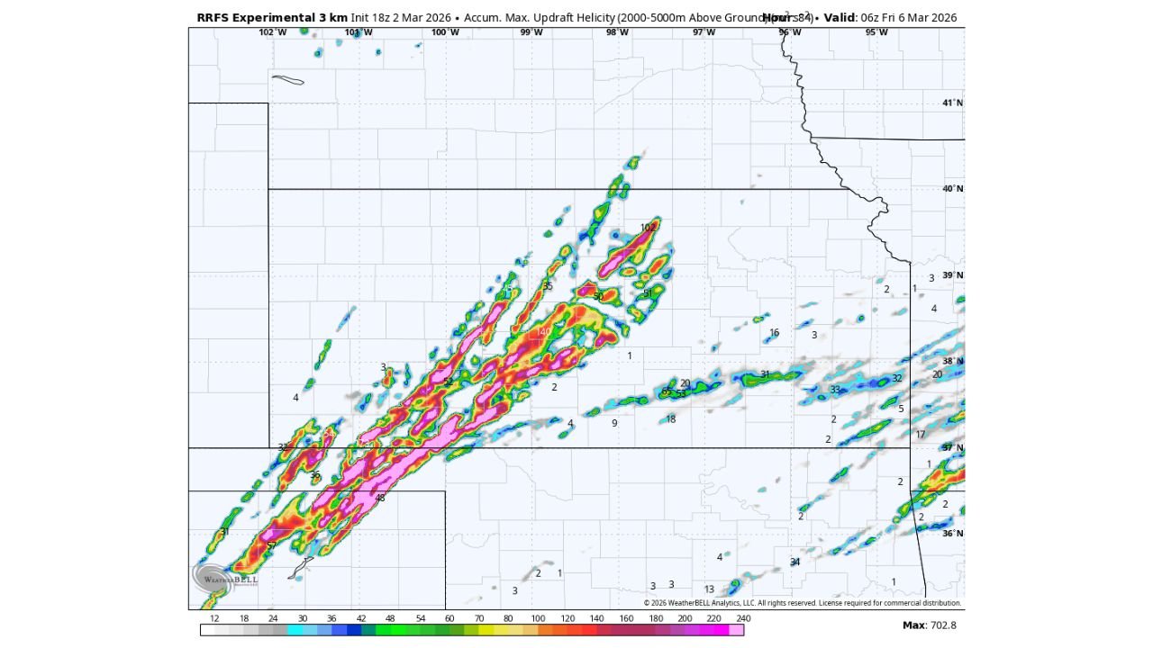
New experimental 3km model guidance shows a pronounced southwest-to-northeast swath of strong updraft helicity — a key indicator of rotating thunderstorms capable of producing tornadoes — stretching from western Oklahoma through central and eastern Kansas and into southern Nebraska.
Strong Rotation Signal Across Kansas
The model’s accumulated maximum updraft helicity field shows several elongated streaks of intense rotation across:
- Western and central Kansas
- Portions of northern Oklahoma
- Extending into southern Nebraska
Some of the strongest signals appear across central Kansas, where multiple embedded streaks suggest discrete supercells rather than a messy, linear storm mode.
Discrete supercells are typically more efficient tornado producers, particularly when instability and wind shear overlap.
Storm Mode Appears Favorable for Organized Supercells
The orientation of the rotating streaks suggests storms may initiate in western Oklahoma or far western Kansas before tracking northeastward into central and eastern Kansas.
This setup implies:
- Organized storm structures
- Potential for long-tracked supercells
- A corridor of enhanced tornado risk
The southwest-to-northeast alignment also indicates strong mid-level flow steering storms into more populated areas of eastern Kansas later in the evening.
Timing: Thursday Evening Into Early Friday
The model run valid around 06z Friday (early Friday morning) suggests that the most intense rotation may occur during the late evening hours Thursday and potentially persist after dark.
Nighttime tornado risk is particularly dangerous due to:
- Reduced visibility
- Sleeping residents
- Faster storm motions
Residents across Kansas and northern Oklahoma should closely monitor updated forecasts as Thursday approaches.
What This Means for the Carolinas
While this system is centered in the Plains, large-scale pattern changes often propagate eastward over time.
Cabarrus County and the broader North Carolina Piedmont are not currently in the direct risk zone for this particular event. However, the same broader jet stream configuration driving Plains severe weather can influence Southeast weather patterns in the days that follow.
Why Updraft Helicity Matters
Updraft helicity measures the strength and persistence of rotating updrafts within thunderstorms.
Higher values and longer streaks often correlate with:
- Supercell thunderstorms
- Tornado potential
- Large hail and damaging wind risk
The experimental model’s maximum values exceed 700 m²/s² in some areas — an indication that the atmospheric environment may strongly support organized rotating storms if storms can initiate cleanly.
Bottom Line
Thursday could once again place Kansas, Oklahoma and Nebraska in the spotlight for severe weather, with model guidance signaling organized supercells capable of tornadoes.
CabarrusWeekly.com will continue monitoring national severe weather trends and provide updates if pattern shifts begin impacting North Carolina.