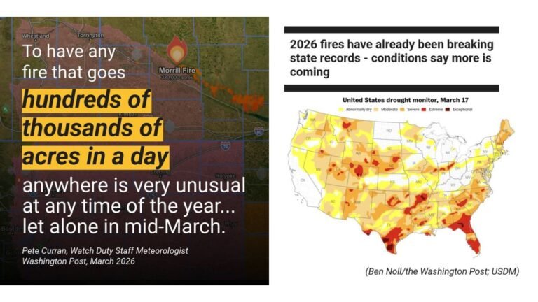
Kansas, Oklahoma, Missouri, Arkansas, Tennessee, Kentucky, and Ohio Valley Face Significant Severe Weather Setup April 3 Through April 4 as Deep Upper-Level Trough and Closed Low Signal Organized Storm Threat
UNITED STATES — The atmospheric setup developing over the central United States for Thursday, April 3 through Saturday, April 4, 2026 is drawing serious attention from forecasters. The ECMWF model is depicting a deepening upper-level trough diving into the central Plains by Thursday, followed by the development of a closed upper-level low by Saturday — one of the most potent atmospheric configurations for organized and potentially dangerous severe weather across the Plains, Ohio Valley, and Tennessee Valley.
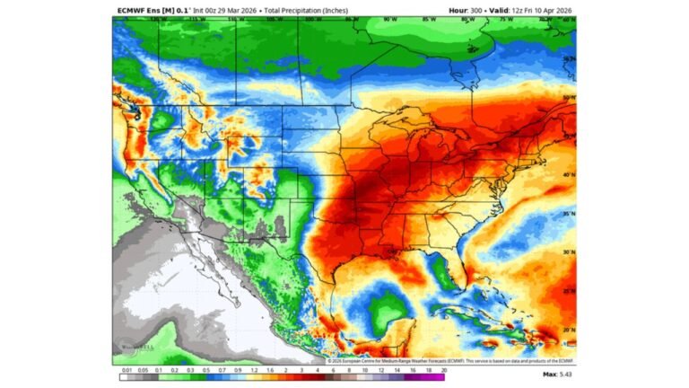
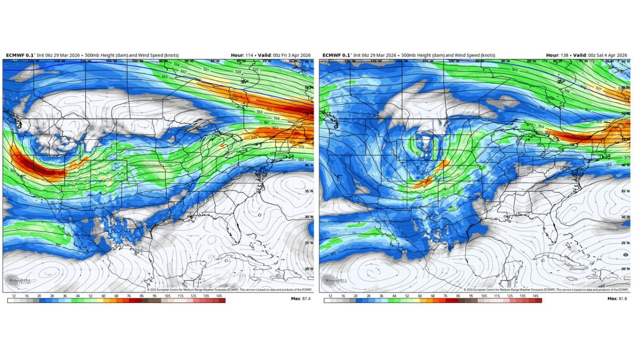
All data is from the ECMWF model initialized March 29, 2026 at 06z.
What Is Happening in the Upper Atmosphere
To understand why this setup matters, it helps to understand what a deepening upper-level trough and closed low actually mean for severe weather.
The atmosphere has layers. What happens miles above the surface directly controls what happens on the ground. When a trough — a dip in the jet stream — pushes southward into the central United States, it drags cold air down from the north while simultaneously pulling warm, moist air northward from the Gulf of Mexico. The collision of those two air masses is where severe weather is born.
When that trough deepens enough to become a closed low — meaning the circulation becomes completely cut off and self-contained rather than just a dip in the jet stream — the storm system becomes more organized, more persistent, and more capable of sustaining severe weather over a larger area for a longer period of time.
That is exactly what the ECMWF is depicting for the April 3–4 window.
Thursday, April 3 — The Trough Arrives
By Thursday evening, April 3, the ECMWF 500mb analysis shows a strong upper-level trough digging southward into the central Plains. The jet stream is focused with maximum wind speeds concentrated over Kansas, Oklahoma, and Missouri, with the energy axis pushing into the Ohio Valley and Tennessee Valley.
This trough position is significant for several reasons. The strongest upper-level winds are positioned directly over the area where Gulf moisture will already be surging northward. That combination — strong upper-level dynamics plus deep surface moisture — is the classic recipe for organized thunderstorm development and severe weather potential across the central United States Thursday afternoon and evening.
The threat area for Thursday centers on Kansas, Oklahoma, Missouri, and Arkansas, with the severe weather potential extending into portions of Illinois, Kentucky, and Tennessee as the system pushes eastward through the evening hours.
Saturday, April 4 — The Closed Low Develops
By Saturday, April 4, the ECMWF shows the trough has deepened significantly into a closed upper-level low centered over the central Plains. This is the more concerning of the two days.
A closed low is a more powerful and organized system than a simple trough. The circulation becomes self-sustaining, pulling energy from a wider area and maintaining its intensity longer. The jet stream energy associated with this system shifts eastward by Saturday, focusing the strongest upper-level winds over the Ohio Valley, Tennessee Valley, and into the Mid-South.
This eastward shift is critical. It means the severe weather threat on Saturday would affect a different and more populated corridor than Thursday — pushing the primary risk area into Tennessee, Kentucky, Indiana, Ohio, Mississippi, Alabama, and potentially Georgia and the Carolinas as the system tracks across the region.
Day-by-Day Threat Breakdown
Thursday, April 3 — Strong upper-level trough arrives over the central Plains. Primary threat area: Kansas, Oklahoma, Missouri, Arkansas. Secondary threat extending into Illinois, Kentucky, Tennessee. Threat type: organized thunderstorms, potential for damaging winds and large hail. Timing: afternoon into evening hours.
Friday, April 4 (overnight into early Saturday) — Trough deepens into closed low. System begins eastward track. Transitional threat period. Rain and storms possible across a wide area from the Plains through the Ohio Valley.
Saturday, April 4 — Closed low fully developed over central Plains. Jet stream energy shifts into Ohio Valley and Tennessee Valley. Primary threat area expands eastward into Tennessee, Kentucky, Indiana, Ohio, Mississippi, Alabama. Threat type: organized severe weather, heavy rain, possible tornado threat depending on surface conditions. Timing: throughout the day and into the evening.
Upper-Level Wind Speed by Region — April 3
| Region | Upper-Level Signal |
|---|---|
| Kansas / Oklahoma | Strongest jet stream energy — primary threat zone |
| Missouri / Arkansas | Strong upper dynamics — significant threat |
| Illinois / Kentucky | Moderate to strong dynamics — secondary threat |
| Tennessee / Ohio Valley | Increasing dynamics through the evening |
| Mississippi / Alabama | Fringe threat Thursday, increasing Friday |
Forecast Confidence Level
High confidence that a significant upper-level trough arrives over the central Plains by Thursday, April 3 — multiple ECMWF runs are consistent on timing and position.
High confidence that the trough deepens into a closed low by Saturday, April 4 — the model has been consistent on this evolution across recent runs.
Medium confidence on exact severe weather coverage and intensity — the surface conditions, storm mode, and exact moisture position will determine how organized and widespread the severe weather threat becomes. These details will sharpen considerably by Tuesday and Wednesday.
Lower confidence on tornado potential specifically — the helicity and surface wind shear data needed to assess tornado risk more precisely will become clearer as the event approaches.
What This Setup Means for Residents
A deepening upper-level trough transitioning into a closed low over a two-day period is not a setup that meteorologists take lightly. It represents a sustained, organized weather system — not a brief passing storm. The severe weather threat with this type of system can last for many hours across a large geographic area rather than moving through quickly.
Residents across Kansas, Oklahoma, Missouri, and Arkansas face the most significant Thursday threat and should monitor updated forecasts closely as the week begins.
Residents across Tennessee, Kentucky, Indiana, Ohio, Mississippi, and Alabama face the Saturday threat window and should have their severe weather plans finalized before the weekend.
Do not wait for a watch or warning to prepare. With a multi-day system like this, preparation done Monday and Tuesday is far more effective than scrambling when watches are issued Thursday afternoon.
Know your shelter location at home, at work, and in your vehicle before this pattern arrives. Interior rooms on the lowest floor, away from windows, are your safest option during tornado warnings.
Have a battery-powered or hand-crank weather radio charged and accessible. Power outages are possible with organized severe weather events of this magnitude.
The Bottom Line
The ECMWF is depicting a two-day severe weather setup across the central and eastern United States centered on Thursday, April 3 and Saturday, April 4. A strong upper-level trough arriving Thursday focuses the initial threat over Kansas, Oklahoma, Missouri, and Arkansas. By Saturday, that trough deepens into a closed low and shifts the primary risk eastward into Tennessee, Kentucky, Indiana, Ohio, Mississippi, and Alabama. This is a setup that warrants serious preparation across a wide swath of the country starting now.
Stay ahead of dangerous weather before it reaches your door. Visit cabarrusweekly.com for daily severe weather coverage, storm alerts, and forecast updates from across the United States — because knowing early is the difference that matters.