Kansas, Oklahoma, Texas, Kentucky, Virginia, Maryland, and New Jersey Face Higher-End Severe Weather Setup Wednesday April 1 as NSSL Machine Learning Model Signals All Severe Modes Possible Across the Plains and Eastern United States
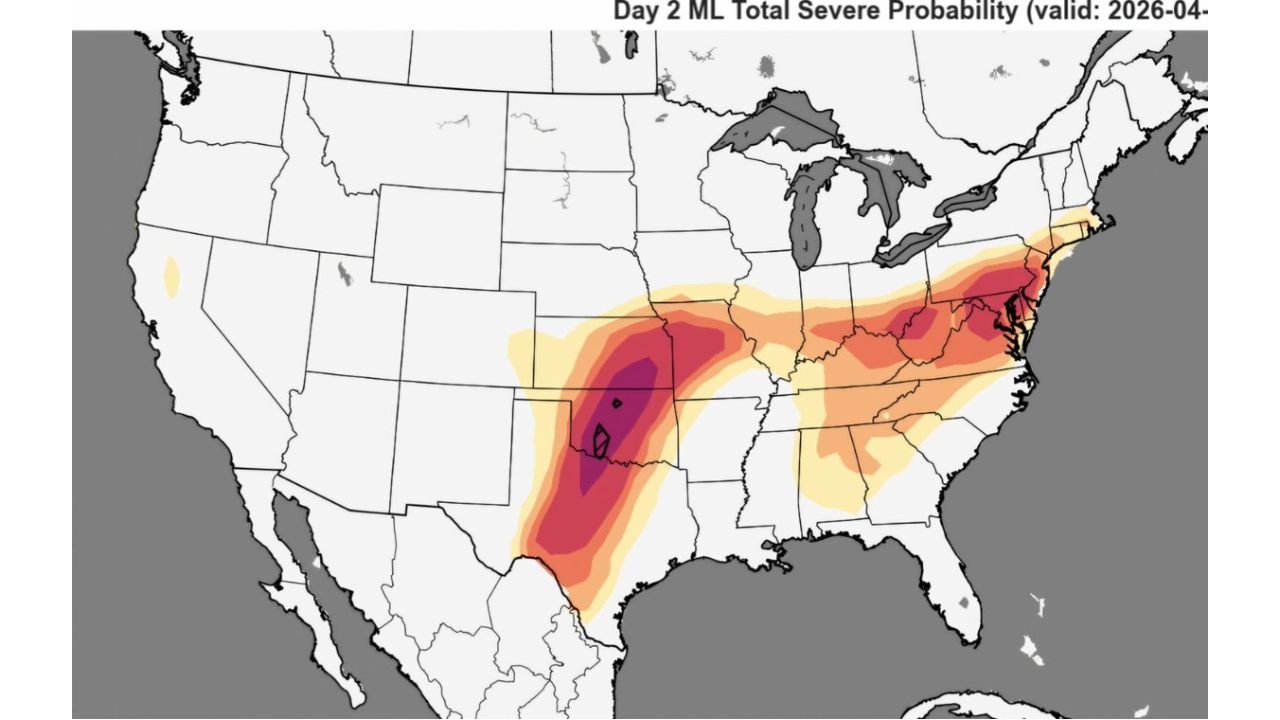
UNITED STATES — The NSSL Machine Learning Severe Weather Model is issuing one of its stronger signals of the spring season for Wednesday, April 1, 2026 — flagging a higher-end severe weather setup across two distinct zones simultaneously. A deep probability core centered over Kansas and Oklahoma represents the primary Plains threat, while a separate and significant severe weather corridor stretches from Kentucky and West Virginia through Virginia, Maryland, and into New Jersey. All severe modes — tornadoes, large hail, and damaging winds — are considered possible across both zones Wednesday.
Two Distinct Threat Zones Wednesday
What makes Wednesday’s setup particularly unusual is the presence of two geographically separated severe weather zones operating simultaneously — one anchored over the southern Plains and one cutting across the Mid-Atlantic and Appalachian corridor.
Zone 1 — The Plains Core
The highest severe weather probability on Wednesday is centered directly over the Kansas and Oklahoma border area — where the ML model is showing a deep purple to black core probability signal. This is the primary tornado and all-hazards severe weather zone Wednesday, consistent with the dryline and supercell setup already well-documented in forecast data. The hatching over this core zone indicates that significant severe weather — including strong tornadoes and very large hail — is considered a realistic outcome for the afternoon and evening hours.
The severe probability extends well beyond the core, spreading southward into Texas and northward through Missouri — placing millions of residents across the southern and central Plains in a zone where severe weather is not just possible but likely during the peak afternoon and evening window.
Zone 2 — The Eastern Corridor
The second zone is less expected but equally significant in the ML model output. A broad swath of elevated severe weather probability stretches from Kentucky and West Virginia northeastward through Virginia, Maryland, Pennsylvania, and into New Jersey. This zone does not carry the extreme core probability of the Plains setup, but the ML model’s signal across this corridor is notable — particularly given the sharp temperature contrast already forecast between the warm air mass in place Wednesday and the cold air surging from the Northeast.
The boundary between these two air masses across the Mid-Atlantic creates the lift and instability needed for severe storm development — and the ML model is clearly detecting that potential across the Eastern corridor.
Severe Probability by Region — Wednesday April 1
| Region | ML Severe Probability Signal |
|---|---|
| Kansas / Oklahoma border | Extreme — deep purple/black core with hatching |
| Northern Texas | Very high — dark red |
| Missouri | High — red to dark red |
| Kentucky / West Virginia | Moderate to high — orange to red |
| Virginia / Maryland | Moderate — orange |
| Pennsylvania / New Jersey | Moderate — yellow to orange |
| Iowa / Illinois | Moderate — orange fringe |
All Severe Modes Possible — What That Means
When forecasters say all severe modes are possible, they mean Wednesday’s atmosphere supports three distinct types of severe weather simultaneously — not just one.
Tornadoes — The supercell environment across Kansas and Oklahoma Wednesday afternoon and evening provides the wind shear and instability needed for rotating storms. The hatched zone over the Plains core signals significant tornado potential. The Eastern corridor carries a lower but non-zero tornado threat with any discrete storm that organizes in the right environment.
Very large hail — Discrete supercells in Wednesday’s environment are capable of producing hailstones of two inches or larger across the Plains core zone. The Eastern corridor also carries a hail threat, particularly across Kentucky, West Virginia, and western Virginia where instability values will be highest.
Damaging straight-line winds — As storm cells organize and mature Wednesday evening, outflow winds and potential bow echo development along the storm line can produce straight-line wind gusts exceeding 70 to 80 mph across a wide area — extending well beyond the immediate tornado and hail threat zones.
Forecast Confidence Level
High confidence on the Plains severe weather threat Wednesday — the ML model, traditional models, and SPC outlooks are all in agreement on a significant severe weather day across Kansas, Oklahoma, and Texas.
High confidence on all severe modes being possible across the Plains core** — the atmospheric ingredients for tornadoes, large hail, and damaging winds are all present simultaneously.
Medium confidence on the Eastern corridor threat** — the ML model signal across Kentucky, Virginia, Maryland, and New Jersey is real but dependent on storm organization and the exact position of the frontal boundary Wednesday afternoon. This zone warrants attention but carries more uncertainty than the Plains core.
What Residents in Both Zones Must Do Before Wednesday Afternoon
Kansas, Oklahoma, and Texas residents face the highest and most certain severe weather risk Wednesday. Shelter plans must be finalized, alert systems must be active, and the sunset window must be treated as the peak danger period — as previously outlined. Do not underestimate this setup.
Kentucky, West Virginia, and Virginia residents — the ML model signal across your region is notable and should not be dismissed. The Eastern corridor threat is real, particularly if discrete storm cells can organize along the frontal boundary Wednesday afternoon. Have a shelter plan ready and keep alerts active through the evening hours.
Maryland, Pennsylvania, and New Jersey residents — your zone carries a moderate severe weather probability Wednesday. While the threat is lower than the Plains core, damaging winds and large hail are possible with any organized storm that moves through the Mid-Atlantic corridor Wednesday afternoon and evening.
Do not assume the Eastern threat is minor simply because the Plains is getting more attention. The ML model does not flag a moderate probability signal across the Mid-Atlantic without sufficient atmospheric justification — this zone deserves the same alert readiness as any other severe weather day.
The Bottom Line
The NSSL Machine Learning Severe Weather Model is signaling a higher-end severe weather day across two separate zones Wednesday, April 1. The Plains core over Kansas and Oklahoma carries the extreme severe probability with all modes — tornadoes, very large hail, and damaging winds — fully in play. A separate Eastern corridor stretching from Kentucky and West Virginia through Virginia, Maryland, and New Jersey carries a significant and notable ML probability signal that residents should not ignore. This is one of the more complex and wide-reaching severe weather setups of the spring season — affecting both the southern Plains and the Mid-Atlantic simultaneously. Stay alert, stay sheltered, and stay informed through Wednesday evening.
Stay ahead of dangerous weather before it reaches your door. Visit cabarrusweekly.com for daily severe weather coverage, tornado outlooks, and storm alerts from across the United States — because knowing early is the difference that matters.