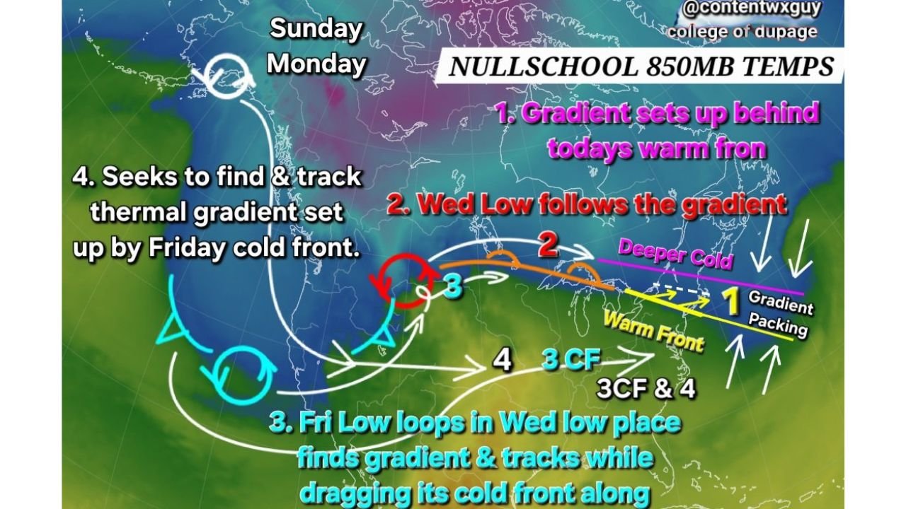
Lake Ontario to Cape Cod Thermal Gradient Sets the Stage for Back-to-Back Storm Tracks from Wednesday Through Sunday
NORTH CAROLINA — A sharpening 850mb thermal gradient stretching from the eastern shore of Lake Ontario to Cape Cod is emerging as the key driver behind multiple storm systems expected to track along the East Coast through the end of the week.
Warm Front Establishes “Nose-Down” Thermal Gradient
Today’s warm front has laid down a pronounced temperature boundary aloft, creating a tight gradient between deeper cold air across southern Canada and warmer air pushing into the Northeast and Mid-Atlantic.
This “nose-down” thermal structure is critical because storm systems tend to follow these gradients. When strong temperature contrasts are present at the 850mb level, they often act as highways for developing lows.
The gradient is currently oriented west-to-east from the Great Lakes toward coastal New England, placing upstate New York, southern Ontario, New England, and the northern Mid-Atlantic near the dividing line.
Wednesday Low Tracks Along the Gradient
The first system expected to take advantage of this setup arrives Wednesday. Model depictions show a surface low riding along the established temperature boundary, tracking from the Upper Midwest toward the Great Lakes and Northeast.
As this low follows the gradient, it reinforces the boundary while dragging colder air southward behind it. That process tightens the thermal contrast even further, priming the region for additional systems.
Communities near Lake Ontario, upstate New York, Vermont, New Hampshire, and Maine will likely sit close to this evolving battleground between cold and warm air.
Friday System Reinforces the Pattern
A second low projected for Friday appears to loop into a similar position as Wednesday’s system, again locating and tracking along the pre-existing gradient.
Importantly, this Friday storm is expected to drag its cold front along a more southern latitude. That repositioning shifts the thermal battleground farther south, potentially influencing areas deeper into the Mid-Atlantic.
This step is crucial because it establishes a new thermal gradient farther south, increasing the potential for subsequent systems to track closer to the coastline.
Sunday Storm May Seek the New Thermal Boundary
By Sunday into Monday, another storm system may develop and track along the newly established gradient. When storms repeatedly reinforce and sharpen these boundaries, later systems can intensify more efficiently.
If the gradient is positioned favorably, areas from the Mid-Atlantic coast northward through New England could see impacts depending on exact storm track and cold air availability.
While North Carolina remains south of the primary Lake Ontario–Cape Cod gradient at this stage, any southward shift in the boundary could bring impacts closer to the region.
Why This Process Matters
Repeated storm tracks along a tightening temperature contrast can amplify coastal systems, particularly when Arctic air remains nearby. Each system modifies the boundary slightly, setting the stage for the next one.
This sequence underscores the importance of monitoring not just individual storms, but the evolving thermal structure guiding them.
Residents along the East Coast should stay attentive as this pattern unfolds through Sunday. Share your local conditions and follow continuing updates at CabarrusWeekly.com as we track this developing multi-storm setup.