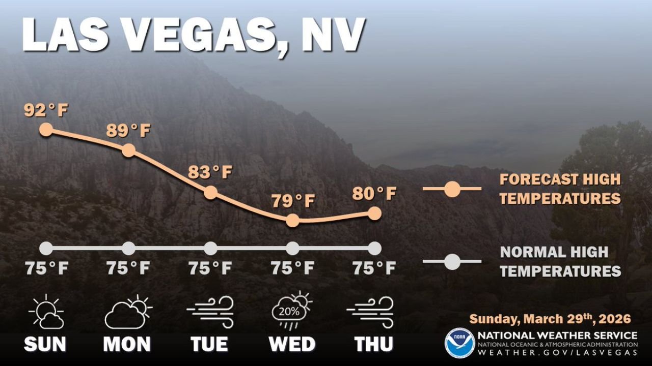
Las Vegas, Nevada, Sees End of Prolonged March Heatwave This Week as Temperatures Drop From 89°F to 79°F With Gusty Winds and Mid-Week Precipitation Chances Returning
LAS VEGAS, NEVADA — The record-breaking March heatwave that pushed Las Vegas temperatures well above seasonal norms is finally coming to an end this week. A more active weather pattern is moving into the region, bringing steadily cooling temperatures, periods of gusty winds, and a mid-week chance of precipitation — a dramatic shift from the oppressive heat that defined the past several weeks across the Southwest.
This forecast was issued by the National Weather Service Las Vegas office on Sunday, March 29, 2026.
How the Week Unfolds in Las Vegas
The cooldown is gradual but consistent — each day this week brings temperatures closer to where late March is supposed to be, even if the city will remain above normal through Thursday.
Monday, March 30 — High of 89°F. Still well above the normal high of 75°F, but the downward trend is already underway. Partly cloudy skies return as the active pattern begins to push into the region.
Tuesday, March 31 — High of 83°F. A noticeable drop from Monday with gusty winds developing across the Las Vegas Valley. The wind will make conditions feel cooler than the thermometer suggests, and residents should expect blowing dust and difficult driving conditions at times during peak gusts.
Wednesday, April 1 — High of 79°F — the coolest day of the stretch and the closest to seasonal norms. A 20% chance of precipitation arrives mid-week as moisture works into the region behind the cooling pattern. Any rainfall would be light but welcome given the extreme dryness left behind by the heatwave.
Thursday, April 2 — High of 80°F. A slight rebound from Wednesday’s low point, but gusty winds return again Thursday. Conditions remain unsettled as the active pattern continues across the Southwest.
Las Vegas Forecast at a Glance
| Day | Forecast High | Normal High | Departure | Conditions |
|---|---|---|---|---|
| Monday, March 30 | 89°F | 75°F | +14°F | Partly cloudy |
| Tuesday, March 31 | 83°F | 75°F | +8°F | Gusty winds |
| Wednesday, April 1 | 79°F | 75°F | +4°F | 20% rain chance |
| Thursday, April 2 | 80°F | 75°F | +5°F | Gusty winds |
Why This Cooldown Matters
Las Vegas hit 92°F on Sunday — 17 degrees above the normal high of 75°F for late March. That kind of temperature in the final days of March is not just unusual for Las Vegas — it is part of the broader historic heat event that drove 17 states across the West and Plains to shatter their all-time March temperature records over the past 10 days.
The return of a more active weather pattern this week signals that the atmospheric ridge of high pressure responsible for locking that extreme heat in place is finally breaking down. As the ridge weakens, cooler air, gusty winds, and moisture can move back into the Southwest — which is exactly what the NWS Las Vegas forecast is showing through Thursday.
Even at 79°F on Wednesday, Las Vegas will still be running 4 degrees above normal — a reminder that while the heatwave is ending, its thermal footprint does not disappear overnight. The atmosphere takes time to fully reset after a prolonged heat event of this magnitude.
What the Gusty Winds Mean for Residents
Two of the next four days — Tuesday and Thursday — carry gusty wind conditions across the Las Vegas Valley. Wind gusts in the desert Southwest during active pattern transitions can be significant, and residents should be prepared.
Secure any outdoor furniture, decorations, or lightweight items before Tuesday and Thursday mornings. Gusty conditions in the Las Vegas area can develop quickly and move objects that seemed secure under calm conditions.
Expect blowing dust on gusty days — visibility can drop rapidly in open areas and on desert highways during the strongest gusts. Drivers should reduce speed and increase following distance when blowing dust is present.
Outdoor plans on Tuesday and Thursday should account for wind — conditions at higher elevations in the surrounding Spring Mountains and Red Rock Canyon area will be more intense than in the valley floor.
Forecast Confidence Level
High confidence on the overall cooling trend through the week — the pattern change driving temperatures down is well-established and consistent across model data.
High confidence on gusty wind conditions Tuesday and Thursday — the wind signal is clear in the NWS forecast.
Medium confidence on Wednesday precipitation** — the 20% chance reflects genuine uncertainty. A light shower is possible but not guaranteed. Most of the Las Vegas Valley could stay dry even if precipitation develops somewhere in the region.
The Bottom Line
Las Vegas is finally turning the corner on one of the most extreme March heat events on record. Temperatures will drop from 89°F Monday to a weekly low of 79°F Wednesday — still above normal, but a significant and welcome retreat from the 90-plus degree heat that has dominated the Southwest for weeks. Gusty winds on Tuesday and Thursday and a 20% precipitation chance Wednesday round out a week that looks nothing like the record-breaking heat that preceded it. The heatwave is ending — but the active pattern moving in brings its own set of conditions to prepare for.
Stay ahead of dangerous weather before it reaches your door. Visit cabarrusweekly.com for daily forecasts, heat alerts, and weather updates from across the United States — because knowing early is the difference that matters.