Late Next Week Into Mid April Window Shows Expanding Heavy Rain Zone from Texas to Midwest as Warmer Pattern Builds Nationwide
UNITED STATES — A more active and increasingly wet weather pattern is expected to take hold across large portions of the country over the next two weeks, with forecast models pointing to widespread rainfall totals and a gradual shift toward warmer conditions.
New data from high-resolution and ensemble guidance indicates that multiple rounds of rain and storms will continue, especially across the central United States, before a broader warm pattern expands nationwide.
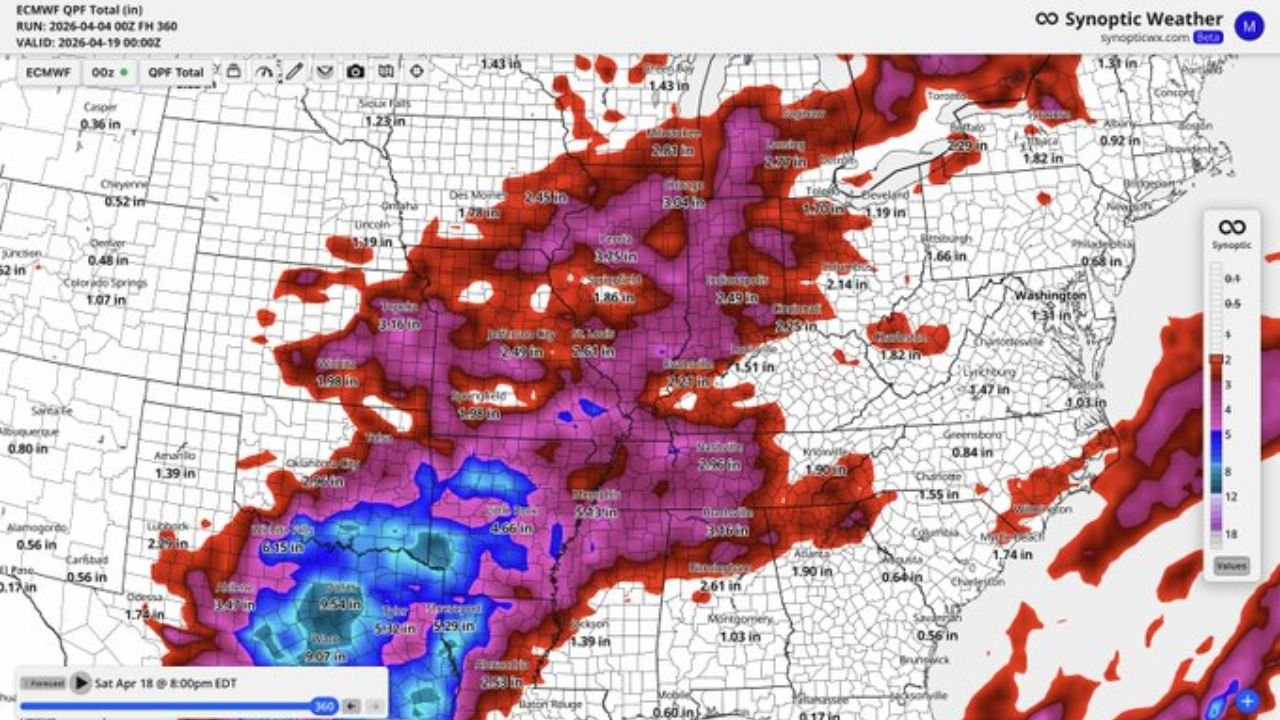
Heavy Rain Corridor Setting Up from Texas to the Midwest
The latest projections highlight a clear zone of heavier rainfall stretching from:
- North Texas and Oklahoma
- Through Arkansas and Missouri
- Into Illinois, Iowa, and parts of the Great Lakes
Within this corridor:
- Many areas are expected to receive 2 to 4 inches of rain
- Some localized zones, particularly in Texas and surrounding regions, could exceed 5 to 7 inches
This pattern suggests repeated storm systems tracking over similar areas, increasing the risk of accumulating rainfall totals over time.
Why the Pattern Stays Active
The ongoing wet setup is being driven by:
- Persistent storm tracks across the central U.S.
- Continued moisture flow from the Gulf of Mexico
- Slow-moving systems that allow rainfall to build over multiple days
Because of this, the pattern is not a one-day event but rather a prolonged stretch of unsettled weather, which can gradually increase flooding concerns in vulnerable locations.
Midwest and Great Lakes Also See Significant Totals
Farther north, the Midwest and Great Lakes are also expected to see consistent rainfall.
Cities and regions including:
- Chicago, Illinois
- Des Moines, Iowa
- Indianapolis, Indiana
- Detroit, Michigan
could experience 2 to 3+ inches of rain, with locally higher amounts where storms repeatedly track.
This continued rainfall may lead to:
- Saturated ground conditions
- Rising river and stream levels
- Slower drainage in urban areas
Warm Pattern Begins Expanding Nationwide
Alongside the active storm track, a more persistent warm pattern is expected to develop, especially:
- Late next week
- Continuing into the second week of April
Temperature outlooks show:
- Above-normal warmth spreading across much of the U.S.
- Stronger signals of sustained warmth across the South and East
This shift indicates that while rain remains frequent, spring-like temperatures will begin to dominate more consistently.
What This Means for the Coming Weeks
The combination of frequent rainfall and increasing warmth signals a transition deeper into spring across much of the country.
Key impacts include:
- Improved soil moisture in some regions
- Potential delays in outdoor activities due to wet conditions
- Increasing attention toward planting season timing
With warmer air settling in, conditions may become more favorable for seasonal changes, but the ongoing rain pattern will need to be monitored closely.
Looking Ahead: A Busy but Transitional Pattern
Overall, the next two weeks point toward:
- A wet and active central U.S. weather pattern
- Gradually increasing temperatures nationwide
- Continued storm opportunities across multiple regions
This is a classic spring transition phase where rainfall and warmth begin to overlap, creating both benefits and challenges depending on location.
Stay Updated With Cabarrus Weekly
For continued updates on rainfall trends, storm patterns, and evolving spring weather across the United States, stay connected with Cabarrus Weekly. Share this update with others tracking changing conditions and follow along as this active weather pattern develops.