Late-Weekend Winter Storm Signal Strengthens for Pennsylvania, New York, New Jersey, Connecticut, and Massachusetts as Ensemble Trends Focus Snow Risk Inland
NORTHEASTERN UNITED STATES — Confidence is gradually increasing that a winter storm will impact parts of the Northeast late next weekend, with ensemble trends now consistently showing a developing system and a more defined zone where accumulating snow appears most likely.
Ensemble Trends Show Storm Signal Gaining Traction
Recent ensemble guidance continues to trend toward a legitimate storm threat late next weekend, with growing agreement that a surface low will track close enough to bring impactful winter weather somewhere in the region. While individual model solutions still vary on exact placement, the overall signal has strengthened enough to suggest this is no longer a low-confidence or fringe scenario.
Forecasters note that confidence has shifted away from whether something develops to where the most meaningful impacts set up.
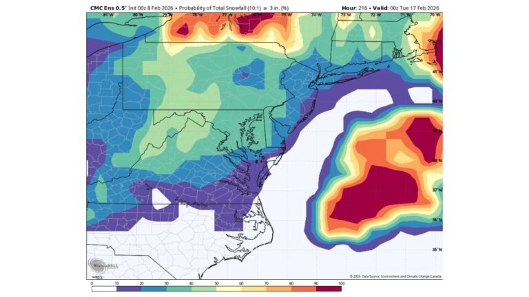
Inland Track Favors Accumulating Snow Away From the Immediate Coast
Probability maps highlight the highest chances of accumulating snow inland, rather than directly along the coast. The most favored zone currently stretches from central and northern Pennsylvania through upstate New York and into interior New England, where colder air is more likely to hold as the system evolves.
Coastal areas from New Jersey through eastern Massachusetts remain more sensitive to storm track and thermal profiles, increasing the risk for mixed precipitation or rain closer to the shoreline.
Best Snow Potential Focuses on Interior Northeast
Based on current shading and probability guidance, the corridor with the best chance for meaningful snowfall includes parts of:
• Central and northern Pennsylvania
• Interior New York
• Western and central Massachusetts
• Interior Connecticut
These areas sit within the zone where ensemble members most frequently overlap colder air with sufficient moisture, a key requirement for accumulating snow at this range.
Still a Track-Sensitive Setup With Room for Change
Despite improving confidence, this remains a highly track-dependent system. Small adjustments north or south could shift the snow axis significantly, especially near transition zones where temperatures hover close to freezing.
Forecasters caution that confidence in specific totals or city-by-city impacts remains low, but the increasing agreement on a storm signal itself is notable this far out.
What to Watch Going Forward
Key factors to monitor over the coming days include storm timing, low-pressure track, and cold air availability across the interior Northeast. If ensemble trends remain stable or tighten further, confidence in a more impactful winter storm will continue to grow.
For now, the message is clear: a late-weekend winter storm is increasingly likely somewhere in the Northeast, and attention should be on inland areas for the best snow potential.
If you live in the Northeast and are tracking this system, we want to hear from you. Share your local expectations and stay tuned for continued updates at CabarrusWeekly.com.