Light Snow Spreads Across Upstate New York and Interior Northeast Sunday Night While New York City and Philadelphia See Mostly Rain
NEW YORK AND THE NORTHEAST — A late-weekend system will bring light snowfall to interior portions of New York and the Northeast Sunday night, while major coastal cities including New York City and Philadelphia remain largely on the rain side of the storm.
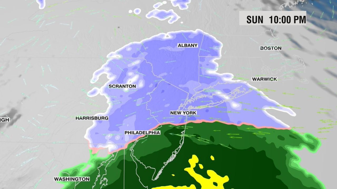
Forecast guidance for Sunday at 10:00 PM shows the steadier snow shield positioned well north of the Interstate 95 corridor.
Snow Focused Farther North
The heaviest concentration of snow Sunday night appears centered over Albany and surrounding upstate New York communities, extending west toward Scranton and into interior sections of the state.
Snow coverage spreads across much of central and northern New York, with lighter amounts stretching into parts of interior southern New England. The setup suggests a broad but generally light snowfall event rather than a high-impact winter storm.
Accumulations look modest at this time, with the northern tier most likely to see measurable snow.
Rain Dominates Along I-95 Corridor
Farther south, a clear rain-snow line is positioned near or just north of New York City and Philadelphia.
Both metro areas appear to remain primarily in the rain zone, with steady precipitation expected but temperatures too warm to support significant snowfall. Areas south toward Washington, D.C. are firmly in the rain sector.
This sharp gradient between snow and rain highlights how marginal temperatures are across the region.
Coastal Southern New England Mostly Rain
Communities closer to the coast, including areas near Warwick and Boston, appear largely on the rain side of the system Sunday night.
While interior elevations could briefly mix with wet snow, coastal zones should experience mainly rain as milder air wraps into the system.
What This Means for Travel
For travelers heading across upstate New York Sunday evening, light snow and reduced visibility may develop, especially north of the New York City metro.
Road impacts should remain limited given the lighter intensity, but untreated surfaces could become slick in colder inland areas.
Meanwhile, major airports along the I-95 corridor are more likely to contend with rain rather than snow, reducing the risk of widespread winter-weather delays.
We’ll continue monitoring the exact placement of the rain-snow line as temperatures fluctuate Sunday evening.
If you’re seeing snow in Albany, Scranton, or interior New York — or rain in New York City and Philadelphia — share your conditions with us at CabarrusWeekly.com.