Louisiana, Mississippi, Alabama and Texas Lead Early 2026 Tornado Reports as EF-2 Twisters Already Confirmed in Multiple Counties
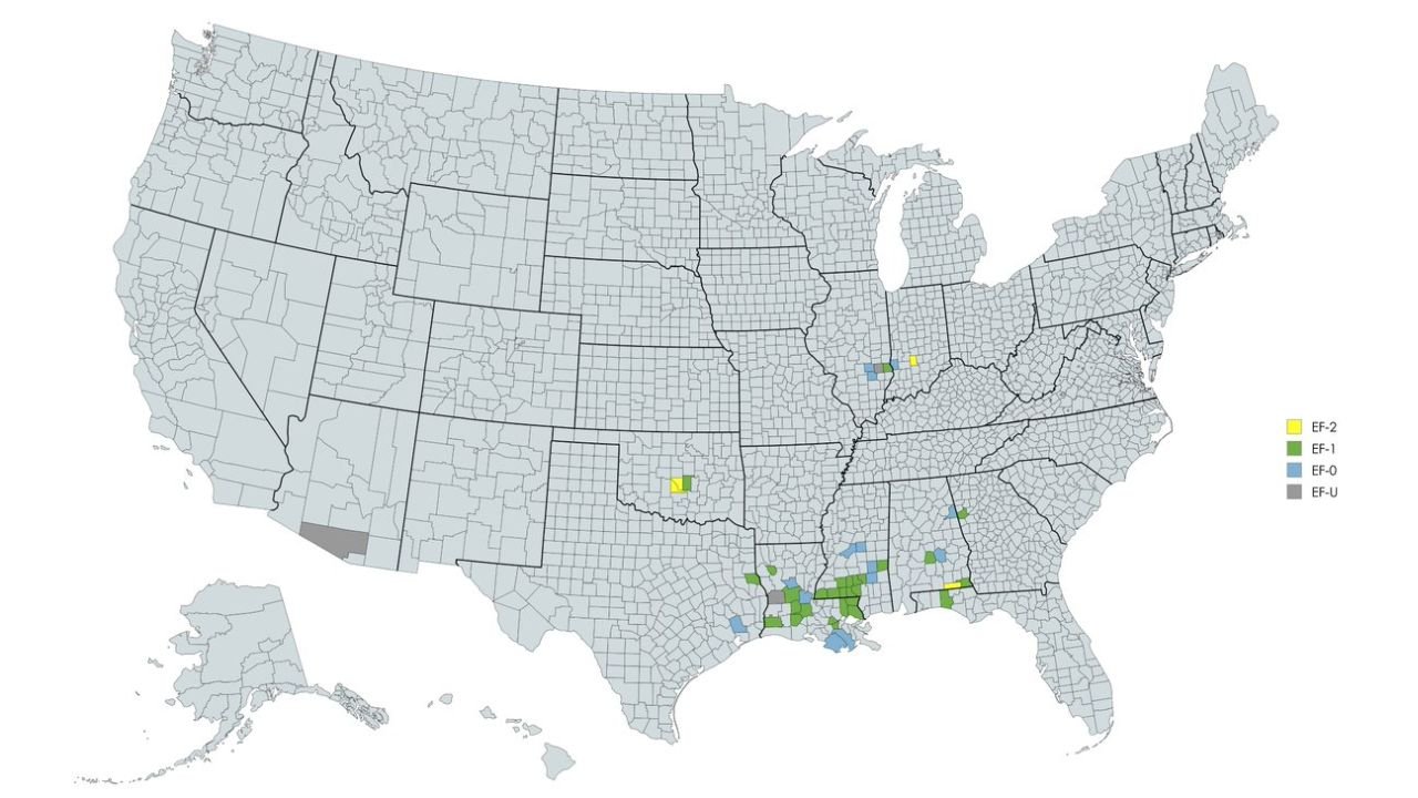
UNITED STATES — The strongest-rated tornadoes recorded in each U.S. county so far in 2026 reveal a clear early-season focus across the Lower Mississippi Valley and Gulf Coast states, with Louisiana, Mississippi, Alabama, and parts of Texas showing the most concentrated activity as of February 21.
While much of the country remains tornado-free or only seeing weaker classifications, several counties across the Deep South have already experienced tornadoes rated EF-1 and EF-2.
EF-2 Tornadoes Already Confirmed in Southern Counties
According to the county-by-county breakdown, EF-2 tornadoes (yellow shading) have been confirmed in select areas, including parts of Texas and the Lower Mississippi Valley region.
EF-2 tornadoes are capable of producing wind speeds between 111–135 mph, strong enough to cause considerable structural damage, uproot trees, and heavily damage mobile homes.
These stronger ratings stand out against a backdrop of mostly EF-0 and EF-1 tornadoes elsewhere.
Louisiana and Mississippi Show Highest Concentration
The densest cluster of tornado reports so far in 2026 appears across southern Louisiana and southern Mississippi, where multiple counties show tornado ratings ranging from EF-0 (blue) to EF-1 (green).
Additional activity extends into southern Alabama, with scattered reports also appearing across portions of Georgia.
This early-year concentration aligns with typical winter severe weather patterns that often favor the Gulf Coast and Deep South.
Isolated Activity in Texas and the Mid-South
Parts of eastern and central Texas have also recorded tornado activity, including at least one county reporting an EF-2 event.
Scattered tornado reports have appeared farther north into portions of the Mid-South and Ohio Valley, though most counties in those regions show limited or no confirmed tornado ratings so far this year.
Much of the U.S. Remains Quiet — For Now
Large portions of the West Coast, Great Plains, Upper Midwest, Northeast, and much of the Rockies remain shaded in gray, indicating either no tornado activity or only unrated/weak events through February 21.
This distribution reflects the typical seasonal pattern, where the most active severe weather zones in winter often center on the Gulf states before expanding northward later in spring.
Early Season Reminder for Preparedness
Although tornado season is still ramping up, the early presence of EF-2 tornadoes underscores that severe weather can strike well before the traditional April and May peak.
Residents across Louisiana, Mississippi, Alabama, Texas, and Georgia should remain prepared as we move deeper into late winter and early spring, when severe weather frequency historically increases.
For ongoing severe weather coverage and preparedness updates, visit CabarrusWeekly.com and share reports from your community.