Major Snowstorm Uncertainty Grows for Washington, D.C. to Boston as GFS Projects 30+ Inches While Euro Shows Minimal Accumulation
NORTH CAROLINA — A dramatic split between two major forecast models is raising eyebrows in the meteorological community, with one projecting over 30 inches of snow near Washington, D.C., while another shows only light, melting snowfall across the same region.
Euro Model Shows Limited Snowfall for D.C.
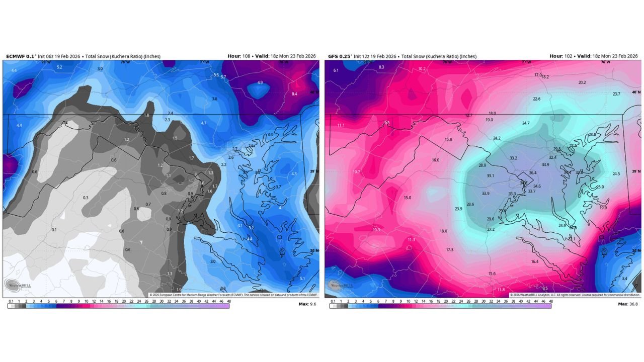
The 06z European model (ECMWF) depicts a relatively modest snowfall outcome across the Mid-Atlantic. Totals around Washington, D.C. and much of central Maryland remain near 1 inch or less, with slightly higher accumulations confined to northern areas.
Across parts of Pennsylvania and into New York, snowfall increases modestly, but the core Mid-Atlantic urban corridor from D.C. through Baltimore shows limited accumulation in this solution.
This scenario would imply either a warmer storm track, quicker changeover to rain, or a more offshore system limiting heavy snow development inland.
GFS Paints a Much Different Picture
In stark contrast, the 12z GFS model delivers a much more aggressive solution. The model projects a significant snowfall bullseye centered near Washington, D.C., with widespread totals exceeding 30 inches in parts of Maryland and northern Virginia.
Snowfall gradients expand northward toward Philadelphia and New York, while interior sections of Pennsylvania and upstate New York also receive heavy accumulation in this solution.
The difference between near-melting snowfall and nearly three feet of accumulation highlights an extraordinary level of forecast uncertainty for a system that is not far out in time.
Washington, D.C. to Boston Corridor in Focus
Both models show some degree of impact from Washington, D.C. through Boston, but the magnitude differs drastically.
The Euro supports a more modest event, likely in the 6–12 inch range for parts of the Northeast, with lower totals closer to the Mid-Atlantic coast. Meanwhile, the GFS suggests a historic-scale storm centered near the D.C. metropolitan region, with heavy snow extending northward.
Such a discrepancy suggests differences in:
Storm track positioning
Thermal profile and surface temperatures
Strength and placement of coastal low development
Even small shifts in these factors can dramatically alter snowfall totals in coastal storm setups.
Why the Models May Be Diverging
Model disagreements of this magnitude often stem from how each handles:
Upper-level energy phasing
Cold air placement ahead of the storm
Coastal redevelopment timing
If cold air is more entrenched and the storm tracks slightly inland before strengthening, heavier snow would spread farther south and west. If the system tracks farther offshore or warmer air intrudes, snowfall would be sharply reduced near D.C.
This type of setup, especially along the I-95 corridor, is notoriously sensitive to minor adjustments.
What This Means for North Carolina
While the heaviest snow threat is focused well north of Cabarrus County, this evolving storm track still matters locally.
North Carolina’s role in this system will likely involve:
Rainfall potential as the storm develops offshore
Gusty winds along frontal passage
Cooler air filtering in behind the system
At this time, there is no indication of major snowfall impacts for central North Carolina, but the broader East Coast pattern remains active.
Forecast Confidence Remains Low
When two leading global models show such radically different snowfall outcomes within a similar timeframe, it underscores the need for caution.
Ensemble guidance and additional model runs will be critical in narrowing the range of possibilities. It is entirely possible that the eventual outcome lands somewhere between the two extremes.
For residents along the Mid-Atlantic and Northeast corridor, close monitoring is essential in the coming days.
We will continue tracking how this system evolves and what it may mean for broader East Coast impacts. Share your local conditions and stay updated with the latest weather developments at CabarrusWeekly.com.