March 5 Severe Setup Trending Strong on GEFS as Southern Plains From Central Texas to Oklahoma Show Increasing Tornado-Favorable Signals
UNITED STATES — Ensemble guidance continues to trend upward for a potentially significant severe weather setup across the Southern Plains around March 5, with model signals increasingly favoring central and north Texas into southern Oklahoma as the corridor to watch.
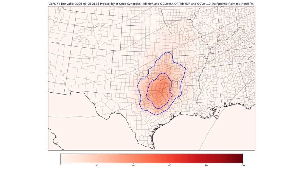
Recent GEFS runs show a notable expansion in probabilities for favorable severe-weather synoptics across portions of central Texas, north-central Texas, and southern Oklahoma, marking the first strong-looking Southern Plains signal of the year.
Increasing Probability of “Good Synoptics”
Probability maps highlight a concentrated zone centered over:
- Dallas–Fort Worth Metroplex
- Waco and Austin areas
- Extending north toward southern Oklahoma
Ensemble probabilities for favorable large-scale ingredients — including sufficient deep-layer shear and adequate moisture return — have increased compared to prior runs.
The highest clustering of favorable signals currently sits across north-central Texas, suggesting this region may be near the primary warm-sector target if trends continue.
Moisture Return Appears Adequate
Dewpoint guidance shows 60°F dewpoints pushing northward from the Gulf Coast into central and east Texas.
The blue contour marking the 60°F threshold arcs from the Texas Gulf Coast inland through central Texas and into eastern Texas, a key ingredient for robust thunderstorm development in early March.
While the deepest moisture remains closer to the coast, ensemble means support at least modest Gulf return into the interior Southern Plains — often enough when combined with strong dynamics.
Steep Lapse Rates and Lift Overhead
Mid-level lapse rate fields show favorable instability developing across western and central Texas, especially along and west of the Interstate 35 corridor.
Additionally, QG ascent contours (indicative of upward motion) are positioned near the developing warm sector. The overlap of:
- Increasing moisture
- Favorable lapse rates
- Large-scale ascent
is one reason forecasters are beginning to take a closer look at this setup.
Western Trough Driving the Setup
Upper-level guidance indicates a trough digging across the Southwest and southern Rockies before ejecting eastward.
As that system advances, it promotes:
- Strengthening low-level flow from the Gulf
- Increasing vertical wind shear across Texas and Oklahoma
- Surface cyclogenesis across the Southern Plains
This classic early-season configuration often supports organized severe thunderstorms if instability is sufficient.
What Could Limit the Threat?
It remains several days out, and important questions remain:
- How far north will quality moisture advance?
- Will storms remain discrete, or quickly consolidate into a line?
- Will cloud cover limit surface heating?
Early March systems can be highly dynamic but sometimes moisture-limited. Even so, this is the first setup this year where ensemble support appears robust enough to raise eyebrows among forecasters.
Bottom Line
While details will evolve, central and north Texas into southern Oklahoma currently appear to be the zone most likely to see organized severe thunderstorms around March 5.
Residents across Dallas, Fort Worth, Waco, Austin, and southern Oklahoma communities should monitor forecast updates in the coming days as confidence continues to build or adjust.
Stay with CabarrusWeekly.com for continued analysis as this potential Southern Plains setup develops.