Massachusetts, Connecticut and Rhode Island Face a Sharp Arctic Blast Saturday With Squally Snow Bands and Dangerous Wind Chills
UNITED STATES — An Arctic blast is expected to surge into Southern New England on Saturday, arriving first in the west and spreading east as winds ramp up sharply and temperatures and wind chills drop fast, creating a setup where snowfall totals could vary wildly from town to town.
Why This Setup Is So Tricky
This pattern is difficult because the snow isn’t expected to be one steady, uniform shield. Instead, the guidance points to bursts and bands that can briefly become intense as the Arctic front pushes through. That means one community may pick up a quick several inches while a neighboring town ends up with much less, even over a short distance.
Forecasters are also watching the potential for ocean-enhanced snow near the Massachusetts coast, and for a narrow, focused band tied to an inverted trough as low pressure develops to the south—features that are notoriously hard to pin down until close to the event.
Snow Timeline From Friday Afternoon Through Saturday
The first snow concern may actually begin Friday afternoon with the chance of ocean-effect snow across eastern coastal Massachusetts. From there, light snow is expected to move in Friday evening from the west, ahead of the incoming Arctic front.
Snow showers then continue Friday night into Saturday, and the most volatile period appears to be Saturday morning, when the Arctic air arrives and can cause the snow to enhance quickly in spots. In the strongest bursts, snow may turn squally, with short-lived but locally heavy snowfall and near-whiteout visibility.
By Saturday afternoon, snow should trend more scattered, but it can still be locally heavy where bands persist, all while temperatures fall and winds increase.
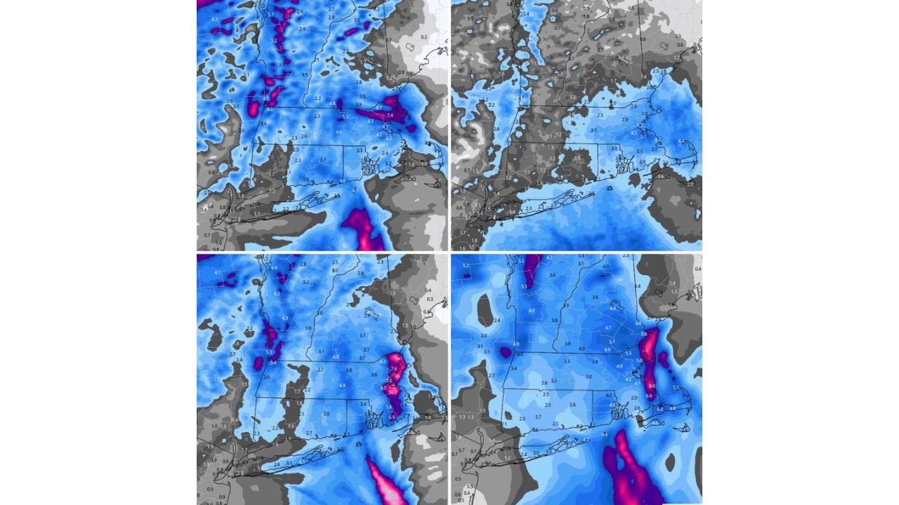
Expected Snowfall Range and Where Higher Totals Are Most Likely
The current idea is widespread 1–3 inches across Southern New England, but with local amounts up to around 6 inches where the most intense bands set up. The key message is not the average—it’s the potential for sharp gradients, where totals change dramatically within a few miles.
Areas being highlighted as having a better chance to reach 3 inches or more include the Berkshires in Massachusetts south into far northwest Connecticut, and eastern coastal Massachusetts including Cape Cod and the islands. There is also a lower-confidence signal that a narrow stripe of heavier snow could extend into eastern Connecticut or Rhode Island, but confidence in that placement remains lower because the band could wobble significantly.
Wind, Blowing Snow, and a Rapid Temperature Drop
Even where totals stay modest, impacts can spike quickly because the Arctic front is expected to arrive with gusty winds and a noticeable drop in temperature through the day Saturday. That combination can lead to blowing snow, reduced visibility in open areas, and slick travel—especially if a heavier burst hits right as temperatures are falling.
The most hazardous travel window may be during the Saturday morning push, when snow intensity and wind can briefly overlap, and roads can change fast.
What Residents Should Watch for Saturday
The biggest concern isn’t just “how many inches.” It’s whether your town gets under one of the narrow, fast-hitting bands that can dump snow quickly, followed by blowing snow and rapidly worsening cold. If you have Saturday morning plans, be ready for conditions that can swing from manageable to difficult in a short period of time, especially across Massachusetts, Connecticut, and Rhode Island.
What are conditions like where you are—are you seeing steady snow, brief squalls, or blowing snow as the cold rushes in? Share what you’re experiencing, and keep checking CabarrusWeekly.com for continuing updates as this complex setup evolves.