Mid-Atlantic and Northeast Winter Storm Signal Builds for Feb. 14–16 as ECMWF Ensembles Hint at Snow Into Virginia and North Carolina
UNITED STATES — A longer-range winter signal remains on the board for the Feb. 14–16 window across the Mid-Atlantic and Northeast, with ensemble pattern maps favoring a setup that could support another round of wintry precipitation. The key message right now is confidence in the pattern—not the exact storm track—meaning this is still a “watch the trend” situation rather than a locked-in forecast for any one town.
Why the Feb. 14–16 Window Keeps Showing Up
Ensemble guidance continues to advertise a storm-friendly background pattern next weekend, and that’s why this timeframe keeps getting highlighted. The upper-air maps show a blocking look over the North Atlantic, which can slow down systems and keep colder air involved on the East Coast.
At the same time, the discussion notes that with a west-based NAO block and a strong -PNA, a flatter, faster-moving system may be more likely than a highly amplified coastal bomb. That matters because a flatter system can still produce snow, but it often narrows the corridor of heavier totals and increases the “fine line” between a cold rain and accumulating snow.
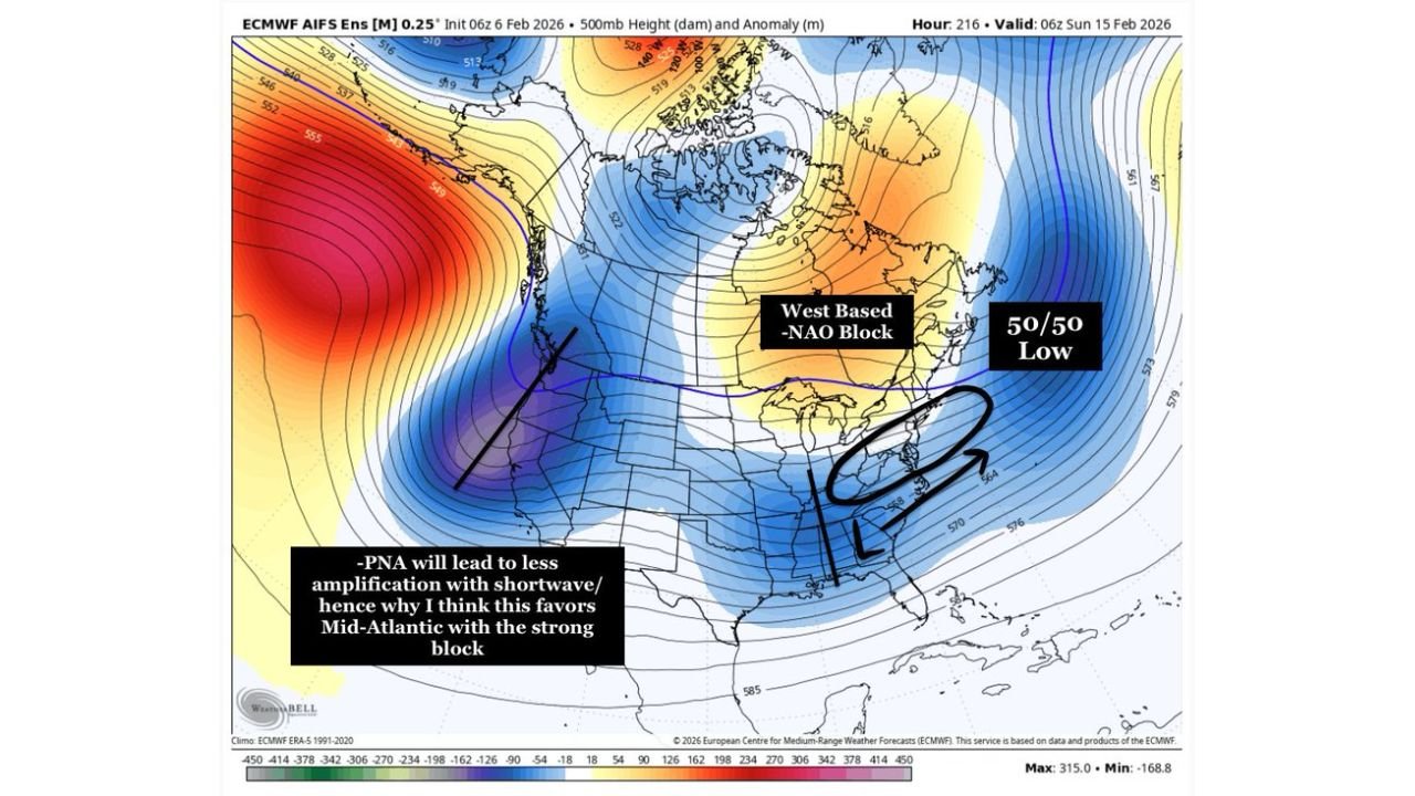
What the Upper-Air Pattern Is Suggesting
The 500mb ensemble map highlights two classic features winter forecasters watch closely: a blocking signal (labeled as a west-based NAO block) and a “50/50 low” region over the North Atlantic that can help maintain a colder pattern downstream.
When those features are present, the Mid-Atlantic has a better chance to stay on the cold side of a storm track—especially inland. The tradeoff is that a strong Pacific pattern like -PNA can reduce amplification, keeping storms more progressive and making it harder for a single system to deepen dramatically as it moves up the coast.
Where the Best Snow “Signal” Currently Sits
The 72-hour snow ensemble graphic shows the most consistent snow footprint from parts of the Mid-Atlantic into the interior Northeast, with a broader area of light-to-moderate totals and a few embedded pockets that stand out.
What’s notable for Cabarrus Weekly readers is that the snow shading extends southwest far enough to include Virginia and reaches toward North Carolina, suggesting at least some potential for wintry weather on the southern edge of the storm. In these setups, small shifts in storm track and cold-air placement can decide whether central North Carolina sees a light event, a mix, or mostly rain.
What This Could Mean for Virginia and North Carolina
If this pattern holds, Virginia sits closer to the heart of the “snow-friendly” zone, which is why it’s being watched as a higher-probability impact area. North Carolina, meanwhile, looks like it could be closer to the southern gradient where outcomes are typically more variable.
For the Piedmont—where marginal temperatures are common—the most important detail is timing and cold air delivery. If the cold locks in ahead of the moisture, snow becomes more plausible. If the cold arrives late, the same system can trend wetter with less accumulation potential. Right now, the guidance supports keeping snow in the conversation for Virginia and at least some wintry potential for North Carolina, but it’s too early to assign specific amounts to counties.
Why Confidence Is Limited Right Now
Even though the signal is “clearly there,” the same guidance emphasizes it’s still just a signal, and that it’s not time to obsess over individual operational model runs. That’s the correct approach at this lead time, because operational runs can swing wildly while ensembles quietly hold the more important idea: whether the pattern favors a storm at all.
In other words, the forecast challenge isn’t just “will a system exist?”—it’s where the storm track sets up, how quickly it moves, and where the sharpest gradient lands. In a flatter-flow setup, the heaviest snow axis can shift enough that locations only a county or two apart experience very different outcomes.
What Cabarrus County Should Watch Over the Next Few Updates
For Cabarrus County and the surrounding North Carolina Piedmont, the smartest indicator to track is not a single snowfall map—it’s whether the cold pattern remains in place as we get closer to next weekend. If future runs keep the cold anchored and continue showing a storm window, that’s when local impacts become a more realistic discussion.
If this signal strengthens, the first local “tell” will be whether guidance begins to consistently show wintry precipitation reaching deeper into North Carolina rather than staying mainly in Virginia and farther north. If that trend appears, then the conversation shifts from “pattern watch” to “impact watch.”
If you’re following this Feb. 14–16 signal too, tell us what you’re seeing where you live—and what you want us to focus on next (snow potential, timing, or travel impacts). Share your thoughts and stay with CabarrusWeekly.com for the next update as the forecast moves into a more reliable range.