Mid-March Pattern Flip Shows Warm, Dry Ridge Building Over California, Nevada and Utah While Storm Track Digs Into Midwest and East
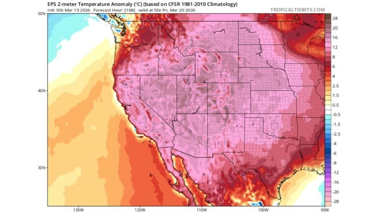
UNITED STATES — A pronounced shift in the upper-level pattern is signaling a ridge-over-the-West, trough-over-the-East setup by mid-March, bringing warm and dry conditions to the Intermountain West while directing cooler, more unsettled weather into the Midwest and Eastern U.S.
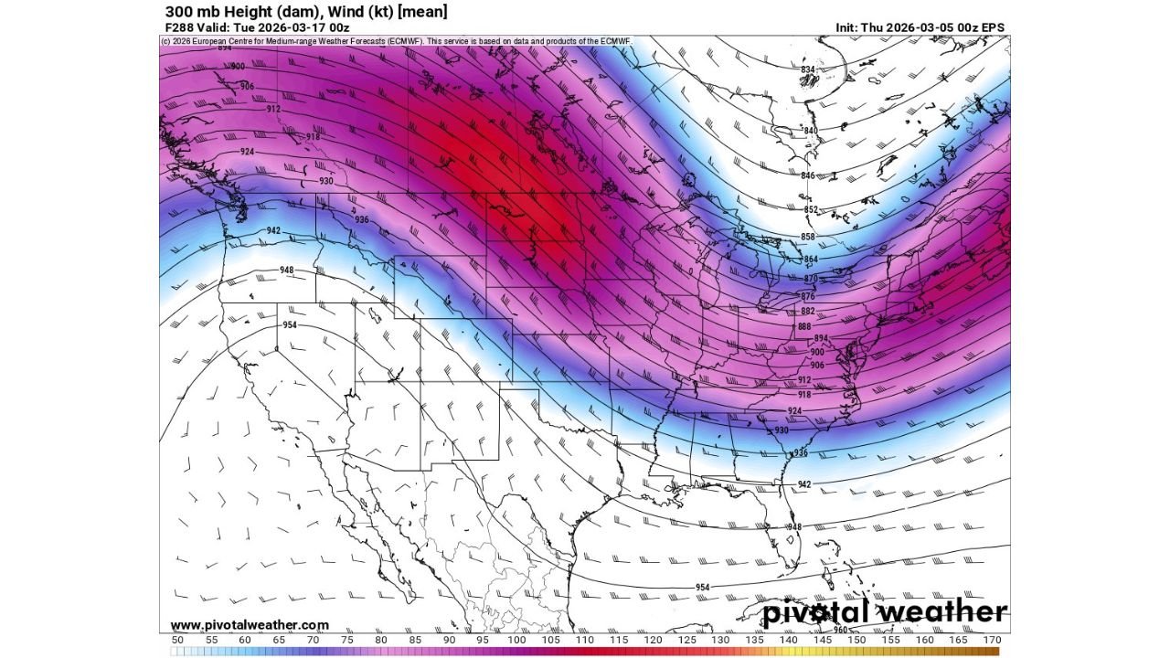
Long-range upper-air guidance valid around March 17 shows a strong jet stream configuration carving sharply across the country.
Strong Ridge Anchors the West
The 300 mb height and wind pattern indicates a broad ridge centered over:
- California
- Nevada
- Utah
- Arizona
- Portions of Idaho and western Colorado
This configuration favors:
- Above-normal temperatures
- Limited precipitation
- Suppressed storm activity
- Reduced snowfall across the higher elevations
The orientation of the flow suggests northerly to northwesterly components east of the ridge, which can limit Gulf moisture transport into the western states.
In practical terms, much of the Intermountain West could see a stretch of dry and possibly very warm mid-March weather, with minimal opportunities for significant snow.
Deep Trough Carves Into the Midwest and East
Meanwhile, a strong trough digs across:
- The Northern Plains
- The Upper Midwest
- The Great Lakes
- The Ohio Valley
- The Mid-Atlantic and Northeast
States potentially influenced by this cooler, more active pattern include:
- Minnesota
- Wisconsin
- Michigan
- Illinois
- Indiana
- Ohio
- Pennsylvania
- New York
- Virginia and the Carolinas
This trough configuration supports:
- Cooler air spilling southward
- Active storm systems tracking through the central and eastern U.S.
- Continued precipitation chances east of the Mississippi River
The jet stream appears strongest from the Northern Plains into the Great Lakes and Northeast, signaling ongoing energy and storm development in those regions.
Gulf Moisture Likely Limited Westward
Another notable feature of this setup is the positioning of the jet and upper-level flow, which may:
- Keep deeper Gulf moisture largely confined to the central and eastern states
- Limit northward and westward moisture return into the Rockies and Great Basin
That reduces meaningful precipitation opportunities across states such as:
- Nevada
- Utah
- Arizona
- Interior California
“Feast or Famine” Pattern Continues
This evolving mid-March setup reinforces a broader seasonal theme of sharp regional contrasts:
- Dry and warm conditions across the western U.S.
- Continued storm potential across the Midwest and East
- Snow and precipitation chances favoring eastern states rather than the Intermountain West
While long-range patterns can still adjust, the signal for a ridge/trough configuration appears increasingly pronounced.
CabarrusWeekly.com will continue monitoring how this mid-March pattern evolves and what it means for temperature and precipitation trends across the United States.