Mid Mississippi Valley, Ohio Valley, Great Lakes, Western Oklahoma, and Northwest Texas Under SPC Slight Risk Today as Two Separate Severe Weather Zones Bring Damaging Winds, Large Hail, and Isolated Storm Threat Tuesday March 31
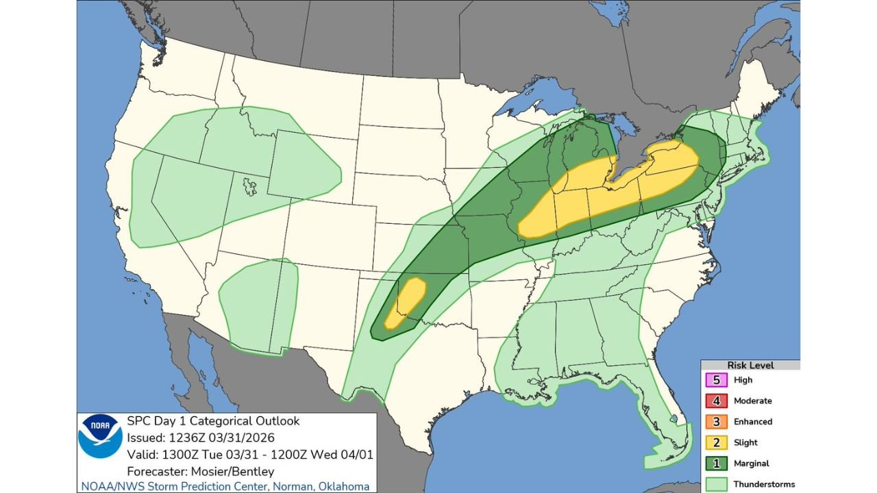
UNITED STATES — The Storm Prediction Center has issued its Day 1 Categorical Outlook for Tuesday, March 31, 2026, placing two separate and distinct severe weather zones across the central and eastern United States under a Slight Risk — Level 2 of 5. The first zone stretches from the Mid Mississippi Valley through the Ohio Valley and into the southern Great Lakes — where scattered severe thunderstorms with damaging wind gusts and large hail are the primary concerns. The second zone covers western Oklahoma and far northwest Texas — where isolated severe storms capable of large hail and damaging gusts are possible through the afternoon and evening.
This outlook was issued by the NOAA/NWS Storm Prediction Center at 1236Z on March 31, 2026, valid through 1200Z Wednesday, April 1, 2026. Forecasters Mosier and Bentley issued this outlook.
Two Zones — Two Different Threat Profiles
What makes today’s setup distinctive is the simultaneous presence of two geographically separate severe weather zones — one large and organized across the Midwest and Great Lakes, and one smaller but focused across the southern Plains. Each zone has its own atmospheric driver and its own threat profile.
Zone 1 — Mid Mississippi Valley Through the Ohio Valley and Southern Great Lakes
The larger and more significant of the two zones today stretches in a long corridor from the Mid Mississippi Valley — covering portions of Illinois, Indiana, and Missouri — eastward through the Ohio Valley and into the southern Great Lakes region covering Michigan, Ohio, Pennsylvania, and western New York.
This zone is under a Slight Risk with a broad Marginal Risk buffer surrounding it. The threat here is scattered — meaning multiple areas within the zone will see severe weather, though not every location will be impacted. Damaging wind gusts and large hail are the primary concerns across this corridor.
A strong jet stream and surface boundary providing lift across the Mid Mississippi Valley and Ohio Valley are the primary drivers of storm development in this zone today. As storms develop along and ahead of the surface boundary through the afternoon hours, they will move northeast — pushing severe weather impacts through Indiana, Ohio, Michigan, and western Pennsylvania through the afternoon and into the evening.
Zone 2 — Western Oklahoma and Far Northwest Texas
The second zone is smaller, more isolated, and centered directly over western Oklahoma and far northwest Texas — where a separate atmospheric setup is supporting isolated severe storm development independent of the larger Midwest system.
This zone is also under a Slight Risk, with storms capable of producing large hail and damaging wind gusts. The threat here is described as isolated rather than scattered — meaning fewer storms overall, but those that do develop can still produce significant severe weather impacts across a localized area.
The dryline across western Oklahoma and northwest Texas is the primary storm trigger in this zone today — a preview of the more significant dryline severe weather setup forecast for Wednesday and Friday.
SPC Day 1 Outlook — Risk Zones Today
| Zone | Area | Risk Level | Primary Threats |
|---|---|---|---|
| Zone 1 — Northern | Southern Great Lakes — Michigan, Ohio, western New York | Slight Risk | Damaging winds, large hail |
| Zone 1 — Central | Ohio Valley — Indiana, Kentucky, Pennsylvania | Slight Risk | Damaging winds, large hail |
| Zone 1 — Southern | Mid Mississippi Valley — Illinois, Missouri | Slight Risk | Damaging winds, large hail |
| Zone 2 | Western Oklahoma / Northwest Texas | Slight Risk | Large hail, damaging gusts |
| Broader surrounding area | Plains through Northeast | Marginal Risk | General thunderstorm threat |
| Pacific Northwest / Mountain West | Oregon, Colorado, Utah | Marginal Risk | Isolated thunderstorms |
What Each Threat Means Today
Damaging wind gusts — Severe thunderstorm wind gusts of 58 mph or greater are possible with the strongest storm cells across Zone 1 today. At these speeds, winds can snap tree branches, down power lines, overturn lightweight structures, and create hazardous driving conditions. Power outages are possible across portions of the Ohio Valley and Great Lakes as storms push through.
Large hail — Hail of one inch or larger is possible with organized storm cells across both zones today. In Zone 1, hail threat is highest across the Ohio Valley and southern Great Lakes where instability values are greatest. In Zone 2, discrete storm cells along the western Oklahoma dryline carry the highest hail potential of the afternoon across the southern Plains.
Isolated tornado — While not listed as a primary threat in today’s official outlook, any discrete storm that organizes in the more moist and sheared portions of Zone 1 across Indiana, Ohio, and western Pennsylvania carries a non-zero tornado potential. Residents in these areas should maintain full severe weather awareness through the afternoon and evening.
Forecast Confidence Level
High confidence on severe thunderstorm development across both zones today — the SPC Day 1 outlook with Slight Risk designation reflects high forecaster confidence on storm development and severe weather potential.
High confidence on damaging winds as the primary threat across Zone 1** — the wind shear profile and storm organization support widespread damaging wind potential across the Ohio Valley and Great Lakes corridor.
High confidence on large hail as the primary threat across Zone 2** — the dryline environment across western Oklahoma and northwest Texas is well-suited for hail-producing storm development this afternoon.
Medium confidence on exact storm coverage and timing** — Slight Risk events by definition involve scattered rather than widespread storm coverage, meaning some areas within the risk zone will see severe weather while others remain dry. Precise storm timing and track will become clearer as the afternoon develops.
What Residents in Both Zones Must Do Today
Zone 1 — Illinois, Indiana, Ohio, Michigan, Pennsylvania, Missouri, Kentucky residents:
Have your severe weather alert method active and accessible right now. Storms across Zone 1 are developing through the afternoon and will push northeast through the evening — the window for impacts spans several hours across this large corridor.
If you have outdoor plans this afternoon or evening anywhere within the Slight Risk zone, have an indoor backup option confirmed before heading out. Severe thunderstorms producing 60+ mph winds and one-inch hail can develop and move through quickly — being caught outdoors during a severe thunderstorm is dangerous.
Zone 2 — Western Oklahoma and Northwest Texas residents:
Isolated severe storms are possible through the afternoon across your region. While coverage will be limited compared to Zone 1, the storms that do develop can produce significant hail and damaging gusts. Protect vehicles and outdoor property if storms approach your area, and monitor local conditions closely through the afternoon.
Residents near the Marginal Risk boundaries — including broader portions of the Plains, Midwest, and Northeast — should remain weather aware today. The Marginal Risk designation means isolated severe storms are possible even outside the defined Slight Risk zones, particularly if a discrete storm cell organizes in a locally favorable environment.
Today Is the Beginning — Wednesday and Friday Carry Greater Risk
It is important to put today’s Slight Risk in context. Tuesday’s severe weather threat is real and deserves attention — but it is also the opening event of a multi-day severe weather pattern that escalates significantly on Wednesday, April 1 and Friday, April 3.
The same atmospheric pattern driving today’s storms — Gulf moisture building, upper-level energy moving through in sequence, and a dryline positioned across the southern Plains — intensifies considerably by Wednesday and reaches its peak expression on Friday. Residents across the central United States should treat today as a warmup for the more significant severe weather days ahead and use Tuesday’s events as a reminder to finalize shelter plans and preparation before the week’s most dangerous windows arrive.
The Bottom Line
The Storm Prediction Center has issued a Slight Risk for two separate severe weather zones today, Tuesday March 31. Zone 1 covers the Mid Mississippi Valley through the Ohio Valley and southern Great Lakes — where scattered severe thunderstorms with damaging winds and large hail are the primary threats across Illinois, Indiana, Ohio, Michigan, and Pennsylvania. Zone 2 covers western Oklahoma and northwest Texas — where isolated severe storms capable of large hail and damaging gusts are possible along the dryline this afternoon. Stay weather aware, keep alerts active, and treat today as the beginning of a multi-day severe weather pattern that escalates significantly on Wednesday and Friday.
Stay ahead of dangerous weather before it reaches your door. Visit cabarrusweekly.com for daily severe weather coverage, SPC outlook updates, and storm alerts from across the United States — because knowing early is the difference that matters.