Midwest, Plains and Great Lakes Brace for Multi-Day Severe Weather Outbreak Into Early April With Significant Storm Potential
UNITED STATES — A concerning pattern is beginning to take shape across the central and eastern United States, with consistent signals pointing toward a multi-day severe weather outbreak developing late next week and continuing into early April.
Forecast models are increasingly aligned on a large-scale trough setup, a pattern known for producing widespread storm systems, particularly across the Plains, Midwest, and Great Lakes regions.
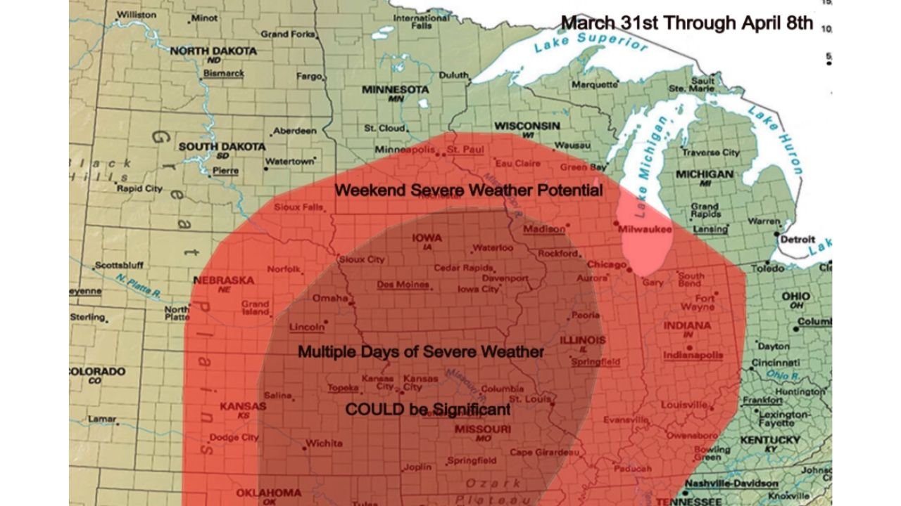
Expanding Risk Zone Covers Multiple States
Current projections highlight a broad area of concern stretching from:
- Nebraska and Kansas
- Across Iowa and Missouri
- Into Illinois, Wisconsin, and Indiana
- Extending toward parts of the Great Lakes region
This zone includes major cities such as Omaha, Kansas City, Des Moines, Chicago, Milwaukee, Indianapolis, and St. Louis, placing millions of residents within a potential severe weather corridor.
Multiple Days of Severe Storms Possible
Unlike a single-day event, this setup is notable for its extended duration, with the potential for several consecutive days of storm activity.
The most active window currently appears to be:
- Late next week (Friday through Sunday)
- Continuing into the first half of April
This raises concerns for repeated rounds of thunderstorms, which can increase the risk of both severe weather and flooding over time.
Conditions Could Support Significant Severe Weather
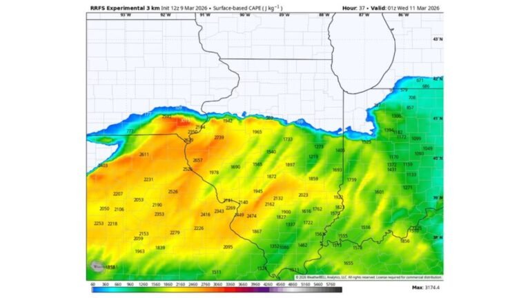
The overlapping ingredients expected in this pattern — including warm, moist air from the Gulf and strong upper-level dynamics — could create an environment supportive of more intense storms.
Based on the current outlook, threats may include:
- Widespread damaging wind events
- Large to very large hail
- Tornado potential, including stronger storms if conditions align
- Heavy rainfall leading to localized flooding
The wording in the outlook suggests that storms “could be significant,” indicating the possibility of higher-end severe weather episodes if the setup fully develops.
Why This Pattern Matters
This type of large-scale trough pattern often leads to organized storm systems tracking repeatedly over the same regions, increasing both coverage and intensity of severe weather.
It also signals a transition deeper into spring, when severe weather becomes more frequent and widespread across the central U.S.
While details such as exact timing and storm intensity will become clearer in the coming days, the early signal is strong enough to warrant attention.
Early Heads-Up as Pattern Evolves
With several days still to go, this serves as an early heads-up rather than a finalized forecast, but confidence is growing that an active and potentially dangerous stretch of weather is ahead.
Residents across the Plains, Midwest, and Great Lakes should monitor updates closely as this system evolves.
Stay with CabarrusWeekly.com for the latest updates and share conditions from your area as this developing severe weather pattern approaches.