Minnesota, Wisconsin and Michigan Bracing for Multi-Day Snowstorm as Minneapolis, Green Bay and Marquette Could See 8–16+ Inches
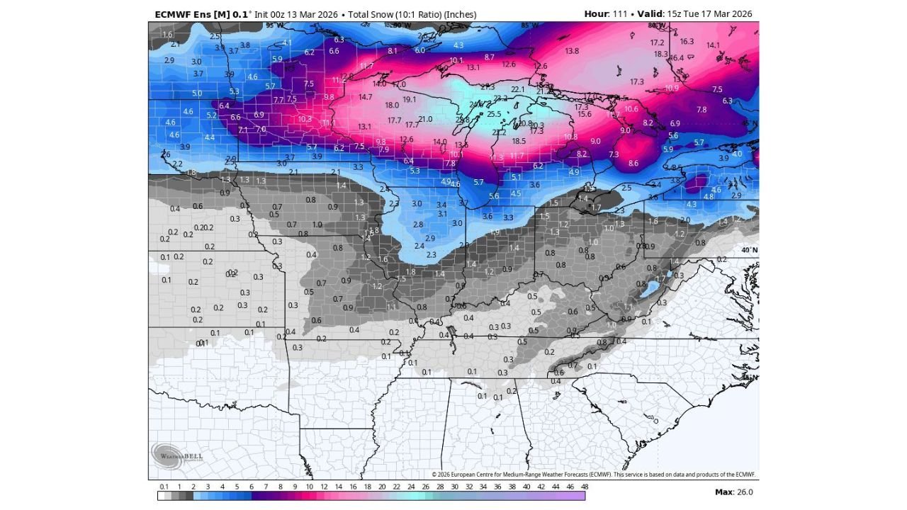
UNITED STATES — A powerful winter storm is set to dump feet of snow across parts of Minnesota, Wisconsin and northern Michigan this weekend into early next week, with forecast models highlighting a corridor of widespread 8 to 16+ inches and locally higher amounts.
The heaviest snowfall is expected to stretch from central and northern Minnesota through much of Wisconsin and into the Upper Peninsula of Michigan, creating the potential for extremely difficult travel and significant disruptions.
Heaviest Snow: Minnesota to Northern Michigan
Forecast guidance shows the most intense band of snow setting up across:
- Minneapolis and surrounding central Minnesota communities
- Duluth and northeastern Minnesota
- Much of northern and central Wisconsin, including Green Bay
- The Upper Peninsula of Michigan, including Marquette
In these areas, widespread totals of 8–16 inches appear likely, with some localized spots potentially exceeding that range if the heaviest bands persist.
Ensemble snowfall projections show several locations in northern Wisconsin and the Upper Peninsula pushing toward or above the 20-inch mark, depending on exact storm track and band placement.
Major Cities Facing Impacts
Cities that could see significant travel disruptions include:
- Minneapolis, Minnesota
- Duluth, Minnesota
- Green Bay, Wisconsin
- Marquette, Michigan
With snowfall rates potentially becoming heavy at times, road conditions could deteriorate quickly. Prolonged accumulation may overwhelm plowing efforts during peak periods of snowfall.
Snow Extends South into Iowa, Illinois and Indiana
While the most extreme totals are expected farther north, heavy snow will also extend southward into:
- Iowa
- Northern Illinois
- Northern Indiana
- Southern Michigan
In these areas, several inches of accumulation are possible, with totals generally lower than those across Minnesota and Wisconsin but still impactful enough to create hazardous road conditions.
Even moderate snowfall amounts can cause major slowdowns along busy corridors, particularly if they fall during high-traffic periods.
Timing and Duration
The system is expected to unfold this weekend and continue into early next week, increasing the risk of prolonged impacts rather than a brief burst of snow.
A long-duration event raises the potential for:
- Compounding accumulations
- Travel backlogs
- Delays in snow removal
- Secondary impacts such as school closures and flight disruptions
Airports across the Upper Midwest, particularly Minneapolis–St. Paul, could experience delays depending on snowfall intensity and wind conditions.
Why This Storm Bears Watching
The alignment of moisture and cold air across the Upper Midwest is favorable for efficient snow production. The storm track currently supports a classic heavy snow swath from Minnesota through Wisconsin into northern Michigan.
Small shifts north or south could significantly alter totals for specific cities, so exact snowfall amounts will continue to be refined in updated forecasts.
Bottom Line
Minnesota, Wisconsin and northern Michigan are in line for a significant multi-day winter storm capable of delivering 8–16+ inches of snow, with locally higher amounts possible in the hardest-hit areas.
Communities including Minneapolis, Duluth, Green Bay and Marquette should prepare for difficult travel conditions and potential disruptions as this powerful system moves through.
CabarrusWeekly.com will continue to monitor forecast updates and provide the latest timing and snowfall details as the storm approaches.