Minnesota, Wisconsin and Michigan Facing 12–24+ Inches of Snow as Wausau to Marquette Corridor Braces for Potential Blizzard Conditions
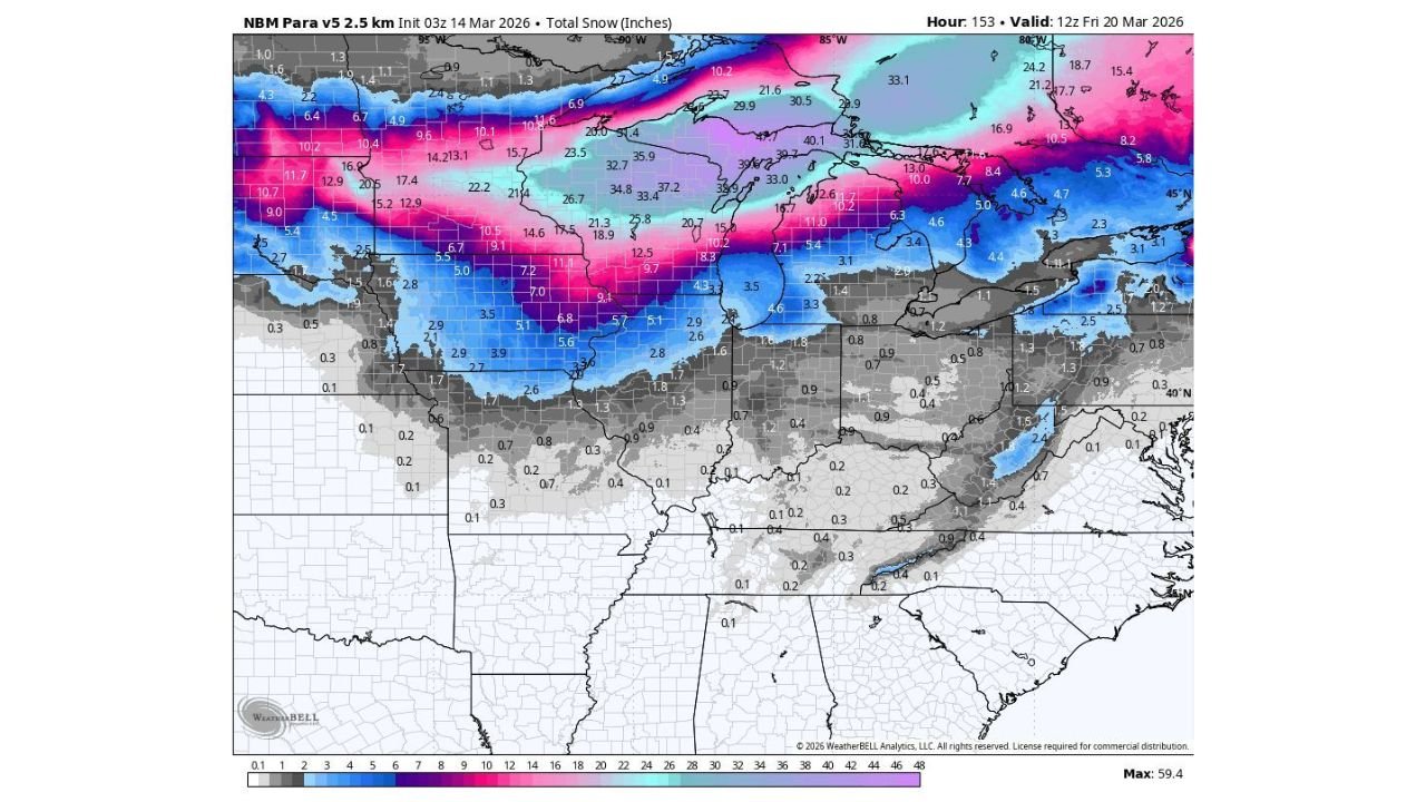
UNITED STATES — A major winter storm is poised to unload a ton of snow across Minnesota, Wisconsin and parts of Michigan beginning tomorrow, with widespread totals of 12 to 24 inches expected and localized amounts exceeding two feet from central Wisconsin into the Upper Peninsula.
Forecast guidance highlights a concentrated heavy snow band stretching from Minnesota through northern and central Wisconsin and into northern Michigan — a setup that could bring extremely difficult, if not dangerous, travel conditions.
12–24 Inches Likely Across the Upper Midwest
The heaviest snow is currently forecast across:
- Central and eastern Minnesota
- Much of Wisconsin, especially central and northern counties
- Northern Michigan and the Upper Peninsula
Localized areas over 24 inches are likely in a corridor from Wausau, Wisconsin, northeast toward Marquette, Michigan, where snowfall bands could persist the longest.
Several model projections show 20+ inch totals in this zone, with some isolated spots potentially exceeding that threshold if mesoscale banding sets up.
Major Cities in the Crosshairs
Communities that could see significant impacts include:
- Minneapolis and Duluth, Minnesota
- Wausau and Green Bay, Wisconsin
- Marquette and surrounding Upper Peninsula communities
Heavy snowfall rates may quickly overwhelm road crews, particularly during peak accumulation periods. Long-duration snowfall increases the risk of compounding travel disruptions.
Chicago Could See Snow After Severe Storms
In a sharp weather transition, some areas farther south — including Chicago — could see a few inches of snow shortly after experiencing severe thunderstorms on Sunday.
This rapid change from severe weather to accumulating snow underscores the dynamic nature of the storm system sweeping through the Midwest and Great Lakes.
While totals in northern Illinois are expected to be lower than those across Wisconsin and Michigan, even modest accumulations could create slick roads following earlier rainfall.
Snow Extends into Iowa, Illinois, Indiana and Southern Michigan
Moderate snowfall is also forecast to extend into:
- Iowa
- Northern Illinois
- Northern Indiana
- Southern Michigan
These areas may see several inches of accumulation, enough to produce hazardous travel, especially if snowfall rates intensify briefly.
Travel and Infrastructure Impacts
With 12–24+ inches expected across portions of Minnesota, Wisconsin and Michigan, impacts could include:
- Major highway slowdowns
- Airport delays and cancellations
- Potential power outages where snow becomes heavy and wet
- Reduced visibility during peak snowfall
If winds increase alongside heavy snow bands, localized near-whiteout conditions cannot be ruled out.
Bottom Line
Minnesota, Wisconsin and northern Michigan are bracing for a significant winter storm capable of delivering 12–24 inches of snow, with localized totals over two feet from Wausau to Marquette.
Residents across the Upper Midwest should prepare for dangerous travel conditions and possible disruptions as this high-impact winter system unfolds.
CabarrusWeekly.com will continue tracking snowfall projections and timing details as the storm approaches and provide updates as new forecast data becomes available.