Minnesota, Wisconsin, Michigan, Ohio, Indiana, Kentucky, Kansas, Oklahoma, Arkansas, and Northeast Face Heavy Rain, Freezing Rain, and Heavy Precipitation Hazards From April 2 Through April 6 as WPC Issues Multi-Day Hazards Outlook
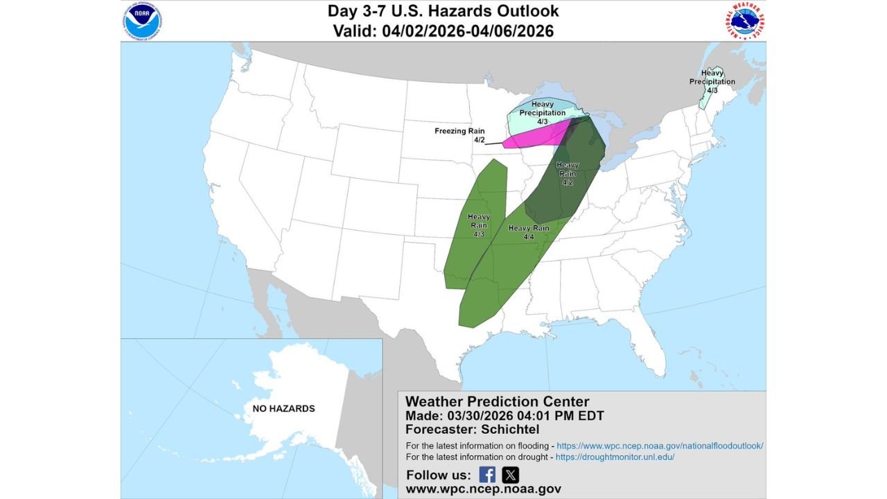
UNITED STATES — The Weather Prediction Center has issued an updated Day 3-7 Hazards Outlook covering a broad and multi-hazard weather pattern unfolding across the central and eastern United States from April 2 through April 6, 2026. Freezing rain, heavy rain, and heavy precipitation hazards are flagged across multiple separate zones — affecting states from Minnesota and Wisconsin in the north through Ohio, Indiana, and Kentucky in the Ohio Valley, down through Kansas, Oklahoma, Arkansas, and the lower Mississippi Valley, and extending into the Northeast. This is a dynamic and evolving multi-day hazard pattern that demands attention from residents across a large portion of the country heading into the first week of April.
This outlook was issued by the NOAA Weather Prediction Center on March 30, 2026 at 4:01 PM EDT.
How the Hazard Pattern Evolves Day by Day
This is not a single storm event. The WPC Day 3-7 outlook identifies multiple distinct hazard zones firing in sequence across different parts of the country on different days — reflecting the active and progressive weather pattern that has dominated the central United States all week.
Thursday, April 2 — Freezing Rain and Heavy Rain
Two separate hazards are flagged for April 2.
A freezing rain hazard is identified across a corridor covering Minnesota, Wisconsin, and the Upper Michigan Peninsula. Freezing rain is one of the most dangerous winter precipitation types — coating roads, sidewalks, power lines, and trees with a layer of ice that is nearly invisible and extremely hazardous. Even a quarter inch of ice accumulation can bring down tree branches and power lines, create treacherous travel conditions, and make walking outdoors genuinely dangerous. Residents in the freezing rain zone should prepare for potential power outages and dangerous road conditions April 2.
Simultaneously, a heavy rain hazard covers a broad corridor stretching from Ohio and Indiana through Kentucky, West Virginia, Pennsylvania, and Virginia. This is the Ohio Valley and mid-Appalachian corridor — an area that has already been dealing with above-normal precipitation through the current active pattern. Heavy rain falling on already saturated ground across this corridor raises the risk of flash flooding, river flooding, and runoff flooding through April 2.
Friday, April 3 — Heavy Precipitation and Heavy Rain Across Three Zones
April 3 is the most complex and widespread hazard day in the outlook — with three separate hazard zones active simultaneously across different regions.
A heavy precipitation hazard covers the Great Lakes region — including Michigan, Wisconsin, and Minnesota. This zone sits directly south and east of the April 2 freezing rain area, suggesting that as temperatures moderate slightly by Friday, the precipitation type transitions from freezing rain to heavy rain or mixed precipitation across the northern tier.
A heavy rain hazard covers the central Plains — including Kansas, Oklahoma, Missouri, and Arkansas. This zone aligns directly with the active severe weather corridor that has been the focus of the week’s storm pattern — and by April 3, the primary concern shifts from severe weather to the cumulative heavy rainfall that multiple storm systems will have deposited across this corridor over several consecutive days. Flooding becomes the dominant concern in this zone by Friday.
A separate heavy precipitation zone is also flagged across the Northeast — covering Maine, New Hampshire, and Vermont — as the storm system tracks northeastward and delivers heavy precipitation to New England Friday.
Saturday, April 4 — Heavy Rain Shifts Into the Lower Mississippi Valley
By April 4, the heavy rain hazard shifts southward and eastward into the lower Mississippi Valley — covering Arkansas, Louisiana, Mississippi, and Tennessee. This southward progression reflects the typical storm track evolution as the upper-level system responsible for driving the week’s active pattern pushes through and the heaviest rainfall axis shifts toward the Gulf Coast states.
Hazard Summary — April 2 Through April 6
| Date | Hazard Type | Affected Region |
|---|---|---|
| April 2 | Freezing Rain | Minnesota, Wisconsin, Upper Michigan |
| April 2 | Heavy Rain | Ohio, Indiana, Kentucky, West Virginia, Pennsylvania, Virginia |
| April 3 | Heavy Precipitation | Great Lakes — Michigan, Wisconsin, Minnesota |
| April 3 | Heavy Rain | Kansas, Oklahoma, Missouri, Arkansas |
| April 3 | Heavy Precipitation | Northeast — Maine, New Hampshire, Vermont |
| April 4 | Heavy Rain | Arkansas, Louisiana, Mississippi, Tennessee |
Why the Ohio Valley and Plains Heavy Rain Threat Is Especially Concerning
The heavy rain hazards flagged for the Ohio Valley on April 2 and the central Plains on April 3 do not exist in isolation. They are the final chapters of a multi-week wet pattern that has already delivered significant rainfall across these regions.
When heavy rain falls on ground that has already been saturated by multiple previous rainfall events over days or weeks, the soil has no remaining capacity to absorb additional water. Every inch of rain that falls goes directly into surface runoff — flowing into drainage systems, streams, and rivers that are already running high from previous events.
The Ohio River and its tributaries — which drain large portions of Ohio, Indiana, Kentucky, and West Virginia — will be responding to the accumulated rainfall from the entire week’s pattern by the time April 2’s heavy rain arrives. River flooding is a real and growing concern across the Ohio Valley heading into the first week of April.
Similarly, the Arkansas River, Missouri River, and Mississippi River tributary systems across Kansas, Oklahoma, and Arkansas will be under increasing stress from the April 3 heavy rain hazard — particularly in communities that sit in low-lying areas along these river corridors.
The Freezing Rain Threat — April 2 Across the Northern Tier
The freezing rain hazard flagged for Minnesota, Wisconsin, and Upper Michigan on April 2 deserves particular attention because it arrives at a time when many residents in these states may have mentally shifted out of winter weather mode.
Freezing rain occurs when a warm layer of air above the surface melts falling snow into rain, but the surface temperature remains at or below 32°F — causing the rain to freeze on contact with cold surfaces. The result is a coating of ice on every exposed surface that is transparent, extremely slippery, and nearly impossible to treat effectively with road salt once it accumulates.
Travel across Minnesota, Wisconsin, and Upper Michigan should be approached with extreme caution on April 2. Even light freezing rain accumulations of one tenth to one quarter inch can make roads, bridges, and overpasses dangerously slick. Heavy freezing rain accumulations can bring down power lines and cause widespread outages lasting hours to days.
Forecast Confidence Level
High confidence on the overall multi-day hazard pattern across the central and eastern United States April 2-6 — the WPC outlook is consistent with the underlying model data supporting each hazard zone.
High confidence on heavy rain across the Ohio Valley April 2** — the moisture and atmospheric lift supporting this event are well-established.
High confidence on heavy rain across the central Plains April 3** — consistent with the active severe weather pattern already forecast for Wednesday and Thursday across this corridor.
Medium confidence on freezing rain specifics April 2** — the exact rain/snow/freezing rain line across Minnesota and Wisconsin will depend on precise temperature profiles that will become clearer by Tuesday and Wednesday.
Medium confidence on April 4 heavy rain across the lower Mississippi Valley** — the southern shift of the rain axis is consistent across models but exact coverage and totals will sharpen as the date approaches.
What Residents in Each Hazard Zone Must Do
Minnesota, Wisconsin, and Upper Michigan residents facing the April 2 freezing rain hazard should prepare now for potential travel disruptions and power outages. Keep vehicles fueled, have emergency supplies accessible, and avoid non-essential travel on April 2 if freezing rain develops in your area.
Ohio, Indiana, Kentucky, West Virginia, Pennsylvania, and Virginia residents in the April 2 heavy rain zone should monitor local river and flood forecasts closely through the week. If you live in a flood-prone area or near a river or stream that has flooded before, begin taking precautions now — moving valuables out of basements and identifying your evacuation route before the rain arrives.
Kansas, Oklahoma, Missouri, and Arkansas residents in the April 3 heavy rain zone are entering the most significant cumulative rainfall period of the week. The combination of Wednesday’s severe weather rainfall and Thursday’s additional heavy rain across this corridor raises the flood risk to a level that warrants immediate and serious attention.
Arkansas, Louisiana, Mississippi, and Tennessee residents in the April 4 heavy rain zone should monitor conditions closely as the storm system tracks southward. Communities along the lower Mississippi River and its tributaries face the greatest river flooding risk as the week’s accumulated rainfall pushes downstream.
Northeast residents across Maine, New Hampshire, and Vermont should prepare for heavy precipitation April 3 — which may include a mix of rain and snow at higher elevations given the late-season timing of this system.
The Bottom Line
The NOAA Weather Prediction Center’s Day 3-7 Hazards Outlook confirms that the active and historically significant weather pattern affecting the central United States this week does not end with Wednesday’s severe weather. Freezing rain across Minnesota and Wisconsin on April 2, heavy rain across the Ohio Valley on April 2 and the central Plains on April 3, heavy precipitation across the Great Lakes and Northeast on April 3, and heavy rain across the lower Mississippi Valley on April 4 all represent real and significant hazards for millions of Americans through the first week of April. This is a multi-day, multi-hazard pattern that demands daily attention and preparation from residents across a large portion of the country.
Stay ahead of dangerous weather before it reaches your door. Visit cabarrusweekly.com for daily hazard outlooks, flood alerts, and weather updates from across the United States — because knowing early is the difference that matters.