Mississippi, Tennessee and Kentucky Bracing for Nighttime QLCS Severe Line Sunday as Damaging Winds and Embedded Tornadoes Sweep East
UNITED STATES — A fast-moving, nighttime squall line is expected to surge across Mississippi, Tennessee and Kentucky late Sunday, bringing a significant damaging wind threat along with the potential for embedded tornadoes.
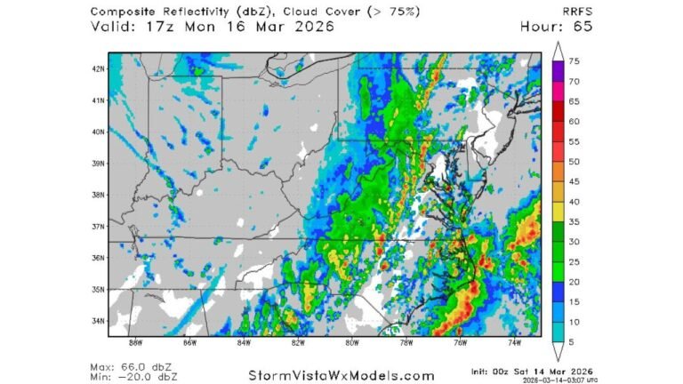
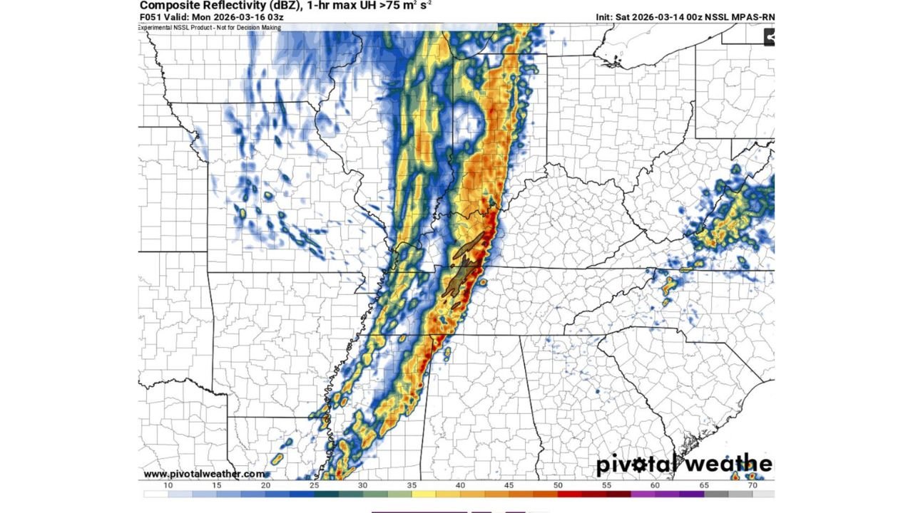
Forecast composite reflectivity guidance valid around 03z Monday (late Sunday night) shows a well-organized line of storms stretching from the lower Mississippi Valley north into the Mid-South and lower Ohio Valley. The structure suggests a classic QLCS — a quasi-linear convective system — capable of producing widespread wind damage.
A Wall of Wind and Rain After Dark
Unlike isolated supercells, this setup favors a solid line of storms — essentially a wall of heavy rain and intense wind. These systems often move quickly and can produce damaging straight-line winds over a large area.
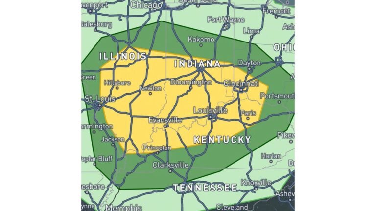
The projected line extends:
- From eastern Arkansas into western and central Mississippi
- Through western and middle Tennessee
- Northward toward western Kentucky and southern Illinois
As the system marches east, communities in Memphis, Jackson (MS), Nashville and Paducah could experience the strongest impacts during the nighttime hours.
Damaging Winds the Primary Concern
The structure of the forecast line strongly supports a significant wind event. Bowing segments within the line — visible in model output — are often associated with concentrated areas of destructive wind gusts.
Widespread tree damage and scattered power outages are possible where the strongest segments move through.
Given the linear storm mode, damaging straight-line winds appear to be the dominant hazard.
Embedded Tornado Risk
While this event is not expected to be a classic daytime tornado outbreak with discrete supercells, QLCS tornadoes remain a concern.
These tornadoes:
- Develop quickly
- Can be rain-wrapped
- Are extremely difficult to see at night
- Often provide little visual warning
The nighttime timing increases the danger, as many residents will be asleep when warnings are issued.
Timing: Late Sunday Evening Into Early Monday
The most intense portion of the line is expected late Sunday evening into the overnight hours as it advances eastward.
Because this is not a “one cell and done” event, impacts may continue until the main cold front fully clears the region early Monday.
Reduced Chase Visibility and Hazard Awareness
Meteorologists note that storm mode and timing make this event particularly challenging from a visibility standpoint. A nighttime QLCS significantly reduces the ability to visually confirm tornadoes.
For residents, that means reliance on radar, warnings and alert systems is critical.
Preparation Steps Now
With a nighttime severe event expected, preparation should happen before storms arrive:
- Ensure Wireless Emergency Alerts are enabled
- Keep phones fully charged
- Have multiple ways to receive warnings
- Identify a safe shelter location inside your home
- Avoid relying solely on outdoor sirens
Nighttime severe weather events historically pose a higher risk because warnings may go unnoticed.
Bottom Line
Mississippi, Tennessee and Kentucky are facing a potentially impactful nighttime severe weather event Sunday. A fast-moving QLCS line is expected to bring widespread damaging winds and the possibility of embedded tornadoes.
This is shaping up to be a radar-driven event with limited visibility and rapid storm motion. Residents across the Mid-South and lower Ohio Valley should finalize preparations now and remain weather-aware through the overnight hours.
CabarrusWeekly.com will continue to monitor updates as this severe line organizes and moves east.