Missouri, Illinois, Arkansas, Iowa, Indiana, Kentucky, and Ohio Face Higher-End Severe Weather Threat Friday April 3 as NSSL Machine Learning Model Shows Strongest Signal of the Week With All Severe Modes Possible
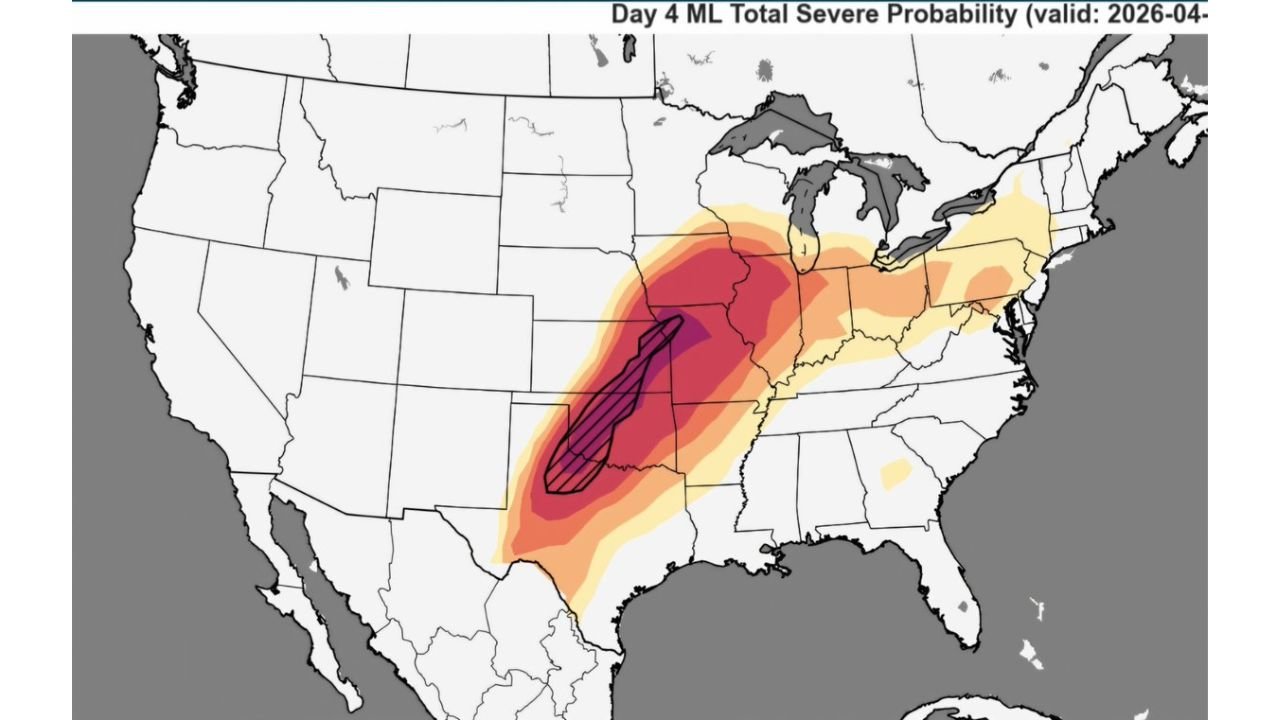
UNITED STATES — The most significant severe weather signal of the entire week arrives on Friday, April 3, 2026. The NSSL Machine Learning Severe Weather Model is showing its strongest and most concentrated severe probability output of the spring active pattern for Friday — a deep purple to black core centered over the Missouri, Illinois, and Arkansas corridor with prominent hatching indicating significant severe weather potential. All severe modes — tornadoes, large hail, and damaging winds — are possible across a wide swath of the central United States, and the ML model’s Friday signal is notably stronger than Wednesday’s already serious setup.
Friday’s Signal Is Stronger Than Wednesday
Comparing the two ML model outputs side by side tells an important story. Wednesday carries a serious severe weather threat across the Plains — but Friday’s output shows a more intense, more concentrated, and more prominent hatched zone centered further north and east over Missouri, Illinois, and Arkansas.
The deep purple and black core probability on Friday is larger and more defined than Wednesday’s equivalent zone — and the hatching, which indicates the model’s highest confidence in significant severe weather outcomes, extends further and covers a more populated corridor on Friday than it does on Wednesday.
This is not a minor follow-up event to Wednesday. The ML model is treating Friday as the higher-end severe weather day of the two — and the atmospheric reasoning behind that signal is sound. By Friday, the upper-level closed low that has been deepening all week is fully organized and positioned directly over the central Plains, providing maximum dynamic support for severe storm development across the Midwest and Ohio Valley.
Where Friday’s Threat Is Concentrated
The ML model’s Friday output shows a clear and well-defined geographic focus for the highest severe weather probability.
The deep purple to black core — representing the highest probability of significant severe weather — is centered over a corridor running from northern Arkansas through Missouri and into southern Illinois. This is the zone where tornado, hail, and wind threats converge at their highest intensity Friday.
Surrounding that core, a broad dark red to red probability zone extends northward through Iowa and eastward through Indiana, Kentucky, and Ohio — placing major cities including St. Louis, Kansas City, Indianapolis, Louisville, Cincinnati, and Columbus within an elevated severe weather probability zone for Friday.
The threat extends further north into Michigan and Wisconsin at lower probability levels, and southward through Arkansas and into portions of Mississippi and Tennessee on the southern fringe of the system.
Severe Probability by Region — Friday April 3
| Region | ML Severe Probability Signal |
|---|---|
| Missouri / Southern Illinois / Northern Arkansas | Extreme — deep purple/black core with hatching |
| Iowa / Northern Missouri | Very high — dark red |
| Indiana / Kentucky | High — red to dark red |
| Ohio / West Virginia | High — red to orange |
| Michigan / Wisconsin | Moderate — orange |
| Tennessee / Mississippi | Moderate — orange fringe |
| Texas / Oklahoma | Moderate — orange to yellow |
| Pennsylvania / Mid-Atlantic | Low to moderate — yellow fringe |
Why Friday May Be More Dangerous Than Wednesday
Several atmospheric factors combine to make Friday’s setup potentially more dangerous than Wednesday’s — despite Wednesday already being a significant severe weather day.
The upper-level system is more mature on Friday. By April 3, the closed low pressure system that drives Friday’s severe weather has had two additional days to deepen and organize compared to Wednesday’s trough. A more mature and organized upper-level system provides stronger and more sustained lift for storm development — meaning storms on Friday are likely to be more intense and longer-lived than their Wednesday counterparts.
The moisture has had more time to surge northward. Gulf moisture that begins building Wednesday and Thursday will be even deeper and more widespread by Friday afternoon — giving storm updrafts a richer fuel source to work with across the Midwest and Ohio Valley corridor.
The risk corridor shifts into a more populated zone. Wednesday’s highest threat is centered over the relatively rural Kansas-Oklahoma border area. Friday’s highest threat is centered over Missouri, Illinois, and Arkansas — a corridor that includes St. Louis, Springfield, Little Rock, and other population centers — meaning more people are directly in the path of the most intense severe weather zone.
All severe modes remain fully in play. Just like Wednesday, Friday supports the full spectrum of severe weather — tornadoes, very large hail, and damaging straight-line winds — across the entire risk corridor. The hatching over the Missouri-Illinois-Arkansas core zone specifically indicates that significant tornadoes are considered a realistic outcome for Friday.
Forecast Confidence Level
High confidence on a significant severe weather event Friday across Missouri, Illinois, Arkansas, Iowa, Indiana, and Kentucky — multiple models and the ML output are consistent on a higher-end severe weather day.
High confidence on the Missouri-Illinois-Arkansas corridor as the highest-risk zone** — the ML model’s deep core probability and prominent hatching over this area is consistent across recent model runs.
Medium confidence on exact storm coverage and tornado tracks** — Friday is still several days away and the exact storm initiation timing, mode, and track will become much clearer by Wednesday and Thursday as forecast confidence increases.
High confidence on this being the stronger of the two severe weather days this week** — the ML model signal for Friday is more intense than Wednesday’s output by a meaningful margin.
What Residents Must Do Now — Before Friday Arrives
Do not let Wednesday’s severe weather event create complacency about Friday. These are two separate and distinct severe weather events — surviving Wednesday without significant impacts does not mean Friday is less dangerous. Each event must be treated on its own terms.
Missouri, Illinois, and Arkansas residents face the highest Friday severe weather risk of any state in the country. Begin finalizing shelter plans now — before the week’s active weather pattern consumes attention elsewhere. Know your safe room, know your alert methods, and have your severe weather kit assembled before Friday morning.
Iowa, Indiana, Kentucky, and Ohio residents — the ML model’s red to dark red signal across your states on Friday is not background noise. This is a genuine and significant severe weather threat that warrants full preparation. Monitor updated SPC outlooks Wednesday and Thursday as confidence increases.
St. Louis, Kansas City, Indianapolis, Louisville, Cincinnati, and Columbus residents — major metropolitan areas sitting within the elevated probability zone Friday need the same level of preparation as rural communities. Urban severe weather events are particularly dangerous due to population density and the potential for widespread power outages affecting critical infrastructure.
Plan for potential power outages lasting hours to days after Friday’s event. Severe thunderstorm wind events associated with organized storm systems can cause widespread tree damage and power line failures across large areas. Have backup power, water, and food supplies ready before Friday arrives.
The Bottom Line
The NSSL Machine Learning Severe Weather Model is showing its strongest and most concentrated signal of the week for Friday, April 3 — a higher-end severe weather setup centered over Missouri, Illinois, and Arkansas with elevated threat extending through Iowa, Indiana, Kentucky, and Ohio. The deep purple core with prominent hatching signals that significant severe weather including strong tornadoes, very large hail, and damaging winds is a realistic outcome across the highest-risk corridor Friday. This is the more dangerous of the two major severe weather days this week — and it demands the same level of serious preparation as any significant severe weather event. Do not wait until Friday to get ready. Start now.
Stay ahead of dangerous weather before it reaches your door. Visit cabarrusweekly.com for daily severe weather coverage, tornado outlooks, and storm alerts from across the United States — because knowing early is the difference that matters.