Missouri, Illinois, Indiana and Ohio in Focus as March 26 Severe Storm Setup Builds with Wind Shear and Rising Moisture
MISSOURI TO OHIO — A developing weather setup is drawing increasing attention as forecasters monitor the potential for severe storms to erupt on Thursday, March 26, stretching from the Midwest into the Ohio Valley.
While the event is still several days away, early signals suggest that the ingredients for severe weather may come together across parts of Missouri, Illinois, Indiana, and Ohio, raising concerns for strong storms by late week.
Ingredients Beginning to Align Across the Midwest and Ohio Valley
Forecast models indicate a corridor of concern forming from northeast Missouri through central Illinois, Indiana, and into Ohio, where atmospheric conditions could support storm development.
Key factors expected to be in place include:
- Increasing moisture, with dew points climbing into the 60s
- Strong wind shear, which helps storms organize and intensify
- A developing system capable of triggering storm initiation
This combination is often associated with organized thunderstorms, including the potential for severe weather.
Why This Setup Matters
The presence of both moisture and wind shear is critical. When these elements overlap:
- Storms can become longer-lived and more intense
- There is a higher chance for damaging winds and large hail
- In some cases, the setup can support rotating storms
Although it is still early, the overall pattern suggests that the region should remain alert as Thursday approaches.
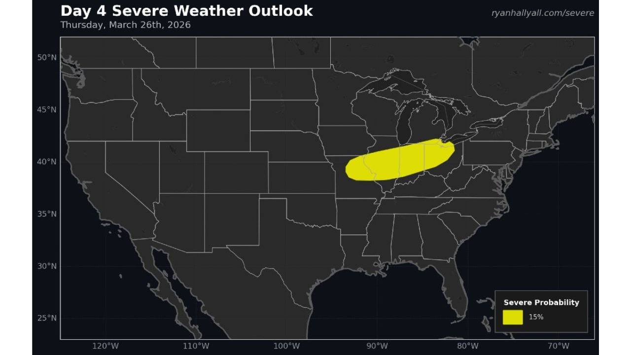
Early Outlook Highlights 15 Percent Severe Risk Zone
Current projections outline a broad 15% severe weather probability area, covering:
- Northeastern Missouri
- Much of Illinois
- Central and northern Indiana
- Large portions of Ohio
This level of risk indicates that scattered severe storms are possible within the region, though not everyone will experience severe conditions.
Timing and Uncertainty Still Key Factors
Forecasters emphasize that this is a Day 4 outlook, meaning:
- Exact storm timing is still uncertain
- Specific cities or counties most at risk cannot yet be pinpointed
- The setup could still shift north or south over the coming days
Small changes in the track of the system or placement of boundaries could significantly impact where storms develop.
What Could Happen if Storms Develop
If storms do form along this corridor Thursday afternoon or evening, the main threats could include:
- Large hail, potentially damaging vehicles and property
- Strong wind gusts, capable of downing trees or power lines
- Locally heavy rain in stronger storm cells
At this stage, tornado risk is not clearly defined but cannot be completely ruled out depending on how the setup evolves.
A Pattern Worth Watching Closely
This developing setup comes as the broader weather pattern across the U.S. becomes more active heading into late March and early April.
With warm, moist air returning northward and stronger systems moving across the country, the frequency of severe weather events is expected to increase.
Final Outlook
While it is too early for precise forecasts, confidence is growing that Missouri, Illinois, Indiana, and Ohio could see a round of severe storms on March 26 if current trends continue.
Residents across these states should stay updated in the coming days as forecast details become clearer and potential impacts are refined.
Stay tuned to CabarrusWeekly.com for the latest severe weather updates as this situation develops.