Montana, Minnesota, Wisconsin, Texas, Louisiana, Mississippi, Alabama, Georgia, and Southeast Face Above Normal Precipitation From April 10 Through April 23 While West Coast and Central Plains Trend Drier Than Normal
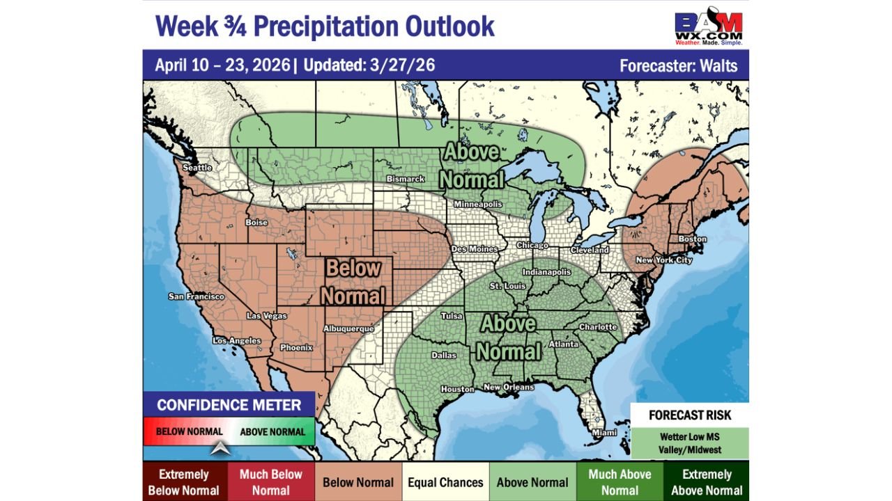
UNITED STATES — Extended range forecasts for the April 10–23, 2026 period are painting a clear picture of a divided nation — wet conditions across the northern tier and southern United States while the West Coast and central Plains trend significantly drier than normal. The main question forecasters are wrestling with is not whether this pattern sets up, but exactly when the current active weather pattern transitions into this longer-range configuration.
The Big Picture — Dry West, Wet North and South
Two distinct wet zones are emerging in the April 10–23 forecast, separated by a broad dry corridor running through the central and western United States.
The northern tier — from Montana and the Dakotas through Minnesota, Wisconsin, and Michigan — is forecast to see above normal precipitation during this period. This is consistent with an active storm track remaining across the northern United States through mid-April.
The southern tier — from Tulsa and Dallas through Houston, New Orleans, Atlanta, Charlotte, and Miami — is also forecast to see above normal precipitation. Gulf moisture continuing to stream northward will keep the Deep South and Southeast in a wetter than normal pattern through the third and fourth weeks of April.
Sandwiched between these two wet zones is a broad below normal zone covering the West Coast, the Intermountain West, and the central Plains — a dry corridor stretching from Seattle and San Francisco through Las Vegas, Los Angeles, Phoenix, Albuquerque, and into the heart of the Plains.
Precipitation Outlook by Region — April 10–23
| Region | Precipitation Outlook |
|---|---|
| Montana / Dakotas / Minnesota | Above Normal |
| Wisconsin / Michigan | Above Normal |
| Texas / Oklahoma / Louisiana | Above Normal |
| Mississippi / Alabama / Georgia | Above Normal |
| Charlotte / Atlanta / Miami | Above Normal |
| Iowa / Illinois / Indiana / Missouri | Equal Chances |
| New York / Boston / Mid-Atlantic | Equal Chances to Above Normal |
| Seattle / Boise / San Francisco | Below Normal |
| Las Vegas / Los Angeles / Phoenix | Below Normal |
| Albuquerque / Denver | Below Normal |
| Central Plains (Kansas / Nebraska) | Below Normal |
The Forecast Risk — Wetter Mississippi Valley and Midwest
The forecast risk noted for this period points toward a wetter outcome across the lower Mississippi Valley and Midwest — meaning if the forecast busts in either direction, it is more likely to bust wetter rather than drier across that corridor. Areas like St. Louis, Memphis, Indianapolis, and Chicago sit near the boundary between equal chances and above normal — and the risk skews toward those areas seeing more rain than the base forecast suggests.
This is particularly significant given the heavy rainfall already forecast for the Mississippi Valley and Ohio Valley during the current active weather pattern through early April. If the April 10–23 period also trends wetter than normal across the same corridor, cumulative rainfall totals and river flooding become an increasingly serious concern heading into the second half of April.
Forecast Confidence Level
Medium confidence overall on the April 10–23 outlook — extended range forecasts at this time range carry inherent uncertainty, and the exact timing of the pattern transition from the current active setup to this configuration remains the primary unknown.
Higher confidence on below normal precipitation across the West — the dry signal for the West Coast and Intermountain West is consistent and well-supported across multiple model runs.
Medium confidence on above normal precipitation across the southern tier — Gulf moisture availability supports the wetter signal, but storm track positioning will determine exactly which areas see the most rainfall.
What This Means for Residents
Western states from Seattle through Los Angeles, Las Vegas, and Phoenix are forecast to see a drier than normal stretch from April 10–23. After the active early April pattern, this represents a significant dry-down period for the West — which has implications for wildfire fuel moisture heading into late spring.
Residents across Texas, Louisiana, Mississippi, Alabama, and Georgia should prepare for a continued wet pattern through the third and fourth weeks of April. If you are in a flood-prone area and already dealing with elevated river levels from early April rainfall, the above normal precipitation signal for mid-April means conditions may not improve as quickly as hoped.
Northern tier residents across Minnesota, Wisconsin, and Michigan can expect above normal precipitation — which at this time of year could mean rain, late-season snow, or a mix depending on temperatures during individual storm systems.
Central and eastern US residents near the equal chances zone should monitor updated forecasts as April 10 approaches — the forecast risk skewing wetter means this area could shift into the above normal category as the period draws closer.
The Bottom Line
The April 10–23 precipitation outlook shows a divided nation — above normal rainfall across the northern tier and southern United States while the West and central Plains trend drier than normal. The forecast risk for this period skews toward a wetter outcome across the lower Mississippi Valley and Midwest, adding to what is already expected to be a very wet early April across that corridor. Monitor updated extended range forecasts as the period approaches — the exact pattern transition timing will become clearer by early next week.
Stay ahead of changing weather patterns before they arrive. Visit cabarrusweekly.com for daily extended range outlooks, flood alerts, and precipitation forecasts from across the United States — because knowing early is the difference that matters.