Multi-Day Pacific Storm Pattern Signals Extreme Snowfall in California’s Sierra Nevada and Heavy Rain Across Southern California
CALIFORNIA — A powerful and slow-moving Pacific storm pattern is signaling a prolonged period of heavy precipitation across California, with the most extreme impacts expected in the Sierra Nevada and significant rainfall extending into Southern California through the middle of February.
Cold Upper-Level Lows Drive Extended Precipitation Window
Forecast guidance shows cold upper-level low pressure systems slowing as they move inland, allowing moisture to continuously feed into California from the Pacific. This setup significantly increases the risk of multi-day precipitation, rather than a quick-moving storm.
The highest confidence window for sustained impacts currently spans February 14 through February 20, when repeated rounds of precipitation are projected.
Extreme Snowfall Potential in the Sierra Nevada
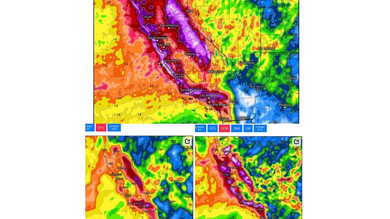
Model precipitation output highlights exceptionally high liquid-equivalent totals across the Sierra Nevada, which would translate to very large snowfall accumulations at higher elevations. The persistence of cold air combined with continuous moisture flow supports the potential for multiple feet of snow, especially along the central and northern Sierra crest.
This type of prolonged snowfall pattern raises concerns for travel disruptions, avalanche risk, and infrastructure strain in mountain communities.
Heavy Rain Signal Expands Into Southern California
Farther south, precipitation projections show widespread heavy rain across coastal and inland Southern California, including areas near Los Angeles, Santa Barbara, and San Diego County. While snow levels remain elevated in these regions, the rain signal is strong enough to raise concerns for urban flooding, runoff issues, and debris flows, particularly near burn scar locations.
Rainfall intensity increases where terrain enhances lift along coastal ranges.
Broader Western Impacts Remain Possible
While California remains the primary focus, moisture and precipitation extend eastward into parts of Nevada and the Desert Southwest, though totals decrease significantly away from the coast and higher terrain. The overall pattern favors California as the primary recipient of prolonged impacts.
Forecast Confidence Increasing but Details Still Evolving
Confidence is growing in the existence of a high-impact precipitation event, though exact snowfall totals and rain amounts will continue to refine as the event approaches. The slow-moving nature of the pattern means small shifts in storm track or temperature could meaningfully alter local outcomes.
CabarrusWeekly.com will continue monitoring this developing Western U.S. storm pattern and provide updates as confidence increases and impacts become clearer. Readers with ties to California or the Sierra Nevada are encouraged to share observed conditions and impacts with the Cabarrus Weekly Weather Desk.