Multi-Day Severe Storm Threat Expands From Texas and Oklahoma Into Missouri, Illinois, Indiana and the Mid-Mississippi Valley — Friday Emerging as the Most Dangerous Day
UNITED STATES — Storm season is beginning to wake up across the middle of the country, with multiple days of severe weather potential unfolding from Texas and Oklahoma northeast into Missouri, Illinois, Indiana and parts of the Ohio Valley.
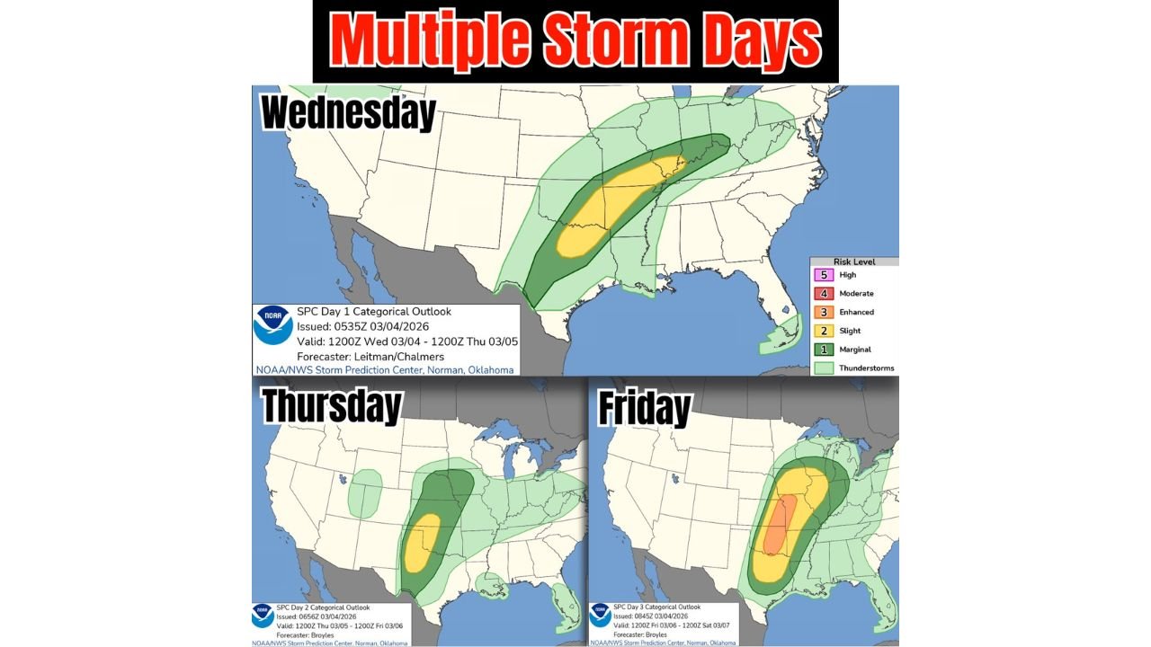
Latest Storm Prediction Center (SPC) outlooks show a three-day stretch of thunderstorm activity, with Friday currently carrying the strongest signal for organized severe storms.
Wednesday: Storm Corridor From Texas to the Ohio Valley
For Wednesday, the SPC Day 1 outlook highlights a broad zone of thunderstorms stretching from:
- Central and eastern Texas
- Oklahoma
- Arkansas
- Missouri
- Into parts of Illinois, Indiana and Kentucky
A Slight Risk (Level 2 of 5) area is positioned from north Texas and Oklahoma into portions of Arkansas and Missouri, surrounded by a broader Marginal Risk area extending into the lower Midwest and parts of the Southeast.
This setup suggests scattered severe storms capable of:
- Large hail
- Damaging wind gusts
- Isolated tornado potential
Storm coverage appears most focused from north Texas into eastern Oklahoma and western Arkansas, extending northeastward.
Thursday: Risk Shifts East Across the Plains and Midwest
By Thursday, the severe weather threat shifts slightly east and north.
The Day 2 outlook shows:
- A concentrated corridor from central Texas and Oklahoma
- Into Kansas
- Stretching toward Missouri and Iowa
The primary Slight Risk area remains centered over the southern Plains into the lower Midwest, indicating continued potential for organized thunderstorms.
While Thursday may not be as widespread as Friday, the setup supports:
- Strong wind fields
- Increasing moisture return
- Storm clustering along frontal boundaries
Residents across Oklahoma, Kansas, Missouri and surrounding states should monitor updates as details refine.
Friday: Strongest Signal Emerging Across the Mississippi Valley
Friday’s Day 3 outlook shows the most concerning configuration of the week.
A more focused severe corridor extends from:
- Arkansas
- Missouri
- Illinois
- Indiana
- Possibly into parts of western Kentucky and Tennessee
An Enhanced Risk (Level 3 of 5) appears embedded within the broader risk zone, signaling a greater likelihood of severe storm development.
This type of setup typically favors:
- Widespread damaging winds
- Large hail
- A more organized tornado threat
The alignment of the risk zone suggests storms tracking northeast through the Mid-Mississippi Valley into the lower Ohio Valley.
What This Means for the Central U.S.
This multi-day pattern indicates:
- Repeated storm chances across the Plains and Midwest
- Increasing atmospheric energy through the week
- A more consolidated severe setup by Friday
While exact storm placement will depend on mesoscale details that become clearer closer to each event, forecast confidence is increasing that at least some communities from Texas to Illinois and Indiana will see strong to severe thunderstorms before the week ends.
Staying Weather Aware
With spring systems beginning to organize, this stretch marks one of the more active severe weather periods so far this year for the middle United States.
Anyone with travel or outdoor plans Wednesday through Friday across:
- Texas
- Oklahoma
- Kansas
- Missouri
- Illinois
- Indiana
- Arkansas
should stay alert for forecast updates, watches, and possible warnings as the situation evolves.
CabarrusWeekly.com will continue monitoring this developing multi-day severe weather setup and provide additional updates as confidence increases and timing becomes clearer.