Multi-Day Severe Weather Outbreak Targets Texas, Oklahoma and Midwest Through Friday with 2+ Inch Hail and Tornado Risk
UNITED STATES — An active and potentially dangerous severe weather pattern is expected to unfold from Wednesday, March 4 through Friday, March 6, stretching from the southern Plains into parts of the Midwest.
Forecasters highlight large hail, damaging wind gusts and tornadoes as possible hazards, with very large hail (2 inches or greater) specifically noted for Thursday and Friday.
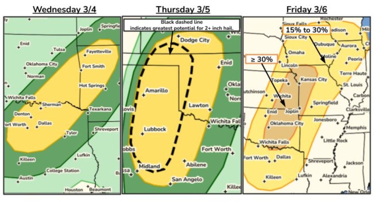
Wednesday, March 4: Southern Plains Under Threat
Severe thunderstorms are expected to develop Wednesday across parts of:
- North Texas
- Southern and eastern Oklahoma
- Western Arkansas
Cities such as Dallas, Fort Worth, Wichita Falls, Oklahoma City, Tulsa, and Fort Smith fall within the highlighted zone.
Storms Wednesday may produce:
- Large hail
- Strong wind gusts
- A tornado risk
This marks the beginning of a multi-day severe weather setup.
Thursday, March 5: Highest Hail Risk in West Texas and Western Oklahoma
Thursday’s outlook shows a more focused corridor from:
- Midland and Lubbock
- Northward through Amarillo
- Into areas near Lawton and Dodge City
A black dashed zone indicates the greatest potential for very large hail exceeding 2 inches in diameter.
This corridor covers parts of:
- West Texas
- Texas Panhandle
- Western Oklahoma
- Southwest Kansas
All severe hazards remain possible Thursday, but hail appears to be the primary concern based on the highlighted zone.
Friday, March 6: Risk Expands Into the Midwest
By Friday, the severe weather threat shifts and expands northeast into:
- Oklahoma
- Kansas
- Missouri
- Iowa
- Illinois
The map highlights probabilities in the 15% to 30% range, with some areas showing 30% or greater severe risk within 25 miles of a point.
Cities that may be impacted include:
- Oklahoma City
- Wichita
- Kansas City
- Springfield
- Peoria
- St. Louis
- Lincoln
- Omaha
This suggests organized severe storms could continue into the Mid-Mississippi Valley and portions of the central Midwest.
All Hazards Possible Through the Period
Across the three-day period, the primary risks include:
- Large to very large hail (2+ inches possible Thursday and Friday)
- Damaging wind gusts
- Tornado potential
The evolving pattern indicates strengthening storm systems tracking from the southern Plains toward the Midwest, a common early-March transition into spring severe season.
Why Cabarrus County Should Monitor the Pattern
Although the immediate threat is centered well west of North Carolina, multi-day Plains severe setups often signal a broader pattern shift.
Storm systems that organize over Texas and Oklahoma frequently progress eastward in subsequent days, sometimes influencing the Tennessee Valley and Southeast.
CabarrusWeekly.com will continue tracking developments as this active severe weather stretch unfolds and assess any downstream impacts that could affect the Carolinas later this week.