Multiple Pacific Systems Line Up This Week as Stronger Weekend Storm Threat Emerges Behind Midweek Wave
PACIFIC COAST — A busy and evolving weather pattern is unfolding across the eastern Pacific, with multiple systems lined up to impact the West Coast this week, including a weaker midweek disturbance and a potentially stronger storm heading into the weekend.
Midweek System Targets California First
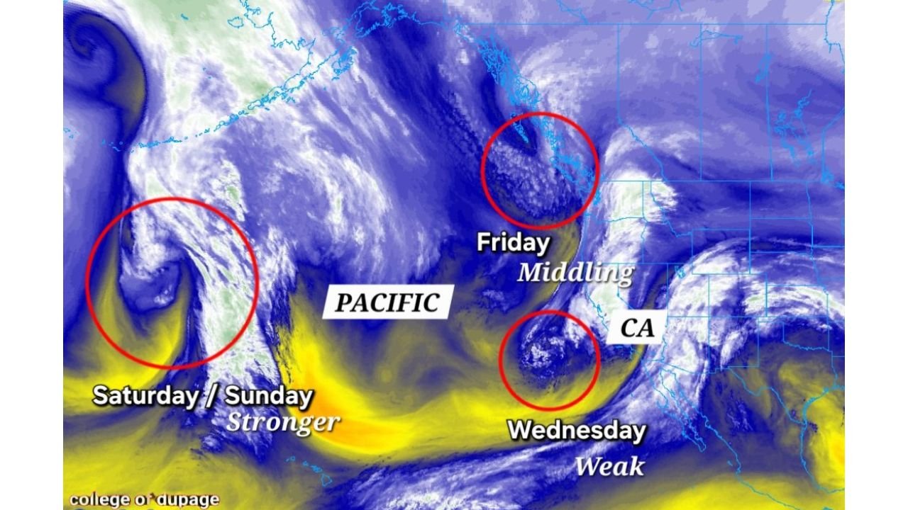
The first system in this sequence is labeled as a “Wednesday – Weak” feature, positioned just offshore of California. Satellite imagery highlights a compact disturbance moving toward the state, likely bringing areas of rain and mountain snow as it pushes inland.
While categorized as weaker compared to what follows, this midweek system could still produce localized travel impacts in higher elevations, especially where colder air supports accumulating snow. Lower elevations are more likely to see periods of rain with limited wintry issues.
Friday System Adds Another Round of Unsettled Weather
Behind Wednesday’s wave, another disturbance labeled “Friday – Middling” develops offshore. This system appears more organized than the midweek feature and may deliver a broader shield of precipitation along parts of the West Coast.
Moisture streaming in from the Pacific suggests moderate rainfall potential along coastal sections, with snow likely in the Sierra Nevada and other higher terrain. The exact intensity will depend on how quickly the system consolidates as it approaches land.
This setup signals a transition into a more active regime, where storms arrive in closer succession.
Stronger Weekend Storm Looms Offshore
The most eye-catching feature on the map is a large, well-defined circulation over the Pacific labeled “Saturday / Sunday – Stronger.” This trailing system appears deeper and more robust, suggesting the potential for stronger winds, heavier precipitation, and more widespread impacts.
If current trends hold, this weekend storm could bring:
- Heavier coastal rain
- Significant mountain snowfall
- Stronger wind gusts
- Potential for more complex precipitation types inland depending on temperature profiles
The trailing nature of this system also hints that it could qualify as a more notable late-February storm event, especially if cold air becomes involved in interior regions.
Pattern Shift Brings Multiple Impacts
The presence of several systems in quick succession suggests a broader pattern shift across the eastern Pacific. Instead of a single storm, this regime favors repeated waves of moisture and energy moving inland, increasing cumulative precipitation totals.
With each incoming system, there is also the potential for mixed or icy corridors in interior locations, particularly where colder air lingers between waves. The interplay between incoming Pacific moisture and inland temperature profiles will determine how disruptive conditions become.
What to Watch in the Days Ahead
Key forecast elements to monitor include:
- The strength and track of the weekend system
- Snow levels in mountain regions
- Wind potential along coastal areas
- Any inland zones where rain could mix with snow or ice
While not every wave will produce high-end impacts, the overall setup supports an active stretch of late-February weather along the West Coast.
We will continue tracking how these systems evolve through the week. If you’re experiencing changing conditions in your area, share your observations with us at CabarrusWeekly.com and stay tuned for the latest weather updates.