Multiple Severe Weather Rounds Target North Texas, Oklahoma, Kansas and Missouri This Week as Tornado Risk Peaks Friday Across the Southern Plains
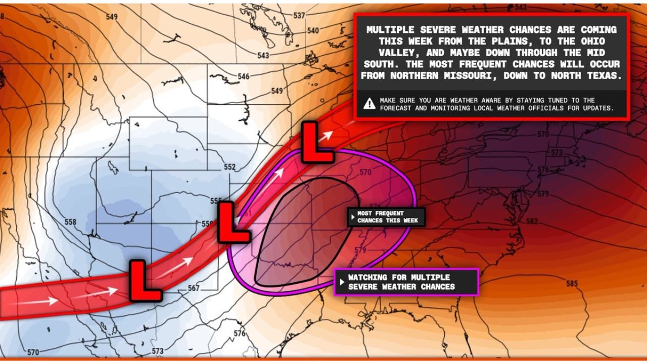
SOUTHERN PLAINS — A highly active early-March pattern is setting up across the central United States, with multiple rounds of severe weather expected from North Texas through Oklahoma, eastern Kansas and into Missouri over the coming days.
Forecast guidance indicates Wednesday, March 4, and Friday, March 6 as key days to watch, with Friday currently showing the strongest potential for organized severe storms — including an isolated tornado threat.
Severe Weather Corridor from Texas to Missouri
Model projections highlight a consistent storm track stretching from:
- North Texas
- Central and eastern Oklahoma
- Eastern Kansas
- Missouri
- Extending northeast toward portions of the Ohio Valley
The most frequent severe weather chances appear centered from northern Missouri southward into North Texas, where repeated disturbances are forecast to move along the same corridor.
This setup supports multiple rounds of thunderstorms rather than a single event.
Friday Showing Higher-End Potential
While Wednesday brings an initial severe weather risk, Friday stands out as the day with greater upper-level support and improved low-level wind dynamics.
Key atmospheric ingredients expected to align include:
- A pronounced dry line across the southern Plains
- A strengthening low-level jet
- Rich Gulf moisture with dew points rising into the 60s
- Colder air aloft increasing instability
This combination increases the risk for supercell development, capable of producing:
- Large hail
- Damaging wind gusts
- An isolated tornado threat, especially across North Texas and southern Oklahoma
Eastern Kansas and western Missouri may also see strong storms as activity shifts northeast.
Ohio Valley and Mid-South Also in Play
Beyond the Plains, the broader pattern supports severe weather potential extending into parts of:
- Arkansas
- Western Tennessee
- Kentucky
- Portions of the Ohio Valley
While the highest-end tornado parameters currently favor the southern Plains on Friday, additional rounds later in the week could impact these downstream areas.
Why This Early-Season Setup Is Notable
Early March events often lack sufficient moisture, but this system features dew points in the 60s, which is significant for this time of year.
Combined with strong upper-level energy and multiple surface lows tracking across the region, the environment appears supportive of organized severe convection.
The repeated nature of these disturbances increases the chance for:
- Storm clustering
- Training thunderstorms
- Elevated flash flooding in localized areas
What Residents Should Do
Communities across Texas, Oklahoma, Kansas and Missouri should closely monitor forecast updates through midweek as finer details on storm timing and exact target zones become clearer.
Residents are encouraged to:
- Review severe weather safety plans
- Ensure multiple ways to receive warnings
- Stay alert for forecast updates, especially heading into Friday
The pattern suggests this will not be a one-day event but rather multiple opportunities for severe storms across the Plains and into the Midwest.
CabarrusWeekly.com will continue tracking developments and provide updates as the storm track and highest-risk areas become more defined.