Multiple Tornado Warnings Ongoing Across Louisiana and Mississippi as Dangerous Squall Line Races Toward New Orleans
LOUISIANA AND MISSISSIPPI — Multiple tornado warnings remain in effect late tonight as a powerful squall line pushes eastward across southern Louisiana into southern Mississippi, bringing dangerous winds and active rotation.
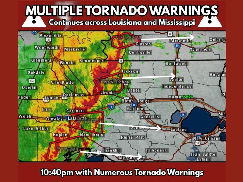
Radar imagery shows a well-defined line of severe storms stretching from central Louisiana southward to the Gulf Coast. As of approximately 10:40 PM, numerous tornado warnings were ongoing along and ahead of the line as it advances toward heavily populated areas.
Tornado Warnings From Central Louisiana to the Gulf Coast
The most intense portion of the squall line is currently impacting communities including Alexandria, Woodworth, Marksville, Bunkie, and Simmesport, where heavy rainfall and embedded rotation have been detected.
Farther south, tornado warnings have been issued near Jackson, Livonia, New Roads, and Lafayette, with strong storm cores moving rapidly eastward. Additional warnings extend toward New Iberia and Franklin, where storms near the coastline are capable of producing damaging winds and possible tornadoes.
This line is exhibiting classic bowing segments and embedded circulations, increasing the risk for both tornadoes and straight-line wind damage.
Southern Mississippi Under Increasing Threat
As the squall line continues its eastward surge, communities in southern Mississippi are now under growing concern. Areas including Gloster, McComb, and Centreville are directly in the projected path of the strongest storms over the next few hours.
The storms are tracking toward Amite, Kentwood, and Independence, placing portions of the I-55 corridor at risk overnight. Rapid storm motion means warnings may be issued with limited lead time.
Residents in these areas should remain alert to weather alerts and be prepared to move to safe shelter quickly if warnings are issued.
New Orleans Area in the Path Overnight
The New Orleans metro area, including Laplace and surrounding communities, is expected to face the squall line in the coming hours as it continues racing eastward.
Given the current radar structure, the main threats include tornadoes, damaging wind gusts, and intense rainfall capable of reducing visibility and creating hazardous travel conditions.
Because this system is moving quickly, impacts may arrive sooner than expected. The strongest cells embedded within the line are capable of brief, fast-developing tornadoes, especially where localized rotation intensifies.
Timing and Ongoing Risk
At 10:40 PM, numerous tornado warnings were already active across Louisiana, with the line steadily advancing into Mississippi. The overall setup suggests continued severe potential through the overnight hours as the system maintains strength.
This is not a scattered storm scenario. Instead, this is a consolidated squall line capable of producing widespread impacts along its path.
Communities from central Louisiana through southern Mississippi and into the New Orleans region should continue monitoring weather alerts closely.
If you are in the warned areas, ensure you have multiple ways to receive warnings and know your safe shelter location immediately. Share your local conditions and storm impacts with CabarrusWeekly.com so others can stay informed during this active severe weather situation.