NAM, EURO AI and GFS Align on February 23 Coastal Storm as Snow Spreads Across Pennsylvania, New Jersey and New York
PENNSYLVANIA AND NEW JERSEY — Confidence is increasing in a late-February winter storm as multiple major forecast models come into stronger alignment for a system expected around 00z Monday, February 23, 2026.
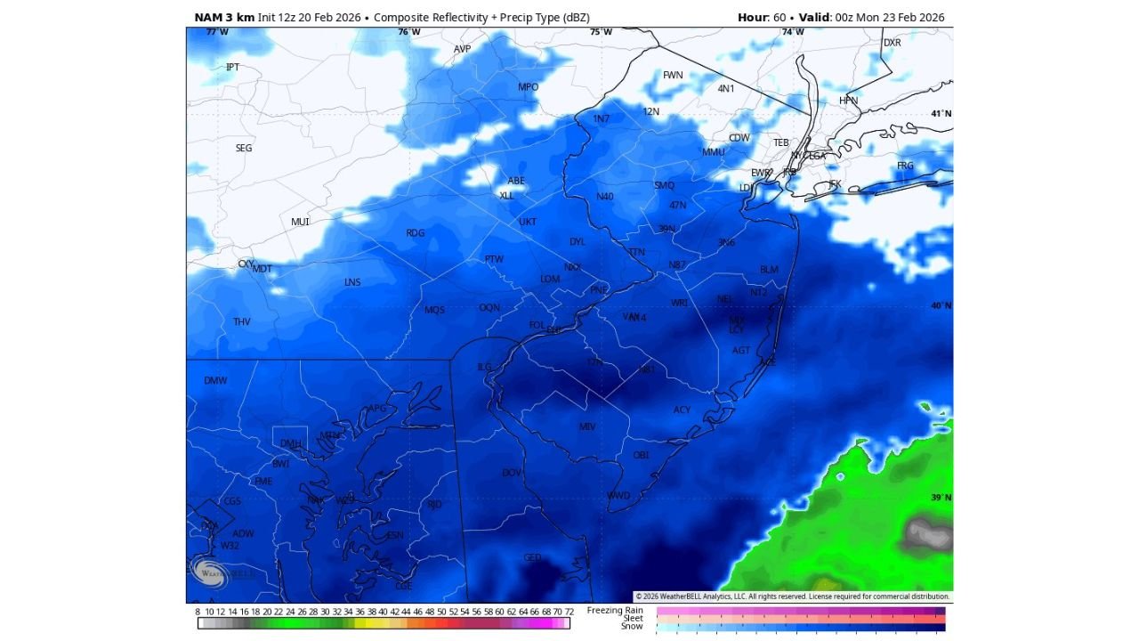
The latest NAM 3km guidance, initialized at 12z February 20, shows a broad shield of snow overspreading eastern Pennsylvania, New Jersey, and into parts of southern New York.
NAM 3km Shows Widespread Snow Across Eastern Pennsylvania
The composite reflectivity and precipitation type output indicates steady snow from Reading (RDG) and Lancaster (LNS) through Allentown (ABE) and into the Pocono region near MPO.
Snow appears expansive and uniform across much of eastern Pennsylvania, with higher reflectivity bands suggesting periods of moderate snowfall. The model depiction shows little mixing across the interior, signaling a predominantly snow event for much of the region.
Areas including UKT, PTW, DYL, and TTN appear solidly within the snow shield at this time frame.
Snow Expands Into Central and Northern New Jersey
Across New Jersey, snowfall coverage appears widespread, including Trenton (TTN), Newark (EWR), Morristown (MMU), and Somerset (SMQ). Even coastal sections show primarily snow at the valid time displayed.
Southern New Jersey, including Atlantic City (ACY), Millville (MIV), and surrounding communities, are also depicted within the snow shield, though the southern fringe shows slightly lighter intensity compared to central and northern sections.
The lack of a strong coastal rain signal in this frame suggests cold air is sufficiently entrenched inland at this stage of the storm.
Coastal System Positioned Offshore
Off the New Jersey coast, reflectivity increases over the Atlantic waters, indicating the developing low-pressure system is positioned offshore. This coastal placement is critical, as it supports snowfall inland rather than drawing warm marine air deep into the Mid-Atlantic.
If the low remains on a similar track, snow would remain the dominant precipitation type across eastern Pennsylvania and much of New Jersey.
Growing Model Agreement Boosts Forecast Confidence
While no model is perfect, forecasters note that seeing the NAM, EURO AI, and GFS coming into closer alignment is an important step toward forecast confidence. When multiple guidance packages begin to cluster around a similar solution, the likelihood of a meaningful event increases.
The NAM has shown consistent positioning this winter, and broader agreement now suggests that February 23 could bring a widespread snowfall event to parts of the Mid-Atlantic and Northeast.
Timing and Potential Impacts
The valid time shown—00z Monday, February 23—places the storm impacting the region late Sunday into early Monday. Depending on final track and intensity, this could affect travel across major corridors including I-78, I-80, the New Jersey Turnpike, and surrounding roadways.
As always, fine details such as snowfall totals and band placement will depend on the exact storm evolution over the next several model cycles.
Residents across eastern Pennsylvania, New Jersey, and nearby areas should continue monitoring updated forecasts as model agreement improves.
If winter weather begins impacting your area, share your local conditions at CabarrusWeekly.com to help keep others informed.