Narrow Heavy Snow Band May Target I-78 to I-84 Corridor Across Pennsylvania, Northern New Jersey and Southern New York With 3–8 Inches Possible
PENNSYLVANIA — A highly localized heavy snow band may develop late Sunday into early Monday, setting up somewhere between the Interstate 78 and Interstate 84 corridors, where a narrow “sweet spot” could see 3 to 8 inches of snowfall while surrounding areas receive much less.
Forecast guidance highlights a tight temperature gradient and favorable upper-level dynamics that may concentrate snowfall into a confined zone rather than a widespread winter storm.
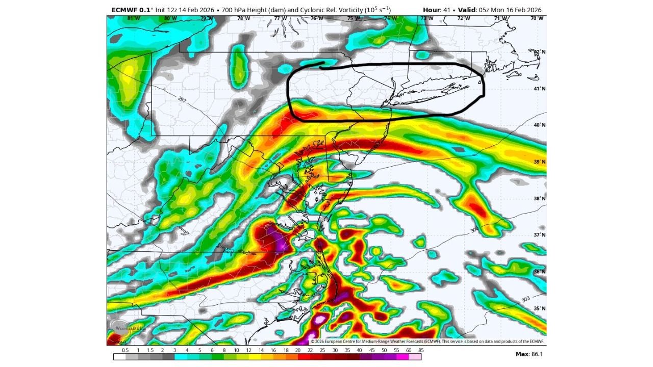
Heavy Snow Axis Dependent on 700 mb Low Placement
The key to this setup lies near the 700 mb low, an important mid-level feature that often controls where the most intense snow banding develops.
Forecasters indicate that the heaviest snow will occur where surface temperatures are at or just below freezing, combined with proximity to the mid-level low circulation. This overlap enhances lift and promotes stronger snowfall rates.
If the band aligns properly, snowfall rates could briefly intensify, leading to localized accumulation in a relatively short window of time.
I-78 to I-84 Corridor in Focus
The most likely corridor for this narrow heavy band stretches from eastern Pennsylvania across northern New Jersey into southern New York, including communities near and between the I-78 and I-84 highways.
This zone includes areas north of the Philadelphia metro and south of Albany, potentially impacting interior sections of:
Eastern Pennsylvania
Northern New Jersey
Lower Hudson Valley of New York
Outside of this corridor, snowfall amounts are expected to drop off sharply.
Sharp Cutoff in Totals Expected
One of the defining characteristics of this system will be the sharp gradient in snowfall totals.
Areas directly under the band could see 3 to 8 inches, while locations only 20 to 40 miles away may observe significantly lower totals. This type of mesoscale banding is common in marginal temperature setups where dynamic cooling and lift determine who sees accumulating snow.
Communities south of the band, particularly closer to the I-95 corridor, may remain too warm for substantial accumulation.
Timing and Travel Considerations
The heaviest snow potential appears late Sunday night into early Monday morning, a timeframe that could affect overnight travel and the early commute.
If the band locks into place over a populated corridor, localized slick roads and reduced visibility will be possible despite the overall limited geographic footprint of the storm.
Because this is a narrow and sensitive setup, small shifts north or south will dramatically change who sees higher totals.
We will continue monitoring model trends as the storm approaches. If you are located between I-78 and I-84 and begin seeing heavier snow rates, share your reports with us at CabarrusWeekly.com.