Narrow Snow Band to Target Berkshires With 4–7 Inches While Central and Eastern Southern New England See 1–4 Inches After Rain Changes to Snow
SOUTHERN NEW ENGLAND — An extremely narrow swath of moderate snowfall is expected to develop tomorrow afternoon and continue into the overnight hours, bringing a sharp gradient in totals across the region.
For many communities, precipitation will begin as rain before transitioning to snow, especially as colder air filters in during the evening. The heaviest accumulation will be confined to a tight corridor, making location critical in determining final totals.
Heaviest Snow Focused in the Berkshires
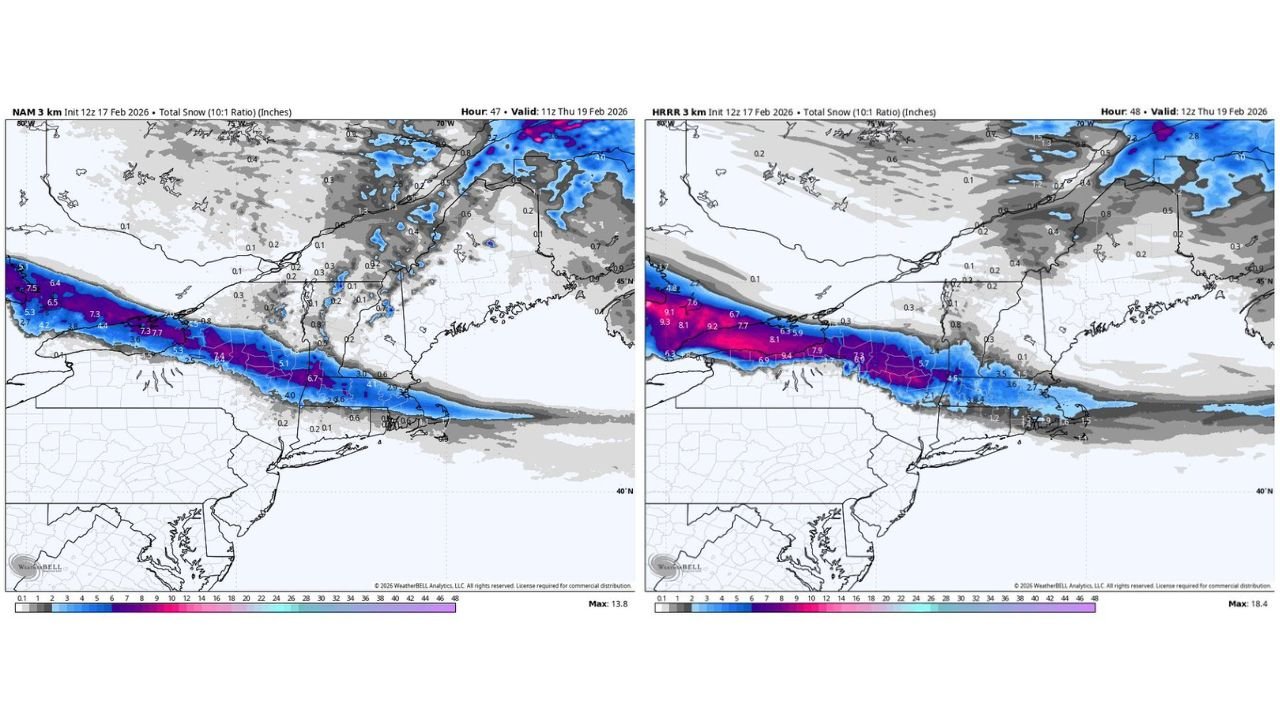
Forecast guidance consistently highlights the Berkshires of western Massachusetts as the zone most likely to receive the highest snowfall totals.
Current projections indicate 4 to 7 inches possible in this region, where colder air and stronger lift overlap most efficiently. This narrow band is expected to stretch west-to-east across parts of western Massachusetts into nearby northern Connecticut and possibly southern Vermont.
Because the band is so narrow, a shift of just 20 to 30 miles could significantly change accumulation amounts.
Lighter Totals Across Central and Eastern SNE
Farther east into central and eastern Southern New England, snowfall totals are expected to be more modest.
Cities and towns across central Massachusetts, Rhode Island, and eastern Connecticut are more likely to see a 1 to 4 inch event, with some locations on the lower end if the rain-to-snow transition occurs later than expected.
Coastal sections may struggle to accumulate significantly at first, especially if surface temperatures remain marginal during the initial phase.
Rain-to-Snow Transition Key to Accumulation
One of the most important factors in this setup is timing. Precipitation is expected to start as rain for most areas before dynamic cooling allows snow to take over.
If the transition occurs earlier in the afternoon or evening, totals could trend toward the higher end of projections. A delayed changeover would reduce overall accumulation, especially in eastern areas.
Overnight cooling will support better sticking conditions once snow becomes the dominant precipitation type.
Extremely Tight Snow Gradient
Model guidance continues to show a very narrow snow band, meaning some communities may see moderate accumulation while areas just outside the band receive significantly less.
This type of setup often produces sharp cutoffs in totals over short distances. Residents in the Berkshires and adjacent western zones are currently positioned in the most favorable corridor for heavier snow.
As always with narrow bands, final placement will be refined as higher-resolution guidance updates closer to onset.
If you are in Southern New England, now is the time to prepare for rapidly changing conditions tomorrow afternoon into the overnight. Share your local snowfall reports and photos with CabarrusWeekly.com so others can track how this narrow winter band unfolds across the region.