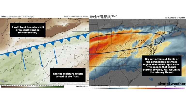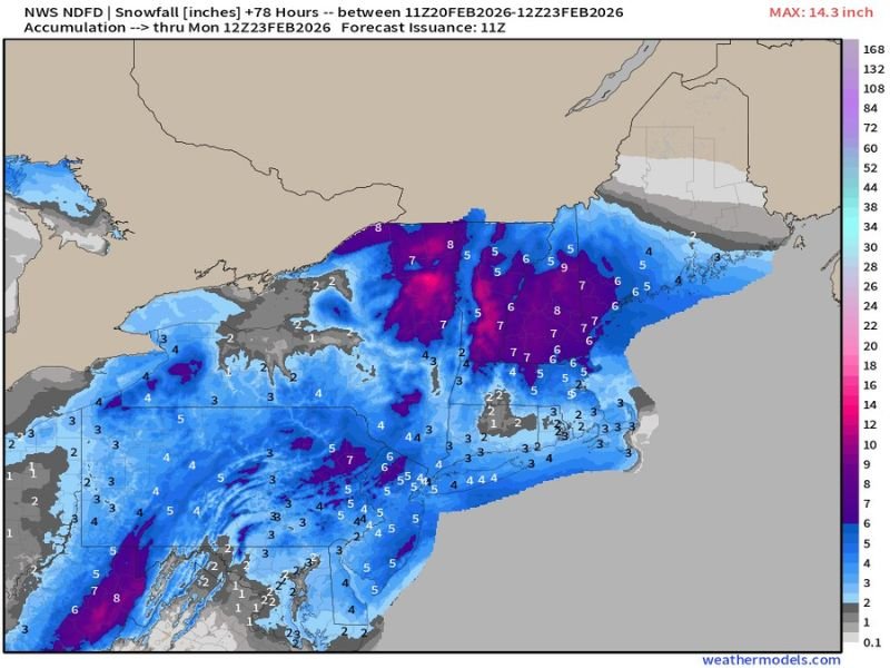
National Weather Service Snow Map Shows 6–9 Inch Band From Virginia to Southern New England Through Monday Morning
Virginia – The latest National Weather Service snowfall projection through 7:00 AM Monday highlights a widespread and steady accumulation event stretching from the central Appalachians through the Mid-Atlantic and into southern New England, with some coastal areas still snowing at that time.
The map reflects total snowfall between February 20 and early Monday, with maximum values reaching just over 14 inches in the most favored zones.
Heaviest Snow Focused From West Virginia Into Pennsylvania and New York
According to the NWS snow map, a concentrated band of 6 to 9 inches is projected across:
- West Virginia
- Western and central Pennsylvania
- Southern and central New York
Within this corridor, localized pockets near the Pennsylvania–New York border are shown in deeper purple shading, indicating totals approaching or exceeding 8 inches.
This zone appears to be the most consistent inland heavy snow band, with widespread moderate accumulations rather than isolated bursts.
Mid-Atlantic Totals Range 3–6 Inches for Many Areas
Across Virginia, Maryland, Delaware, and much of southern Pennsylvania, snowfall totals generally range from 3 to 6 inches, with locally higher pockets.
The Washington, D.C. and Baltimore metro areas fall largely within the 3–5 inch range on the map, though slightly heavier bands nearby could push some communities closer to 6 inches.
Further south into western North Carolina and eastern Tennessee, lighter but still notable accumulations of 3 to 5 inches are indicated in higher elevations, particularly along the Appalachian spine.
New Jersey and Southern New England in a 4–7 Inch Swath
New Jersey, southern Connecticut, Rhode Island, and eastern Massachusetts are largely shaded in the 4 to 7 inch range.
Coastal sections may continue seeing snow close to or even past the 7 AM Monday cutoff, meaning final totals could increase slightly beyond what is shown on this specific projection window. Northern New England — including northern Maine — appears to see lighter totals overall, generally between 1 and 4 inches.
Snow Continues Along the Coast Into Monday Morning
One key note with this projection is timing. The map explicitly runs only through 7:00 AM Monday, and snowfall may still be ongoing for parts of the coastal Northeast at that hour. That means communities along the New England shoreline could see additional accumulation beyond the totals currently displayed.
What Happens Next
As with all snow projections, placement of heavier bands can still shift slightly in updated forecasts. However, the current NWS depiction shows a broad and impactful late-season snowfall stretching from the central Appalachians through the Mid-Atlantic and into southern New England.
Residents in the 6–9 inch corridor should prepare for plowable snow, slick travel conditions, and potential delays Monday morning, especially where snowfall lingers into the early commute hours. Updated forecasts and additional snow maps will further refine totals as the system evolves.