Nebraska and Iowa Under Heavy Snow Alert as Omaha Corridor Faces 1 Inch Per Hour Snowfall Rates Early Tuesday
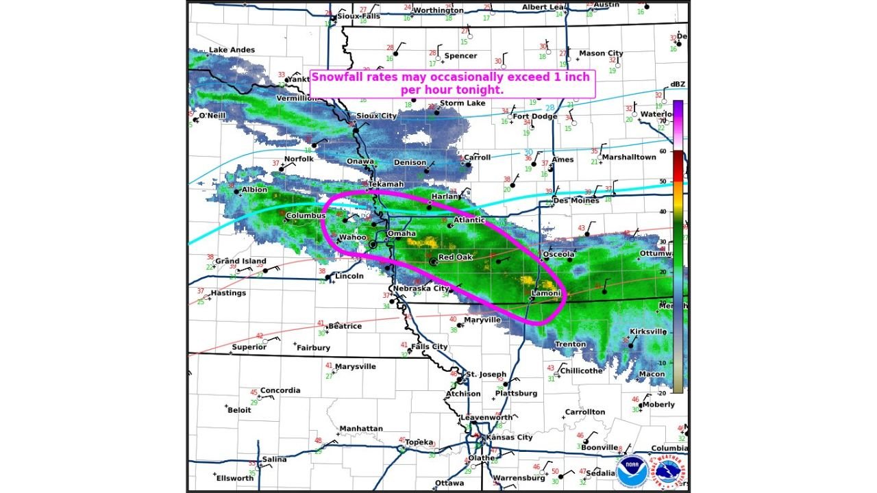
NEBRASKA — A Winter Mesoscale Discussion has been issued for heavy snow across eastern Nebraska into western Iowa, with radar trends showing intensifying snowfall rates and rapidly deteriorating conditions early Tuesday morning.
The advisory highlights a focused band of snow stretching from near Columbus and Wahoo through Omaha and into Atlantic, Red Oak, and Lamoni, where snowfall is expected to become both heavier and more impactful through the early morning hours.
Snowfall Rates Could Exceed 1 Inch Per Hour
One of the most critical concerns in this setup is the potential for:
- Snowfall rates exceeding 1 inch per hour
- Rapid accumulation in a short period of time
- Sharp visibility reductions during heavier bursts
This intense band is centered along and just south of:
- Omaha metro area
- Eastern Nebraska into western Iowa
Such rates can quickly overwhelm road treatment efforts, leading to snow-covered and slick roads within minutes.
Omaha to Southwest Iowa Corridor at Highest Risk
The most impactful zone includes:
- Omaha and Bellevue
- Wahoo and Columbus
- Atlantic and Red Oak
- Extending southeast toward Lamoni
This corridor is currently seeing a mix of precipitation transitioning into heavier, wetter snow, which tends to stick quickly to surfaces.
Transition Zone Still Active Nearby
North of the main band, including areas near:
- Sioux City
- Denison
- Carroll
precipitation is transitioning between rain, snow, and mixed precipitation, which can create additional hazards such as:
- Slushy accumulation
- Variable road conditions
- Reduced traction
Why This Setup Is Dangerous
Several factors are combining to increase impacts:
- Narrow but intense snow band focusing heavy accumulation in a small area
- Temperatures near freezing, allowing rapid changes in precipitation type
- Early morning timing, coinciding with commuter traffic buildup
Even areas just outside the heaviest band may see rapidly changing conditions.
Timing: Peak Impacts Before and During Morning Commute
The most significant impacts are expected:
- Between pre-dawn and mid-morning Tuesday
- With the heaviest snow shifting east into western Iowa over time
Travel conditions are likely to worsen quickly during this window, especially along major routes near Omaha and into Iowa.
Travel Impacts Likely Across Region
Residents should prepare for:
- Snow-covered roads and reduced visibility
- Slippery conditions on bridges and overpasses
- Potential delays and hazardous driving conditions
Stay With Cabarrus Weekly for Continuing Coverage
Cabarrus Weekly will continue to monitor this rapidly evolving winter weather situation across Nebraska and Iowa, including updates on snowfall totals, road impacts, and forecast changes.
Stay connected for the latest on winter weather threats and travel conditions across the central United States.