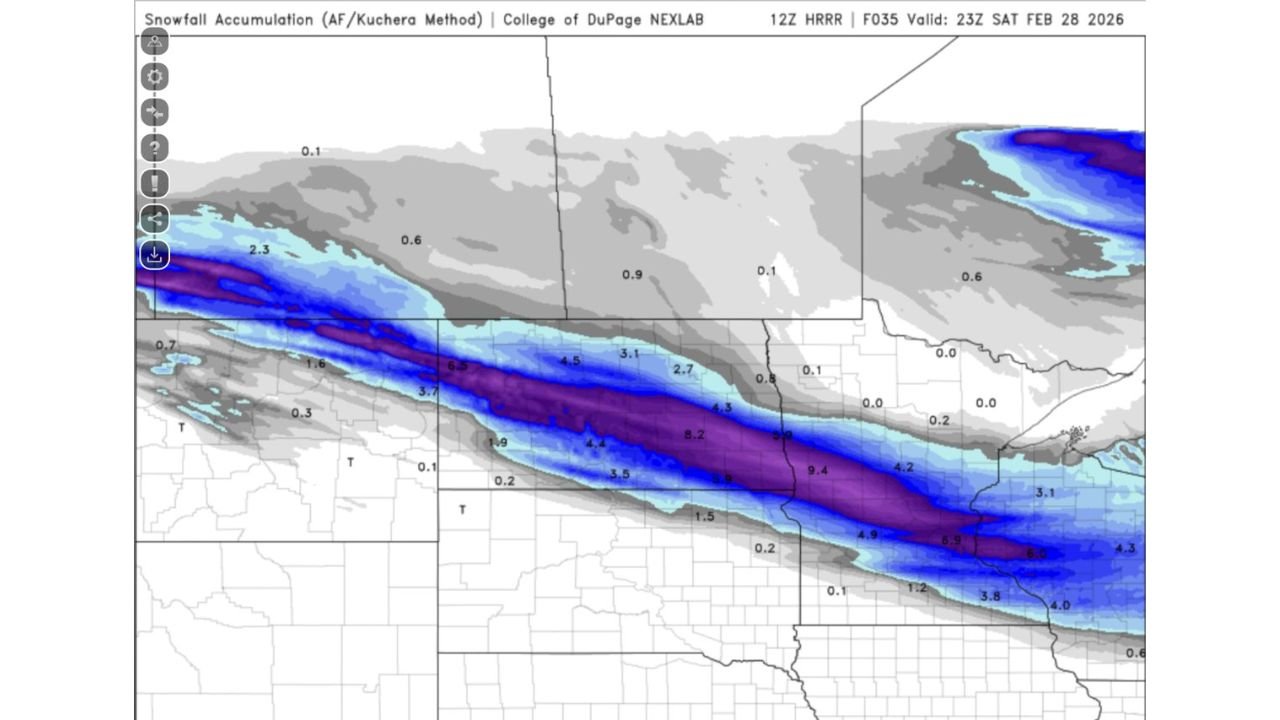
Nebraska, Iowa and Illinois Metro Areas Could See Surprise 4–9 Inch Snow Band as Latest HRRR Model Shifts Track South
UNITED STATES — A last-minute model shift is raising eyebrows tonight, as the 12Z HRRR run hints at a narrow but intense snow band that could brush parts of a major metro area tomorrow.
Before jumping to conclusions, forecasters caution this is just one model run — and fine-scale placement could shift north or south.
What the 12Z HRRR Is Showing
The latest high-resolution guidance displays a well-defined swath of heavier snowfall stretching west-to-east across portions of the central Plains into the Midwest.
Within that band, projected snowfall totals range from:
• 3–5 inches on the edges
• 6–8 inches in the core
• Isolated pockets over 9 inches
The heaviest stripe appears tightly focused, meaning small track adjustments could dramatically change who sees accumulating snow.
Why This Could Be a “Snow Surprise”
High-resolution models like the HRRR are especially sensitive to:
• Banding features
• Temperature profiles near freezing
• Small shifts in storm track
When snow bands form, they can produce rapid accumulation in just a few hours. Areas only 20–40 miles outside the band may see far less snow.
That sharp cutoff is what makes this setup particularly tricky.
Confidence Level: Still Developing
Forecasters emphasize that:
• This is a single model run
• Additional runs later today will refine placement
• Minor temperature changes could affect totals
If surface temperatures hover near freezing, snowfall efficiency can fluctuate significantly.
In other words — promising signal, but not locked in.
What This Means for North Carolina
For Cabarrus County and the broader North Carolina region, this particular HRRR run does not place the heaviest snow locally. However, narrow-band snow setups elsewhere serve as a reminder that late-season systems can still deliver quick surprises if dynamics align.
For now, no major snow event is projected locally — but we continue monitoring evolving model guidance as we transition toward early March.
Bottom Line
The latest data suggests:
• A narrow heavy snow band is possible
• Totals could exceed 6 inches in the core zone
• Track placement remains uncertain
• More clarity expected with additional model runs
If the heavier band trends closer to any major metro corridor, impacts could increase quickly.
We’ll continue tracking updates and provide refined totals once model consensus improves. Stay with CabarrusWeekly.com for the latest developments as this potential snow surprise unfolds.