“Never Trust a Spring Warm Front”: Increased Tornado Risk From Eastern Ohio to Western Pennsylvania and Western New York Including Cleveland, Pittsburgh and Buffalo
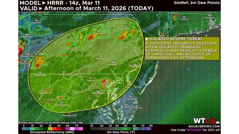
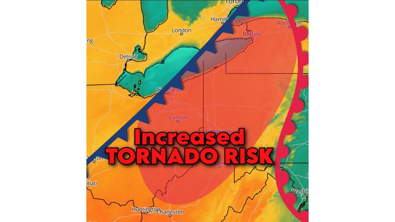
OHIO VALLEY — A springtime warm front is once again raising concerns across the Eastern Great Lakes and Upper Ohio Valley, with meteorologists highlighting an increased tornado risk across Eastern Ohio, Western Pennsylvania, and Western New York.
While forecasters stress that this setup is very unlikely to repeat the magnitude of previous severe events, the evolving warm front boundary is creating a favorable corridor for rotating storms later today.
The Warm Front Setup
The boundary is draped from near Detroit and Lake Erie eastward toward Buffalo and Rochester, extending southwest through Cleveland, Akron, Canton, and Pittsburgh, and down toward portions of West Virginia near Huntington and Charleston.
Warm fronts in early spring can be particularly deceptive. North of the boundary, air tends to be cooler and more stable. South of it, warmer and more unstable air can surge in quickly — creating a sharp contrast in temperature and wind direction.
That contrast enhances:
- Low-level wind shear
- Storm rotation potential
- Brief but strong tornado spin-ups
Areas Under Greatest Concern
The corridor highlighted for increased tornado activity includes:
- Cleveland and Akron, Ohio
- Canton and Youngstown, Ohio
- Pittsburgh, Pennsylvania
- Buffalo, New York
- Surrounding communities along and just south of Lake Erie
Western New York and Western Pennsylvania appear especially sensitive if storms can track along the warm front itself.
Why Tornado Risk Is Elevated
Storms interacting with a warm front often tap into stronger low-level wind shear. Even if overall instability is moderate, the wind profile alone can support rotating updrafts.
This means:
- Discrete storms could briefly rotate
- Quick spin-up tornadoes are possible
- Storm intensity may fluctuate rapidly near the boundary
Forecasters emphasize this is not expected to be a widespread outbreak, but the ingredients are present for isolated tornado activity — particularly near the boundary zone.
What Makes Spring Warm Fronts Tricky
Spring systems often involve shallow cool air near the surface with warmer air riding above it. As the front lifts northward:
- Wind direction changes sharply over short distances
- Storms can intensify quickly
- Tornado risk can increase with little warning
These scenarios often produce localized severe weather rather than broad, long-track tornado outbreaks.
Bottom Line
An increased tornado risk exists today across Eastern Ohio, Western Pennsylvania, and Western New York, including major population centers like Cleveland, Pittsburgh, and Buffalo. While a repeat of prior severe magnitude appears unlikely, the warm front boundary is creating a focused corridor where rotating storms could develop.
Residents in these areas should stay alert this afternoon and evening, particularly near and just south of the warm front.
CabarrusWeekly.com will continue monitoring developments as this spring system evolves.