New England Arctic Blast Brings Dangerous Wind Chills to Massachusetts, Maine, Vermont, New Hampshire, Connecticut, and Rhode Island This Weekend
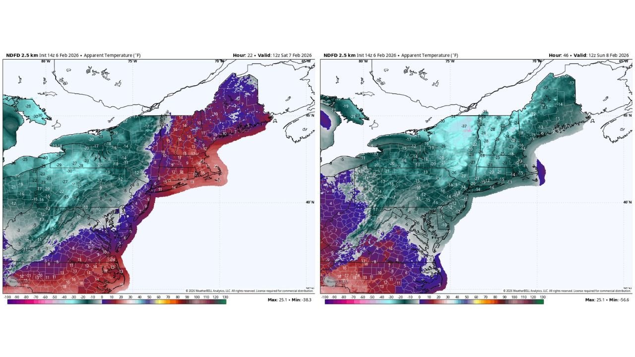
UNITED STATES — A brutal shot of Arctic air is charging into New England this weekend, setting the stage for some of the coldest “feels-like” temperatures of the season across Massachusetts, Maine, Vermont, New Hampshire, Connecticut, and Rhode Island. Forecast apparent temperature (wind chill) maps show conditions deteriorating quickly late Saturday into early Sunday, with widespread subzero wind chills and several interior zones dropping into the 20 to 30 degrees below zero range.
What the maps show for Saturday morning
The first apparent temperature map (valid 12z Saturday, Feb. 7, 2026) shows the leading edge of the cold settling in, especially across the interior Northeast. While parts of southern New England may still be hovering in the single digits to teens early Saturday, the colder air is already pressing in from the west and north, setting up a much harsher second act as the day goes on and winds strengthen.
In other words: Saturday morning is the start of the plunge, not the finish line.
Sunday morning looks like the worst of it
The second map (valid 12z Sunday, Feb. 8, 2026) is where the “FeBRRRuary” headline really earns its name.
Across much of northern and central New England, the apparent temperature values drop hard:
- Maine, Vermont, New Hampshire: widespread -15 to -25°F wind chills, with colder pockets pushing even lower
- Interior Massachusetts and Connecticut: many areas in the -10 to -20°F range
- Rhode Island and coastal southern New England: still sharply cold, commonly near or below 0°F, with wind making it feel much worse
Some interior readings on the guidance dip into the -30s (and even lower in a few spots), which matches the expectation of localized 20–30 below wind chills in the coldest corridors.
Why this cold is different from a “normal” chilly weekend
This isn’t just a cold morning followed by a tolerable afternoon. The setup combines two things that make it dangerous:
- A deep Arctic airmass (cold that holds its ground)
- Strong winds (which drive wind chills down and accelerate frostbite risk)
That combination is why even short outdoor exposures can become a problem—especially for kids at games, people shoveling, anyone dealing with a car issue on the roadside, or folks who work outside.
Who needs to take extra precautions
If you’re in New England—or traveling into it—this is a weekend to plan like it’s a true cold-weather event:
- Keep extra layers, gloves, face covering, and hand warmers ready
- Limit time outside during the coldest window (late Saturday night into Sunday morning)
- Bring pets inside and check on neighbors who may not have reliable heat
- If you must drive, pack a quick winter kit (blanket, charger, snacks, and a way to stay warm if you get stuck)
Even if snowfall is minimal, wind chills like this can create emergencies fast.
Why Cabarrus County readers should care
Cabarrus County won’t see wind chills like northern New England this weekend, but this kind of Arctic outbreak matters because it signals an active winter pattern capable of sending cold air surges deep into the eastern U.S. at times.
If you have family traveling to Massachusetts, Maine, Vermont, New Hampshire, Connecticut, or Rhode Island, or if you’re flying into the Northeast yourself, this is a heads-up to prepare for severe cold exposure the moment you step outside.
CabarrusWeekly.com will keep tracking the bigger pattern and whether any of this Arctic energy tries to press farther south in the days ahead. If you’re heading to the Northeast this weekend, tell us where—are you expecting to be in the coldest zone, or closer to the coast?