New England Faces Blizzard-Like Conditions as Powerful 500mb System Triggers Heavy Snow, Strong Winds, and Bitter Cold
NEW ENGLAND — A formidable winter storm is developing across New England, with meteorologists tracking a powerful upper-level system capable of producing blizzard-like conditions from later today into tomorrow night. Forecast data shows a deep 500mb pattern similar in structure to the historic Blizzard of 1978, although this system is positioned slightly farther east. Even so, the setup remains strong enough to generate heavy snowfall, intense winds, and dangerously cold air across much of the region.
Recent model guidance indicates that the storm will rapidly intensify as it moves through the Northeast, with cold air firmly entrenched across interior and coastal areas alike. Snow is expected to become widespread, especially across southern New England, with the most persistent bands setting up near the coast and pushing inland at times.
Storm Structure Mirrors Historic Blizzard Setup
Upper-air analysis shows a classic high-impact pattern developing, with strong height anomalies and a deep trough supporting robust lift across New England. While the core of the system does not dig as far west as the 1978 storm, the overall configuration remains concerning due to the strength of the circulation and the availability of cold air.
Model imagery highlights a well-defined deformation zone stretching across New England, where snowfall rates may increase significantly for several hours. These dynamics raise the potential for rapidly deteriorating travel conditions, particularly where snow bands become stationary.
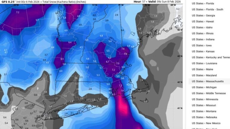
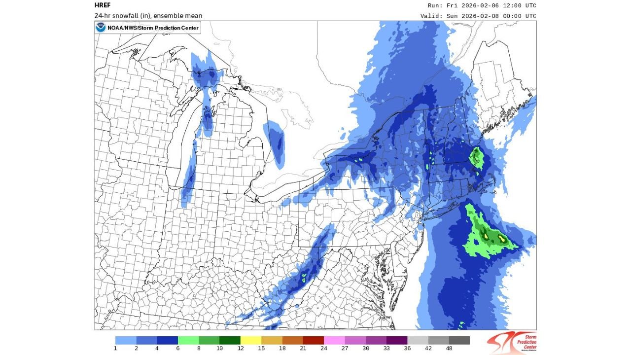
Heavy Snowfall Focused Across Southern New England
High-resolution snowfall guidance continues to show accumulating snow across much of southern New England, with the highest potential totals from Cape Ann northward into coastal New Hampshire. Snowfall amounts increase closer to the coast, where strong ocean influence enhances moisture availability and supports heavier snowfall rates.
Farther inland, snowfall is expected to be lighter but still impactful, especially during periods when convergent banding briefly shifts westward. Some locations could experience bursts of heavy snow capable of quickly reducing visibility and covering roadways.
Strong Winds and Bitter Cold Add to Impact
In addition to snowfall, strong winds are expected to develop as the storm deepens offshore. Gusts may be strong enough to cause blowing and drifting snow, further reducing visibility and contributing to hazardous travel conditions. The combination of snow and wind may produce near-blizzard conditions in exposed areas, especially along the coast.
Temperatures will remain bitterly cold throughout the event, ensuring snow remains dry and powdery. This will make it easier for winds to lift snow from the surface, prolonging poor visibility even after the heaviest snowfall tapers off.
Conditions Deteriorate Through Tonight
Forecast timing suggests conditions will worsen later today and persist into tomorrow night, with the most intense impacts occurring as the storm strengthens offshore. Residents across New England are urged to prepare for difficult travel, reduced visibility, and rapidly changing conditions as the system evolves.
While confidence is highest in significant impacts near the coast, inland areas should not dismiss the threat, as subtle shifts in band placement could lead to localized higher totals.
This storm remains a dynamic situation, and further updates will refine snowfall expectations and impact zones as the system unfolds.
Stay with CabarrusWeekly.com for continued weather updates and detailed breakdowns as this powerful winter storm impacts New England.