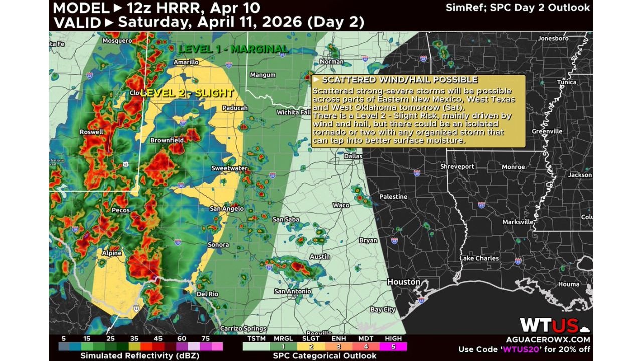
New Mexico, Texas, Oklahoma Under Slight Risk Saturday as Roswell, Amarillo, San Angelo Face Hail, Damaging Winds and Isolated Tornado Threat
UNITED STATES — A developing severe weather setup is expected Saturday across eastern New Mexico, west Texas, and parts of Oklahoma, where forecasters have outlined a Level 2 Slight Risk for scattered strong to severe thunderstorms.
The system is expected to bring multiple rounds of storms, particularly during the afternoon and evening hours, with the potential for large hail, damaging winds, and an isolated tornado or two.
Slight Risk Zone Focused on Eastern New Mexico and West Texas
The core of the severe weather threat is centered across:
- Eastern New Mexico (including Roswell, Clovis)
- West Texas (including Midland, San Angelo, Sweetwater, Brownfield)
- Western Oklahoma (including areas near Altus and Mangum)
This region falls within the Level 2 Slight Risk zone, indicating a higher likelihood of organized storm clusters capable of producing severe impacts.
Surrounding areas, including parts of the Texas Panhandle and central Oklahoma, are under a Level 1 Marginal Risk, where storms may still occur but with lower intensity.
Storm Development and Coverage
Forecast models show widespread thunderstorm development beginning in eastern New Mexico, then pushing eastward into west Texas and Oklahoma.
Key expectations include:
- Clusters of storms forming along a dryline or boundary zone
- Gradual eastward expansion through the afternoon
- Continued storm activity into the evening hours
Storms in this setup could become more organized if they tap into better moisture, increasing the potential for stronger impacts.
Main Hazards: Hail and Wind Lead the Threat
The primary concerns with Saturday’s storms include:
- Large hail, potentially damaging vehicles and property
- Damaging wind gusts, especially with stronger storm cores
- Isolated tornado threat, particularly with any storm that becomes well-organized
While tornado risk remains limited, it cannot be ruled out, especially in areas where storms interact with favorable surface conditions.
Areas That Could See the Strongest Storms
The most intense storms are expected from southeast New Mexico into west-central Texas, including:
- Roswell
- Midland
- San Angelo
- Sweetwater
As storms push east, western Oklahoma could see weakening but still impactful storms, especially during the evening timeframe.
Timing: Afternoon Through Late Evening
The overall storm timeline suggests:
- Initial development: Early to mid-afternoon in New Mexico
- Peak intensity: Late afternoon into evening across west Texas
- Eastward progression: Into Oklahoma during evening hours
Storms are expected to gradually weaken later at night but may still produce isolated severe impacts before dissipating.
What This Means for Residents
Residents across the Slight Risk zone should prepare for:
- Rapidly changing weather conditions Saturday afternoon and evening
- Potential travel disruptions due to storms
- Brief but intense severe weather episodes
Outdoor plans may need adjustment, especially in west Texas and eastern New Mexico where storm coverage is expected to be highest.
Final Outlook
Saturday’s setup is shaping into a classic springtime severe weather pattern across the southern Plains, with scattered but potentially strong storms developing along a favorable boundary zone.
While not expected to be a widespread outbreak, the combination of hail, wind, and isolated tornado potential makes this a situation to watch closely.
Stay with CabarrusWeekly.com for continued updates as this storm system evolves.