New Storm System Targets Illinois, Indiana, Ohio With Renewed Severe Weather Threat Late Tuesday Into Wednesday Morning
OHIO — Just as the current round of storms begins to move out, forecasters are already tracking another developing system that could bring renewed severe weather across the Midwest and Ohio Valley next week, with the most active window expected Tuesday evening through early Wednesday morning.
Another Cold Front Sets the Stage for New Storm Threat
Weather models are signaling that a fresh cold front will sweep across the central United States, providing the ingredients needed for another round of thunderstorms.
The projected setup shows:
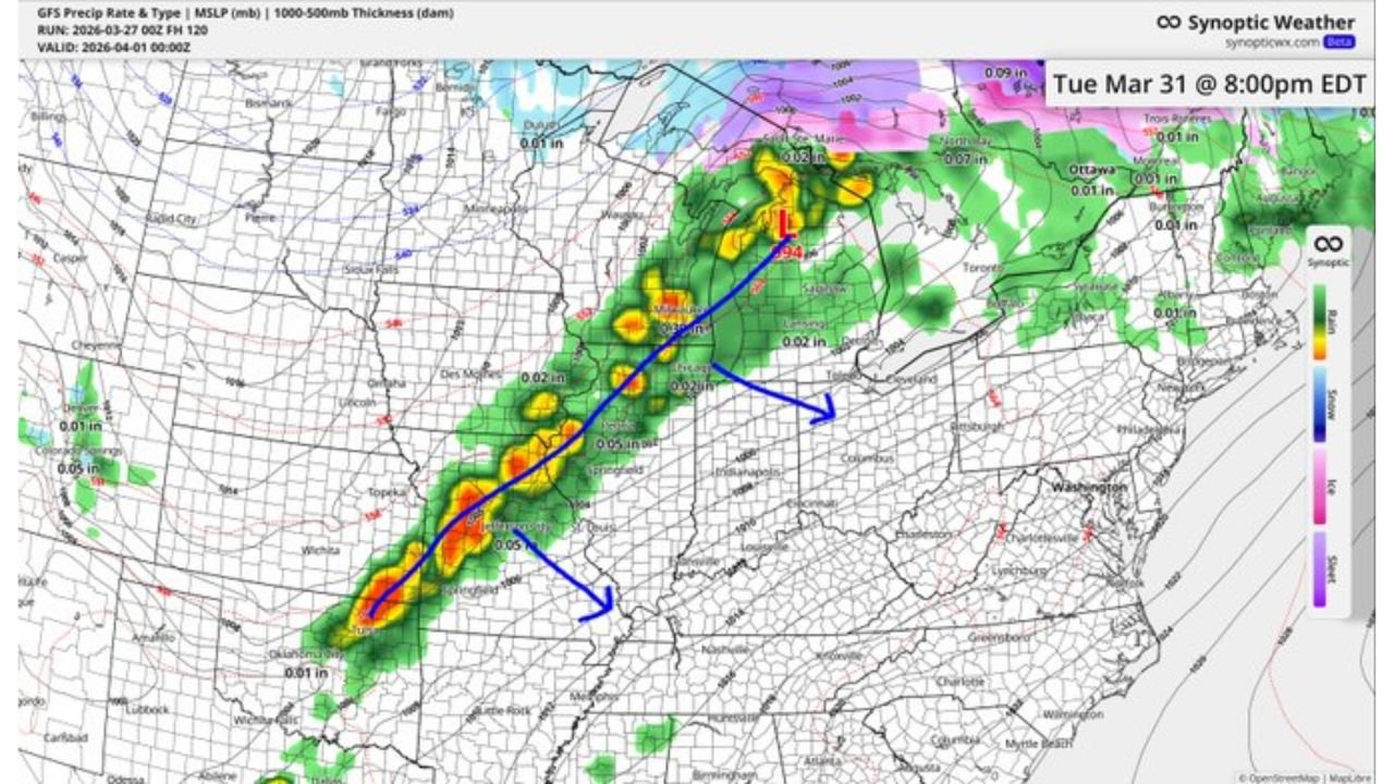
- A developing storm line stretching from Missouri through Illinois into Indiana and Ohio
- Storm activity building late Tuesday afternoon and intensifying into the evening
- Continued movement eastward into the overnight hours
This type of system typically favors organized lines of storms, capable of producing widespread impacts over multiple states.
Areas Most Likely to See Storm Activity
Current projections highlight a corridor of concern including:
- Illinois: Peoria, Springfield, Chicago
- Indiana: Indianapolis, Fort Wayne, Lafayette
- Ohio: Dayton, Columbus, Toledo
The highest concentration of storm activity appears likely from central Illinois into northern Indiana and northwest Ohio, where instability and frontal forcing align most strongly.
Main Threats: Damaging Winds and Large Hail
At this stage, the primary risks include:
- Strong to damaging wind gusts (40–60+ mph)
- Large hail in stronger storm cores
- Frequent lightning and heavy downpours
Forecast notes indicate that tornado potential currently appears low, but that could change as the system evolves closer to the event.
Timing Breakdown Across the Region
Based on current model guidance:
- Tuesday Afternoon: Storms begin developing in Missouri and western Illinois
- Tuesday Evening: Strongest storms push into Illinois and Indiana
- Late Night / Early Wednesday: Storms reach Ohio and begin weakening
This overnight timing is particularly important, as severe weather after dark can be harder to track and respond to.
Signals Still Developing, Forecast May Shift
Meteorologists emphasize that fine-tuning is still needed with several days remaining before the event.
Key uncertainties include:
- Exact placement of the strongest storm corridor
- How intense instability becomes ahead of the front
- Whether storm modes favor linear winds or more isolated severe cells
Because of this, the risk zones could shift north or south in upcoming updates.
Larger Pattern Suggests Continued Active Weather
This upcoming system is part of a broader pattern showing:
- Repeated disturbances moving across the central U.S.
- Ongoing storm chances from the Plains into the Midwest
- A transition toward a more active early April severe weather setup
The consistency in model signals suggests this won’t be an isolated event, but rather part of a continuing stretch of unsettled weather.
What Residents Should Watch For
With several days still to go, residents across Illinois, Indiana, and Ohio should:
- Monitor forecast updates closely
- Prepare for potential evening and overnight storms
- Ensure weather alerts are enabled ahead of Tuesday
Even though details are still coming into focus, the setup is already signaling another round of impactful weather could be on the way.
Stay with CabarrusWeekly.com for continuing updates as this developing storm system becomes clearer.