Next Week Midweek Threat Builds Across Florida as 2 to 4 Inch Rainfall Expands and Localized 6 Inch Totals Raise Flood Concerns
FLORIDA — A soaking pattern is setting up across the state heading into next week, with increasing confidence that widespread heavy rainfall and potential flooding issues will develop as a slow-moving system stalls over the region.
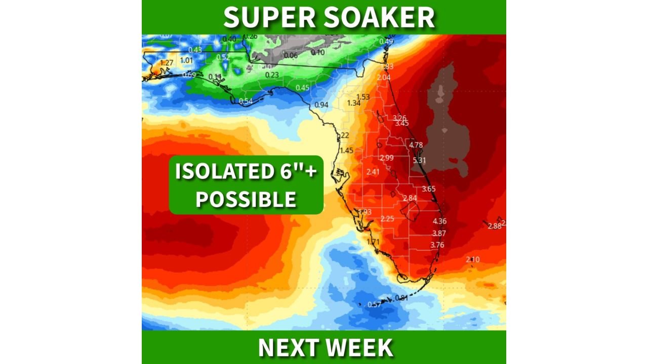
Forecast data shows 2 to 4 inches of rain likely across much of Florida, with some areas—especially along the peninsula—facing the risk of isolated totals exceeding 6 inches. This setup raises concerns for localized flooding, particularly in areas prone to poor drainage.
Why This System Could Turn Into a “Super Soaker” Event
The primary driver behind this wet pattern is a stalling frontal boundary that is expected to linger across Florida. When fronts slow down or stall, they allow rain-producing systems to repeatedly move over the same areas.
As the week progresses:
- Moisture will continue to feed into the system
- Rain bands may repeatedly impact the same locations
- Rainfall totals will begin to add up quickly
This type of setup is often associated with prolonged rainfall events rather than quick-moving storms, increasing the flood risk.
Midweek Could Be the Most Impactful Period
Conditions are expected to become more active by midweek, when a developing area of low pressure east of the Florida Peninsula enhances the overall system.
This could lead to:
- Heavier rainfall rates
- More organized bands of storms
- Increasing wind impacts along the coast
The combination of these factors may cause conditions to deteriorate quickly during the middle of the week, especially across central and eastern parts of the state.
Wind Gusts Add Another Layer of Concern
In addition to heavy rain, the system may also bring wind gusts of 30 to 40+ mph, particularly along Florida’s east coast.
These winds could:
- Make driving conditions more difficult
- Lead to minor power outages in isolated areas
- Increase coastal impacts depending on storm positioning
While flooding remains the primary concern, wind-driven rain could worsen conditions in coastal communities.
Drought Relief Comes With a Trade-Off
One of the few positives from this setup is that it may bring much-needed drought relief to parts of Florida.
However, there is a downside:
- Rainfall arriving too quickly can overwhelm the ground
- Instead of soaking in, water may run off and cause flooding
- Urban areas could see rapid water accumulation
This creates a situation where beneficial rain can quickly turn into a flooding concern if totals climb too high in a short time.
What Residents Should Watch Heading Into Next Week
With confidence increasing in a wetter pattern, Florida residents should begin preparing for:
- Periods of heavy rain and thunderstorms
- Possible localized flooding, especially in low-lying areas
- Windy conditions near the coast
The exact placement of the heaviest rain will depend on how the system evolves, but multiple rounds of rain are likely across the state.
Stay Updated With Cabarrus Weekly
For the latest updates on Florida’s developing heavy rain threat, flooding risks, and changing storm conditions, stay connected with Cabarrus Weekly. Share this update with others across Florida and keep monitoring forecasts as this potentially impactful weather pattern unfolds.