Nine Tornado Warnings Active Across Louisiana as QLCS Twisters Target Lake Charles Along I-10 and Areas West of Alexandria
LOUISIANA — A dangerous severe weather outbreak is unfolding tonight with nine tornado warnings active across the state, as a powerful squall line pushes eastward and produces embedded QLCS tornadoes.
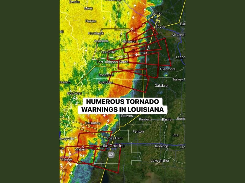
The most concentrated cluster of warnings is located near Lake Charles along the I-10 corridor, with additional tornado warnings issued west of Alexandria. Radar imagery shows a well-defined line of intense thunderstorms stretching from the Gulf Coast northward through central Louisiana.
Cluster of Tornado Warnings Near Lake Charles and I-10
A significant grouping of tornado warnings is focused around Lake Charles, Moss Bluff, Vinton, and DeQuincy, where the line of storms is producing strong rotation embedded within heavy rain and lightning.
Communities along Interstate 10, including areas between Orange, Texas and Lake Charles, are directly under the most intense portion of the squall line. These storms are moving quickly and contain circulations capable of producing brief but dangerous tornadoes.
The radar signature shows classic QLCS characteristics, meaning tornadoes can spin up rapidly within the line with little visual confirmation, especially at night.
Additional Warnings West of Alexandria
Farther north, multiple tornado warnings are also active west of Alexandria, impacting areas such as Leesville, Simpson, Boyce, Glenmora, and Colfax.
The line is producing intense rainfall rates and frequent lightning while embedded circulations track eastward. Storms in this corridor are capable of both damaging straight-line winds and short-lived tornadoes. Because these tornadoes are embedded within a solid squall line, they may not be long-tracked but can still cause significant localized damage.
QLCS Tornado Setup Increasing Risk
This event is being driven by a Quasi-Linear Convective System (QLCS) — a long, organized line of thunderstorms capable of producing spin-up tornadoes along its leading edge.
QLCS tornadoes often develop quickly and can be rain-wrapped, making them difficult to see and detect visually. The combination of heavy precipitation and rapid storm motion increases the danger, especially for motorists and residents without immediate access to weather alerts.
The strongest storms are currently aligned from southwest Louisiana near the Texas border through central parts of the state, maintaining intensity as they move east.
Timing and Ongoing Threat
With nine active tornado warnings, this is a widespread severe weather event rather than isolated supercells. The squall line continues to surge eastward, and additional warnings are possible as storms impact more communities overnight. Areas near Lake Charles along I-10 and communities west of Alexandria remain under the highest immediate threat, but the risk will shift east as the line advances.
Residents in warned areas should remain in safe shelter until warnings expire and stay tuned to local alerts. If you are in Louisiana and experiencing severe weather tonight, share your local conditions and updates with CabarrusWeekly.com so others can stay informed as this dangerous squall line continues moving across the state.