NOAA Flags Slight Risk of Heavy Rainfall from Texas to the Ohio Valley March 4–10, Including Arkansas, Missouri, Illinois and Indiana
UNITED STATES — The Climate Prediction Center is highlighting a developing risk of heavy precipitation from March 4 through March 10, 2026, with a broad corridor stretching from parts of Texas northward into the Mid-Mississippi and Ohio Valleys.
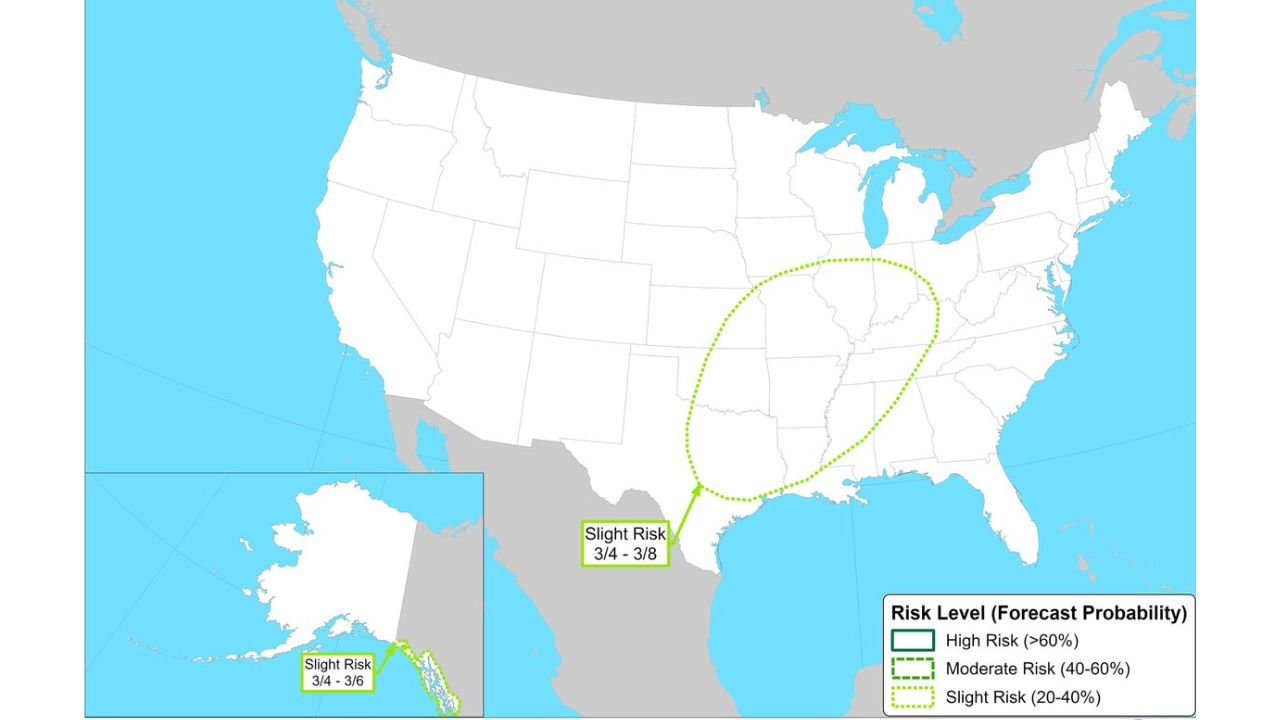
Slight Risk Area Spans South-Central to Midwest States
Forecast guidance outlines a Slight Risk (20–40% probability) zone extending from eastern Texas and Louisiana north through Arkansas, Missouri, Illinois, Indiana, and into portions of the Ohio Valley.
The risk area forms an elongated oval shape oriented southwest to northeast, suggesting a storm track that may repeatedly move across the same region during the early March period.
While categorized as a slight risk, the multi-day window increases the potential for periods of moderate to heavy rainfall within this corridor.
Focus on March 4–8 Within the Broader Window
Within the overall March 4–10 timeframe, the core heavy rainfall concern appears centered on March 4 through March 8, when atmospheric conditions may align for enhanced precipitation.
States most directly included in the highlighted area include:
Texas
Arkansas
Missouri
Illinois
Indiana
Parts of Kentucky and surrounding Ohio Valley states
This setup often indicates the potential for repeated rounds of rain, especially if a frontal boundary stalls or a series of disturbances tracks along the same path.
Flooding Concerns Depend on Storm Evolution
Although the current outlook is categorized as slight risk, impacts will depend heavily on how individual storm systems evolve.
If rainfall occurs in multiple waves, localized totals could increase enough to raise concerns for:
Urban and small stream flooding
Ponding on roadways
River rises in susceptible basins
Conversely, if systems move progressively without stalling, rainfall may be spread out enough to limit more significant impacts.
Alaska Also Included in Heavy Precipitation Outlook
In addition to the central U.S. corridor, the outlook also flags a Slight Risk of heavy precipitation across parts of southern Alaska between March 4 and March 6.
This suggests a separate storm system impacting the region during the early part of the forecast period.
Early March Pattern Worth Monitoring
As the calendar turns to March, transitional seasonal patterns often bring more dynamic storm systems capable of producing heavier precipitation.
Residents across Texas, Arkansas, Missouri, Illinois, Indiana, and the broader Ohio Valley should monitor updated forecasts as the March 4–10 window approaches.
If you live within the highlighted area, stay alert for evolving rainfall projections and share local conditions with us at CabarrusWeekly.com as this early March pattern develops.