“Norlun Trough” Snow Setup Could Create Sharp Town-to-Town Swings Across Massachusetts, Connecticut and Rhode Island With 0–6 Inches on the Table
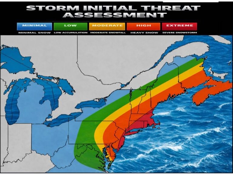
UNITED STATES — A first-call “crayon map” forecast is flagging a classic Norlun trough setup for Southern New England, warning that the heaviest snow may come down in narrow corridors that can shift east or west—but with growing confidence that eastern Massachusetts ends up on the favorable side of the band.
What a “Norlun Trough” Means for This Forecast
A Norlun trough is notorious in New England winter weather because it can behave like a skinny snow conveyor belt: areas under the trough get steadier, heavier snow, while areas just outside it may only see light snow showers or a quick coating.
That’s why the map notes the position could still shift east or west. A small adjustment can move the heavier stripe from one set of towns to the next—especially from inland Massachusetts into coastal Massachusetts, or from central Connecticut into eastern Connecticut and Rhode Island.
First-Call Snow Ranges By Zone
The forecast sketch breaks the region into clear accumulation zones, with the biggest headline being the 3–6 inch potential in multiple areas.
Here’s what the map shows:
- 0–2 inches: Farther southwest near the New York City edge of the region (including parts of southwestern Connecticut).
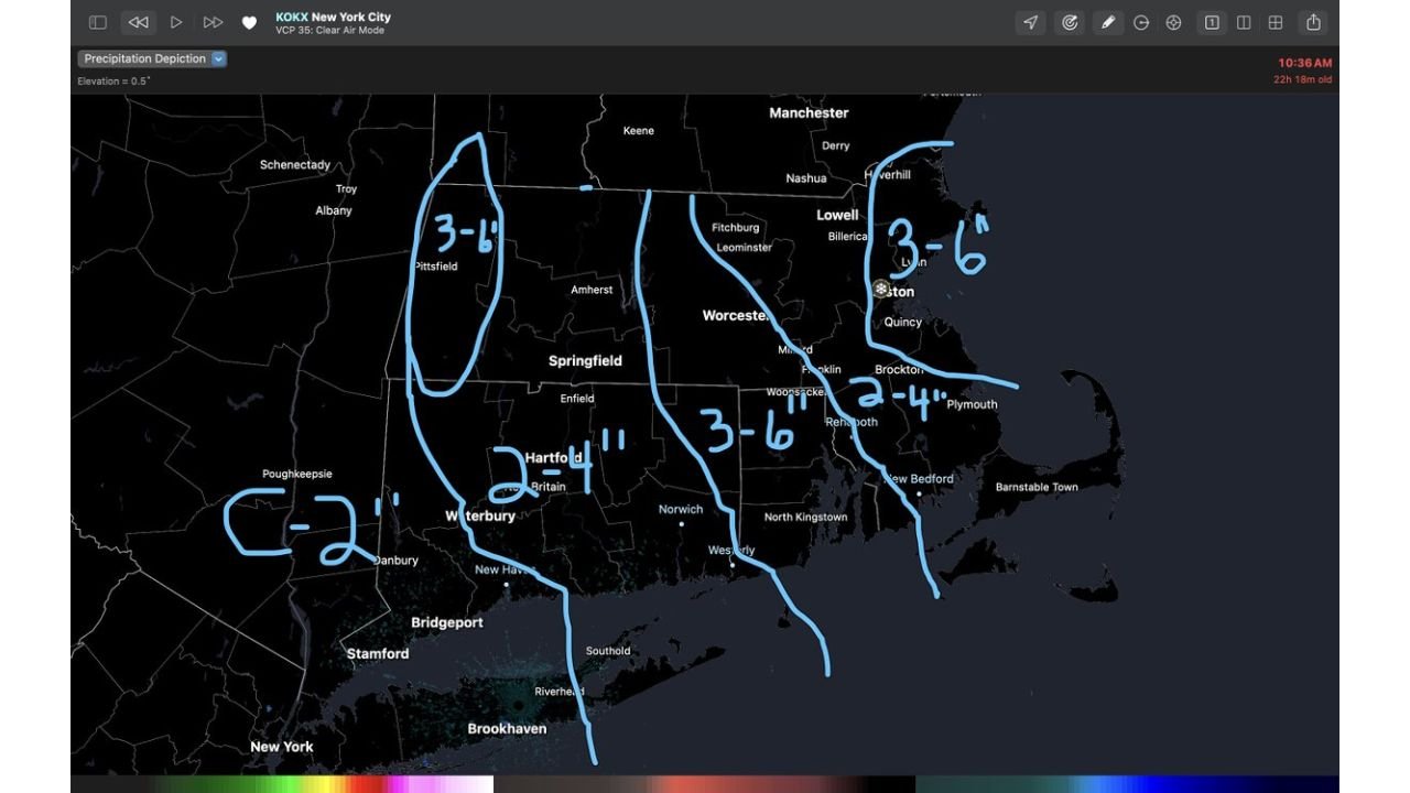
- 2–4 inches: A transition zone through portions of Connecticut and into parts of eastern Massachusetts (including sections south of Boston toward the South Shore).
- 3–6 inches: Multiple “higher-probability” zones—one over the Berkshires (western Massachusetts), another through parts of Rhode Island / eastern Connecticut, and a prominent one over eastern Massachusetts, including the coastal/plain areas near Boston and northward.
The key detail: these numbers are not presented as a smooth, statewide blanket. They’re drawn like lanes—because the trough can focus snowfall in stripes.
Massachusetts: Coast Favored, With 3–6 Inches Highlighted
The strongest confidence signal on the map is that eastern Massachusetts does well, which lines up with how these setups often behave when coastal enhancement and convergent flow kick in.
- The Boston-area/eastern Massachusetts zone is marked 3–6 inches, implying a higher likelihood of reaching plowable totals if the trough aligns as expected.
- Farther south toward the South Shore/Plymouth area, the map shows a 2–4 inch zone, suggesting slightly less intensity or less time under the best lift.
If the trough shifts just a bit, the dividing line between 2–4 and 3–6 could move quickly—so towns that are currently “2–4” could end up “3–6,” and vice versa.
Connecticut: Lower Southwest, Higher East
Connecticut is drawn as a gradient from southwest to east:
- Southwestern Connecticut is placed in the 0–2 inch range, which typically reflects either drier air intrusion, weaker forcing, or simply being too far from the best band placement.
- Farther inland and east, the map increases to 2–4 inches, and then points to a better shot at 3–6 inches closer to the eastern side of the state—especially where the trough could set up and feed steadier snow.
This is a classic “short drive, big difference” setup—where the morning totals can look dramatically different even within the same county if the band sits over one corridor longer than another.
Rhode Island: A Clear 3–6 Inch Signal
Rhode Island is positioned in one of the more favorable zones on the map, showing 3–6 inches as a primary range.
That matters because Rhode Island often benefits when the trough aligns near or just west of the coastal plain, allowing snow to persist and occasionally intensify. If the trough wobbles east, totals could become more coastal-focused; if it wobbles west, interior Rhode Island could see the best rates.
Berkshires: Western Massachusetts Also Tagged for 3–6
The map also circles the Berkshires (western Massachusetts) in a 3–6 inch zone, signaling that this may not be only a coastal story.
That can happen when a trough feature interacts with terrain and mesoscale lift, allowing western high ground to hold onto steadier snow while other spots fluctuate with band placement.
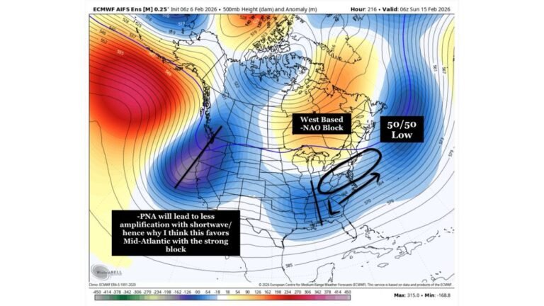
Why This Could Still Change Quickly
The map itself makes the most important point: the trough’s placement could slide east or west, and the “margin of error” is slim.
Practically, that means:
- If the trough sets up a bit farther east, the immediate coastal plain and areas closer to the ocean can cash in more.
- If it sets up a bit farther west, totals can jump inland and into parts of Connecticut/Rhode Island corridors that are currently drawn lower.
This is why many Norlun-type events don’t “verify” perfectly in advance—because the best band often isn’t fully locked until the event is underway.
What People Should Prepare For
Even though some zones are modest, the bigger risk is brief heavier bursts and fast-changing road conditions where the band forms. If you’re in the 3–6 inch corridors—especially eastern Massachusetts and Rhode Island—be ready for a period where snowfall rates increase and visibility drops.
CabarrusWeekly.com will keep tracking the latest trend in where that trough wants to set up. If you’re in Massachusetts, Connecticut, or Rhode Island, tell us what you’re seeing—did your town get into the steadiest band, or did totals fall off just a few miles away?