North Carolina and the Mid-Atlantic Monitoring Growing Nor’easter Signal for Sunday Into Monday as Coastal Low Potential Increases
NORTH CAROLINA — Forecast models are showing a growing signal for a possible nor’easter developing Sunday into Monday, though several key details remain unresolved before confidence can increase across the Mid-Atlantic and Northeast.
Coastal Low Signal Strengthening Offshore
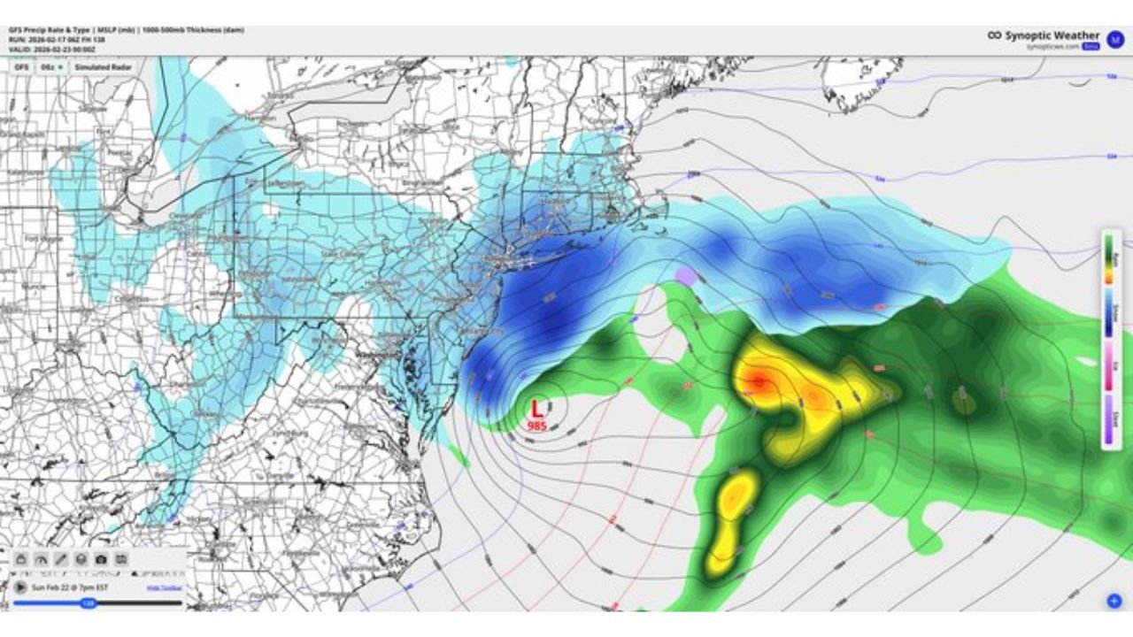
Recent ensemble and deterministic guidance, including solutions similar to the 6z GFS, indicate the potential for a coastal low developing off the Mid-Atlantic coastline late Sunday. Pressure fields show a closed low forming offshore, with the center positioned east of the Carolinas and tracking northeastward.
The exact placement of this low will be critical. A track closer to the coast would increase impacts for eastern North Carolina, Virginia, Maryland, Delaware, New Jersey, and southern New England, while a more offshore solution would limit significant precipitation inland.
At this stage, the signal is present but remains conditional.
Snow Potential Dependent on Track and Thermal Profiles
Model depictions suggest colder air wrapping into the system on its northwest side, which could support snowfall across parts of the Mid-Atlantic and interior Northeast if the storm intensifies and tracks favorably.
Ensemble mean output highlights a broad area of lower pressure offshore, but precipitation placement varies considerably. Some runs show heavier precipitation bands brushing the coastline, while others keep the heaviest precipitation well out to sea.
For North Carolina, especially central portions including the Piedmont, impacts remain uncertain. Eastern coastal sections would have the highest chance of experiencing gusty winds or precipitation should the system shift west.
Key Forecast Questions Still Unresolved
Several forecast challenges remain before specifics can be confidently communicated. These include:
The exact location and strength of the surface low as it develops off the Southeast coast.
The degree of phasing between northern and southern stream energy, which would determine storm intensity.
The amount of cold air available inland to support accumulating snow versus rain.
Small shifts in any of these factors could dramatically alter impacts from minor coastal showers to a more organized nor’easter scenario for the Mid-Atlantic and New England.
Confidence Growing in Signal, Not Yet in Details
While uncertainty remains high, forecasters note that the signal itself is increasingly consistent among guidance packages. That consistency is often the first step before confidence grows in track and impact zones.
At this time, it is appropriate to monitor the possibility of a coastal storm Sunday into Monday, particularly for areas from eastern North Carolina northward through the Mid-Atlantic into the Northeast.
Residents should avoid locking in specific snowfall or impact expectations until guidance converges over the next 48 to 72 hours.
We will continue to monitor this developing situation closely. If you are located in North Carolina or along the Mid-Atlantic coast, share your local conditions and stay informed with updates at CabarrusWeekly.com.