North Carolina and the Southeast Face Deep 120-Day Rain Deficit as New 15-Day Forecast Signals Soaking Rains from Texas to the Carolinas
NORTH CAROLINA — A long stretch of below-average rainfall across the Southeast may finally be shifting, as new forecast data suggests a wetter pattern could begin developing over the next two weeks.
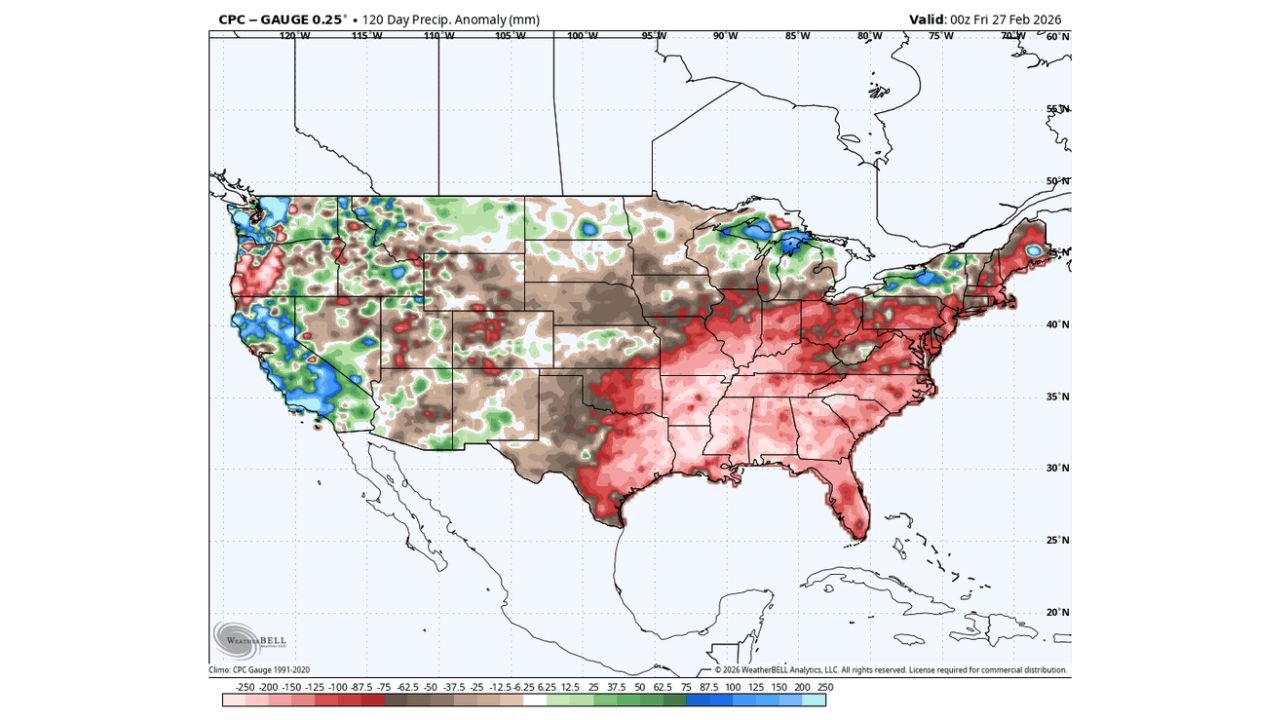
Recent 120-day precipitation anomaly maps show much of the Southeast — including North Carolina, South Carolina, Georgia, Alabama, Tennessee, and parts of Virginia — running significantly below normal on rainfall since late fall.
Large areas are shaded in red and dark pink, indicating deficits that have built steadily over the past four months.
The 120-Day Rainfall Picture: Southeast Running Dry
According to the 120-day anomaly data:
• North Carolina has been below average across much of the state
• South Carolina and Georgia show widespread deficits
• Alabama and Mississippi remain drier than normal
• Parts of the Mid-Atlantic are also running below average
Meanwhile, portions of the West Coast and areas near the Great Lakes have seen near-normal or above-normal precipitation.
For the Southeast, however, the cumulative dryness has been persistent — not extreme everywhere, but widespread enough to matter.
15-Day Forecast: A Stronger Storm Track Emerging
New ECMWF 15-day precipitation anomaly guidance shows a noticeable shift.
A broad swath of above-average rainfall (shown in blue and green) stretches from:
• Eastern Texas
• Arkansas and Louisiana
• Mississippi and Alabama
• Tennessee and Kentucky
• Into the Carolinas and Mid-Atlantic
This suggests multiple storm systems could track from the Southern Plains through the Tennessee Valley and into the Southeast over the next two weeks.
For North Carolina, that places the state directly within a corridor favored for above-normal precipitation.
What This Means for Cabarrus County
For Cabarrus County and surrounding areas:
• Rain chances may increase over the next 10–15 days
• Storm systems may track from west to east across the region
• Periods of steady rain could begin to chip away at the rainfall deficit
Forecasters caution that this pattern will not erase four months of dryness overnight. However, it could begin denting the deficit.
If the storm track remains active, soil moisture conditions could gradually improve heading into spring.
A Possible Multi-Month Shift?
Meteorological analysis accompanying the forecast suggests this may not be a one-week event.
The pattern setup hints at:
• A more active southern storm track
• Increased Gulf moisture feed
• A potential transition toward a wetter-than-average 3–4 month period
If this trend continues, the Southeast could move into a more balanced moisture regime after an extended dry stretch.
Bottom Line
The past 120 days have left much of North Carolina and the Southeast running below normal on rainfall.
But the next 15 days show a clear signal for above-average precipitation, particularly from Texas through the Tennessee Valley and into the Carolinas.
It won’t wipe out the deficit — but it could begin denting it.
Cabarrus Weekly will continue monitoring updated rainfall projections and local impacts as this potential wetter pattern develops.